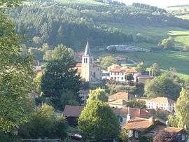
Cherier
Cherier is a commune in the Loire department in central France.
Cherier | |
|---|---|
Commune | |
 | |
Location of Cherier 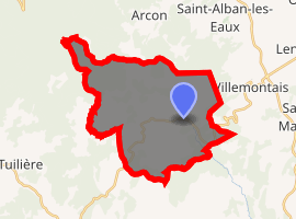
| |
 Cherier  Cherier | |
| Coordinates: 45°57′56″N 3°54′37″E | |
| Country | France |
| Region | Auvergne-Rhône-Alpes |
| Department | Loire |
| Arrondissement | Roanne |
| Canton | Renaison |
| Intercommunality | Pays d'Urfé |
| Government | |
| • Mayor (2014–2020) | Charles Laboure |
| Area 1 | 28.11 km2 (10.85 sq mi) |
| Population (2017-01-01)[1] | 559 |
| • Density | 20/km2 (52/sq mi) |
| Time zone | UTC+01:00 (CET) |
| • Summer (DST) | UTC+02:00 (CEST) |
| INSEE/Postal code | 42061 /42430 |
| Elevation | 594–1,156 m (1,949–3,793 ft) (avg. 824 m or 2,703 ft) |
| 1 French Land Register data, which excludes lakes, ponds, glaciers > 1 km2 (0.386 sq mi or 247 acres) and river estuaries. | |
Population
| Year | Pop. | ±% |
|---|---|---|
| 1793 | 930 | — |
| 1806 | 1,025 | +10.2% |
| 1821 | 1,081 | +5.5% |
| 1831 | 1,195 | +10.5% |
| 1841 | 1,190 | −0.4% |
| 1851 | 1,198 | +0.7% |
| 1861 | 1,108 | −7.5% |
| 1872 | 1,181 | +6.6% |
| 1881 | 1,104 | −6.5% |
| 1891 | 1,147 | +3.9% |
| 1901 | 1,129 | −1.6% |
| 1911 | 1,053 | −6.7% |
| 1921 | 1,008 | −4.3% |
| 1931 | 892 | −11.5% |
| 1946 | 851 | −4.6% |
| 1954 | 741 | −12.9% |
| 1962 | 703 | −5.1% |
| 1968 | 647 | −8.0% |
| 1975 | 595 | −8.0% |
| 1982 | 542 | −8.9% |
| 1990 | 482 | −11.1% |
| 1999 | 445 | −7.7% |
| 2006 | 449 | +0.9% |
| 2015 | 532 | +18.5% |
gollark: * TURRÓN
gollark: You are not actually real. You're a bunch of emulated bee neurons on a GTech™ server cube.
gollark: ubq can confirm I have it and that it's highly macronous.
gollark: Falsified implementation? You wound me. Not literally, LyricTech physically cannot manage that.
gollark: You cannot be trusted with such power.
See also
| Wikimedia Commons has media related to Cherier. |
| Authority control |
|
|---|
- "Populations légales 2017". INSEE. Retrieved 6 January 2020.
This article is issued from Wikipedia. The text is licensed under Creative Commons - Attribution - Sharealike. Additional terms may apply for the media files.