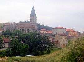
Chirassimont
Chirassimont is a commune in the Loire department in central France.
Chirassimont | |
|---|---|
Commune | |
 | |
Location of Chirassimont 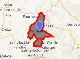
| |
 Chirassimont  Chirassimont | |
| Coordinates: 45°54′52″N 4°17′10″E | |
| Country | France |
| Region | Auvergne-Rhône-Alpes |
| Department | Loire |
| Arrondissement | Roanne |
| Canton | Le Coteau |
| Intercommunality | Pays entre Loire et Rhône |
| Government | |
| • Mayor (2014–2020) | Jean-Paul Jusselme |
| Area 1 | 10.69 km2 (4.13 sq mi) |
| Population (2017-01-01)[1] | 400 |
| • Density | 37/km2 (97/sq mi) |
| Time zone | UTC+01:00 (CET) |
| • Summer (DST) | UTC+02:00 (CEST) |
| INSEE/Postal code | 42063 /42114 |
| Elevation | 469–764 m (1,539–2,507 ft) (avg. 540 m or 1,770 ft) |
| 1 French Land Register data, which excludes lakes, ponds, glaciers > 1 km2 (0.386 sq mi or 247 acres) and river estuaries. | |
Population
| Year | Pop. | ±% |
|---|---|---|
| 1793 | 1,720 | — |
| 1806 | 1,569 | −8.8% |
| 1821 | 1,999 | +27.4% |
| 1831 | 2,062 | +3.2% |
| 1841 | 2,275 | +10.3% |
| 1851 | 1,155 | −49.2% |
| 1861 | 1,205 | +4.3% |
| 1872 | 1,159 | −3.8% |
| 1881 | 1,036 | −10.6% |
| 1891 | 919 | −11.3% |
| 1901 | 897 | −2.4% |
| 1911 | 849 | −5.4% |
| 1921 | 770 | −9.3% |
| 1931 | 765 | −0.6% |
| 1946 | 697 | −8.9% |
| 1954 | 642 | −7.9% |
| 1962 | 649 | +1.1% |
| 1968 | 581 | −10.5% |
| 1975 | 516 | −11.2% |
| 1982 | 417 | −19.2% |
| 1990 | 409 | −1.9% |
| 1999 | 364 | −11.0% |
| 2005 | 382 | +4.9% |
| 2015 | 405 | +6.0% |
gollark: To make a tier 2 void ore miner you have to make a tier 1 void ore miner to run it for a bit to get erodium crystals.
gollark: The tiering is especially poor.
gollark: It *works* perfectly but all the machines just do one very specific task boringly.
gollark: It's just not interestingly designed.
gollark: Environmental Tech is such a bad mod and I resent it being part of progression.
See also
| Wikimedia Commons has media related to Chirassimont. |
| Authority control |
|
|---|
- "Populations légales 2017". INSEE. Retrieved 6 January 2020.
This article is issued from Wikipedia. The text is licensed under Creative Commons - Attribution - Sharealike. Additional terms may apply for the media files.