Vernonia Municipal Airport
Vernonia Municipal Airport (FAA LID: 05S) is a city-owned, public-use airport located two nautical miles (3.7 km) west of the central business district of Vernonia, a city in Columbia County, Oregon, United States.[1]
Vernonia Municipal Airport | |||||||||||
|---|---|---|---|---|---|---|---|---|---|---|---|
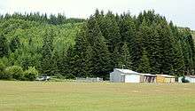 Grass runway, planes, and hangars | |||||||||||
| Summary | |||||||||||
| Airport type | Public | ||||||||||
| Owner | City of Vernonia | ||||||||||
| Serves | Vernonia, Oregon | ||||||||||
| Elevation AMSL | 647 ft / 197 m | ||||||||||
| Coordinates | 45°51′05″N 123°14′29″W | ||||||||||
| Runways | |||||||||||
| |||||||||||
| Statistics (2007) | |||||||||||
| |||||||||||
Facilities and aircraft
Vernonia Municipal Airport covers an area of 47 acres (19 ha) at an elevation of 647 feet (197 m) above mean sea level. It has one runway designated 9/27 with a turf surface measuring 2,940 by 45 feet (896 x 14 m).[1]
For the 12-month period ending February 12, 2007, the airport had 3,000 general aviation aircraft operations, an average of 250 per month. At that time there were 5 aircraft based at this airport, all single-engine.[1]
gollark: > If we’re gonna have this cancerous discussion, then there’s a theory that homosexuality is actual selected for, as a way to reduce how quickly we approach the environmental carrying capacityLike I said, natural selection doesn't exactly optimize for what's best for the *group*.
gollark: I mean, we *are* born with... brain things... which make us susceptible *to* belief in god.
gollark: I'm putting "wants" in quotes because evolution isn't an agent and doesn't literally "want" anything.
gollark: Duckduckgo it.
gollark: While I don't think "does evolution 'want' this" is the same thing as "is this good", if homosexuality was *really* bad for everyone it presumably would have been "evolved out" a while ago.
References
- FAA Airport Master Record for 05S (Form 5010 PDF). Federal Aviation Administration. Effective 8 April 2010.
External links
- Aerial image as of 30 July 2000 from USGS The National Map
- Resources for this airport:
- FAA airport information for 05S
- AirNav airport information for 05S
- FlightAware airport information and live flight tracker
- SkyVector aeronautical chart for 05S
This article is issued from Wikipedia. The text is licensed under Creative Commons - Attribution - Sharealike. Additional terms may apply for the media files.