Ashland Municipal Airport
Ashland Municipal Airport (Sumner Parker Field) (IATA: AHM[2], FAA LID: S03) is two miles east of Ashland, in Jackson County, Oregon.[1] The National Plan of Integrated Airport Systems for 2011 through 2015 categorized it as a general aviation facility.[3]
Ashland Municipal Airport Sumner Parker Field | |||||||||||
|---|---|---|---|---|---|---|---|---|---|---|---|
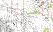 orthophoto of Ashland Municipal Airport | |||||||||||
| Summary | |||||||||||
| Airport type | Public | ||||||||||
| Owner | City of Ashland | ||||||||||
| Serves | Ashland, Oregon | ||||||||||
| Elevation AMSL | 1,885 ft / 575 m | ||||||||||
| Coordinates | 42°11′25″N 122°39′38″W | ||||||||||
| Map | |||||||||||
 S03 | |||||||||||
| Runways | |||||||||||
| |||||||||||
| Statistics (2012) | |||||||||||
| |||||||||||
Facilities
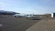
Ashland Municipal Airport runway
The airport covers 94 acres (38 ha) at an elevation of 1,885 feet (575 m). Its one runway, 12/30, is 3,603 by 75 feet (1,098 x 23 m).[1]
In the year ending April 10, 2012 the airport had 26,050 aircraft operations, average 71 per day: 94% general aviation, 6% air taxi, and <1% military. 62 aircraft were then based at the airport: 79% single-engine, 8% helicopter, 6.5% multi-engine, and 6.5% ultralight.[1]
gollark: I don't understand why, but adding a snippet of the page text to each thing appears to make the search query about 100 times slower.
gollark: Oh, never mind, ts_rank_cd is just bad and I can do fine without that.
gollark: How exciting. The search can be fast iff I don't actually have any ranking functions whatsoever.
gollark: This is... odd, why is it not doing an optimized index scan?
gollark: I only have 10000 pages, this should really be trivial to search.
References
- FAA Airport Master Record for S03 (Form 5010 PDF). Federal Aviation Administration. Effective May 31, 2012.
- "Airline and Airport Code Search (AHM: Sumner Parker Field, Ashland)". International Air Transport Association (IATA). Retrieved September 27, 2012.
- "2011–2015 NPIAS Report, Appendix A" (PDF). National Plan of Integrated Airport Systems. Federal Aviation Administration. October 4, 2010. Archived from the original (PDF, 2.03 MB) on 2012-09-27.
External links
- Aerial image as of August 1994 from USGS The National Map
- Resources for this airport:
- FAA airport information for S03
- AirNav airport information for S03
- FlightAware airport information and live flight tracker
- SkyVector aeronautical chart for S03
This article is issued from Wikipedia. The text is licensed under Creative Commons - Attribution - Sharealike. Additional terms may apply for the media files.