Portland–Troutdale Airport
Portland–Troutdale Airport (IATA: TTD, ICAO: KTTD, FAA LID: TTD) is a public use airport located 10 nautical miles (12 mi; 19 km) east of the central business district of Portland, in Multnomah County, Oregon, United States.[1] Also known as Troutdale Airport, it is located in Troutdale. It is one of three airports in the Portland metropolitan area owned and operated by the Port of Portland.[2] It is included in the Federal Aviation Administration (FAA) National Plan of Integrated Airport Systems for 2017–2021, in which it is categorized as a regional general aviation facility.[3]
Portland–Troutdale Airport | |||||||||||
|---|---|---|---|---|---|---|---|---|---|---|---|
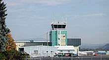 Control tower | |||||||||||
| Summary | |||||||||||
| Airport type | Public | ||||||||||
| Owner | Port of Portland | ||||||||||
| Serves | Portland, Oregon | ||||||||||
| Location | Troutdale, Oregon | ||||||||||
| Elevation AMSL | 39 ft / 12 m | ||||||||||
| Coordinates | 45°32′58″N 122°24′04″W | ||||||||||
| Website | TTD Home | ||||||||||
| Maps | |||||||||||
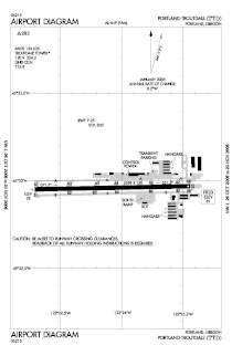 Airport Diagram | |||||||||||
 TTD Location of airport in Oregon / United States  TTD TTD (the United States) | |||||||||||
| Runways | |||||||||||
| |||||||||||
| Statistics | |||||||||||
| |||||||||||
The airport was purchased by the Port of Portland in 1942, serving as a reliever airport for nearby Portland International Airport (PDX) until the 1950s. Troutdale Airport serves as a base for one full fixed-base operator (FBO), several limited FBOs, flight schools, and aircraft repair and maintenance facilities. It is also a popular base for scenic aerial tours of the Columbia River Gorge and recreational flying.[2]
Operations at times may be limited or restricted as Portland International Airport take-off and approach paths cross directly above Troutdale Airport.
Facilities and aircraft
Portland–Troutdale Airport covers an area of 284 acres (115 ha) at an elevation of 39 feet (12 m) above mean sea level. It has one runway designated 7/25 with an asphalt surface measuring 5,399 by 150 feet (1,646 m × 46 m).[1]
For the 12-month period ending September 27, 2017, the airport had 105,020 aircraft operations, an average of 288 per day: 95% general aviation, 4% air taxi, and 1% military. In January 2018, there were 38 aircraft based at this airport: 33 single-engine, 2 multi-engine, and 3 helicopter.[1]
See also
References
- FAA Airport Master Record for TTD (Form 5010 PDF). Federal Aviation Administration. effective January 4, 2018.
- Troutdale Airport, official site
- "List of NPIAS Airports" (PDF). FAA.gov. Federal Aviation Administration. 21 October 2016. Retrieved January 20, 2018.
External links
- Troutdale Airport, official site
- Envi Adventures
- Aerial photo as of 31 May 2002 from USGS The National Map
- FAA Airport Diagram (PDF), effective July 16, 2020
- FAA Terminal Procedures for TTD, effective July 16, 2020
- Resources for this airport:
- FAA airport information for TTD
- AirNav airport information for KTTD
- ASN accident history for TTD
- FlightAware airport information and live flight tracker
- NOAA/NWS weather observations: current, past three days
- SkyVector aeronautical chart, Terminal Procedures