Upper Charles River Reservation
The Upper Charles River Reservation is a Massachusetts state park encompassing portions of the banks of the Charles River between the Watertown Dam in Watertown and Riverdale Park in Dedham and the West Roxbury neighborhood of Boston.[2] The park is managed by the Massachusetts Department of Conservation and Recreation. It includes land in the communities of Watertown, Waltham, Newton, Weston, Wellesley, Needham, Dedham, and Boston. Some of the Charles River Reservation Parkways also fall within the park boundaries.
| Upper Charles River Reservation | |
|---|---|
_-_DSC09456.JPG) Hemlock Gorge | |
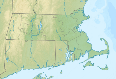 Location in Massachusetts | |
| Location | Watertown, Newton, Waltham, Weston, Wellesley, Needham, West Roxbury, Dedham, Suffolk, Middlesex, Norfolk, Massachusetts, United States |
| Coordinates | 42°16′20″N 71°10′28″W[1] |
| Elevation | 85 ft (26 m)[1] |
| Established | 1890s[2] |
| Governing body | Massachusetts Department of Conservation and Recreation |
| Website | Upper Charles River Reservation |
| Part of a series on |
| Dedham, Massachusetts |
|---|
 |
| History |
| People |
|
| Places |
| Organizations |
| Businesses |
| Education |
See also
References
- "Riverdale Park". Geographic Names Information System. United States Geological Survey.
- "Upper Charles River Reservation". MassParks. Executive Office of Energy and Environmental Affairs. Retrieved February 8, 2014.
External links
- Upper Charles River Reservation Department of Conservation and Recreation
- Upper Charles River Reservation Map (West) Department of Conservation and Recreation
- Upper Charles River Reservation Map (East) Department of Conservation and Recreation
| |||||||||||||||||
| |||||||||||||||||
| |||||||||||||||||
| |||||||||||||||||
| |||||||||||||||||
| |||||||||||||||||
| |||||||||||||||||
| |||||||||||||||||
This article is issued from Wikipedia. The text is licensed under Creative Commons - Attribution - Sharealike. Additional terms may apply for the media files.