United Nations geoscheme for the Americas
The following is an alphabetical list of countries in the United Nations geoscheme for the Americas grouped by subregion and (if applicable) intermediate region.[1] Note that the continent of North America comprises the intermediate regions of Northern America, Caribbean, and Central America.
| United Nations geoscheme for the Americas | |
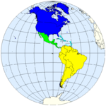 |
Northern America Central America
Caribbean
South America |
Latin America and the Caribbean
Caribbean


.svg.png)


.svg.png)


Central America
Northern America
gollark: Probably.
gollark: I'm okay with not taxing churches or whatever as long as they do not start meddling in politics or operating for profit.
gollark: I suspect this may have happened for many of them.
gollark: You could even genetically engineer plants to work better in the giant farming towers.
gollark: https://www.smbc-comics.com/comics/1571749891-20191022.png
See also
References
- "UNSD — Methodology". unstats.un.org. Retrieved 17 June 2019.
This article is issued from Wikipedia. The text is licensed under Creative Commons - Attribution - Sharealike. Additional terms may apply for the media files.