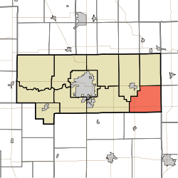
Union Township, Howard County, Indiana
Union Township is one of eleven townships in Howard County, Indiana, United States. As of the 2010 census, its population was 1,029 and it contained 419 housing units.[2]
Union Township | |
|---|---|
 Location in Howard County | |
| Coordinates: 40°26′25″N 85°54′47″W | |
| Country | United States |
| State | Indiana |
| County | Howard |
| Government | |
| • Type | Indiana township |
| Area | |
| • Total | 25.83 sq mi (66.9 km2) |
| • Land | 25.8 sq mi (67 km2) |
| • Water | 0.03 sq mi (0.08 km2) 0.12% |
| Elevation | 850 ft (259 m) |
| Population (2010) | |
| • Total | 1,029 |
| • Estimate (2012[1]) | 1,032 |
| • Density | 39.9/sq mi (15.4/km2) |
| GNIS feature ID | 0453918 |
History
Union Township was organized in 1853.[3]
Geography
| Historical population | |||
|---|---|---|---|
| Census | Pop. | %± | |
| 2000 | 1,056 | — | |
| 2010 | 1,029 | −2.6% | |
| Est. 2012 | 1,032 | 0.3% | |
| U.S. Census[4] | |||
According to the 2010 census, the township has a total area of 25.83 square miles (66.9 km2), of which 25.8 square miles (67 km2) (or 99.88%) is land and 0.03 square miles (0.078 km2) (or 0.12%) is water.[2]
Unincorporated towns
(This list is based on USGS data and may include former settlements.)
Adjacent townships
- Jackson Township (north)
- Sims Township, Grant County (northeast)
- Green Township, Grant County (east)
- Wildcat Township, Tipton County (south)
- Taylor Township (west)
- Liberty Township (northwest)
Cemeteries
The township contains three cemeteries: Jerome, New Hope and Union Civil.
Airports and landing strips
- Hall Airport
- Howard County Airport
gollark: Testbot is written in IDIOMATIC javascriptoids.
gollark: APIONET is an IRC network which exists* and bridges to many places.
gollark: It is bridged to many places.
gollark: Well, APIONET is an IRC network.
gollark: It *intermittently* does.
References
- "Population Estimates". United States Census Bureau. Archived from the original on June 17, 2013. Retrieved 2013-06-25.
- "Population, Housing Units, Area, and Density: 2010 - County -- County Subdivision and Place -- 2010 Census Summary File 1". United States Census. Archived from the original on 2020-02-12. Retrieved 2013-05-10.
- "Howard County's Townships and Their Early Settlements and Towns". Kokomo-Howard County Public Library. Archived from the original on 22 December 2013. Retrieved 2 June 2014.
- "US Census Data". US Government Census Agency. Archived from the original on 8 October 2014. Retrieved 26 February 2014.
This article is issued from Wikipedia. The text is licensed under Creative Commons - Attribution - Sharealike. Additional terms may apply for the media files.