U.S. Route 54 in Kansas
U.S. Route 54 (US-54) is a part of the U.S. Highway System that runs from from El Paso, Texas, to Interstate 72 (I-72) in Griggsville, Illinois. In the U.S. state of Kansas, US-54 is a main east–west highway that runs from the Oklahoma border east to the Missouri border.
| ||||
|---|---|---|---|---|
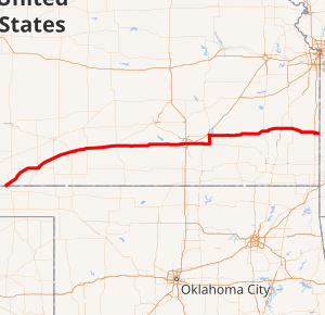
US-54 highlighted in red | ||||
| Route information | ||||
| Maintained by KDOT | ||||
| Major junctions | ||||
| West end | ||||
| East end | ||||
| Highway system | ||||
| ||||

Route description

US 54 enters the state from Oklahoma in Seward County, and travels through the cities of Liberal and Plains, where it runs concurrently with US 160 in Meade County. Just east of the city of Meade, US 54 splits from US 160 and continues in a northeasterly direction through Meade and Ford counties before beginning a long concurrency with US 400 in Mullinville in Kiowa County.
The highway then travels through the town of Greensburg and continues as a two-lane road through Pratt, Cunningham, and Kingman. At Pratt, the Union Pacific railroad tracks which paralleled the highway for over 600 miles (970 km) from El Paso turn to the northeast (towards Topeka) and leave US 54. The road becomes a divided highway in eastern Kingman County. From Kingman to Garden Plain in Sedgwick County it is a freeway but becomes an at-grade expressway as it passes through Goddard and approaches Wichita.

The freeway resumes as the road crosses the city limits of Wichita near Wichita Dwight D. Eisenhower National Airport. In Wichita, US 54/US 400 is known as Kellogg Avenue, and has junctions with I-235, I-135 and I-35, the Kansas Turnpike, before a junction with K-96. The Kellogg Avenue freeway has six lanes and extends 15 miles (24 km) from 111th Street on the west side of Wichita to Zelta just after the I-35/Kansas Turnpike interchange on the east side. Upgrading of Kellogg Avenue from a surface arterial to a freeway has been underway since the mid-1980s, with the latest interchange project opening in late 2019. The road gets its name from Milo Bailey Kellogg, a shopkeeper and Civil War veteran who was the city's first civilian postmaster in 1870.
The concurrency of US 54 and US 400 continues through Augusta in Butler County before US 400 heads east toward the Missouri state line, while US 54 forms a brief concurrency with US 77 through El Dorado. At El Dorado, US 54 continues its easterly course through rural areas in Greenwood and Woodson counties before passing through the cities of Iola and Fort Scott; US 77 heads north to Junction City. US 54 exits Kansas in Bourbon County before reaching Nevada, Missouri.
Future
The state is studying a northwestern bypass of Wichita, which would redesignate K-254 as US-54. [1]
Major intersections
| County | Location | mi[2] | km | Destinations | Notes |
|---|---|---|---|---|---|
| Seward | | 0.000 | 0.000 | Continuation into Oklahoma | |
| Liberal | Western terminus of US-270 | ||||
| Meade | | Western end of US-160 overlap | |||
| Meade | |||||
| Eastern end of US-160 overlap | |||||
| | Eastern terminus of K-98 | ||||
| Clark | Minneola | ||||
| Ford | | Northern terminus of K-94 | |||
| | |||||
| Kiowa | | Western end of US-400 overlap | |||
| | |||||
| Pratt | Pratt | ||||
| | Southern terminus of K-61 | ||||
| Kingman | | Southern terminus of K-11 | |||
| Kingman | Western end of K-14 overlap | ||||
| | Eastern end of K-14 overlap | ||||
| Sedgwick | | Southern terminus of K-251 | |||
| | I-235 exit 7 | ||||
| | I-135 exit | ||||
| | To I-35/Kansas Turnpike exit 50 | ||||
| | Eastern terminus of K-96; to I-35/Kansas Turnpike exit 53 | ||||
| Butler | | Western end of US-77 overlap | |||
| | Western end of US-400 overlap | ||||
| | Eastern end of US-77 overlap; eastern terminus of K-254 | ||||
| | Southern terminus of K-177 | ||||
| Greenwood | | Western end of K-99 overlap | |||
| | Eastern end of K-99 overlap | ||||
| Woodsun | Yates Center | ||||
| Allen | | ||||
| Moran | |||||
| Bourbon | | Western end of K-3 overlap | |||
| | Eastern end of K-3 overlap | ||||
| | Western end of K-7 overlap | ||||
| | Western end of US-69 overlap | ||||
| | Eastern end of US-69/K-7 overlap | ||||
| | Continuation into Missouri | ||||
1.000 mi = 1.609 km; 1.000 km = 0.621 mi
| |||||
References
- "KSDOT Project K-254".
- Staff (2016). "Pavement Management Information System". Kansas Department of Transportation. Retrieved April 21, 2017.