South Carolina Highway 300
South Carolina Highway 300 (SC 300) is an 11.5-mile-long (18.5 km) state highway in the U.S. state of South Carolina. The highway connects Ulmer with the Barnwell area.
| ||||
|---|---|---|---|---|
| ||||
| Route information | ||||
| Maintained by SCDOT | ||||
| Length | 11.46 mi[1] (18.44 km) | |||
| Major junctions | ||||
| West end | ||||
| East end | ||||
| Location | ||||
| Counties | Barnwell, Allendale | |||
| Highway system | ||||
| ||||

Route description
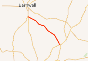
SC 300 begins at an intersection with U.S. Route 301 (US 301; Burton's Ferry Highway) in Ulmer, within Allendale County. It travels to the north-northwest and immediately leaves the city limits. It crosses over Well Branch into Barnwell County and parallels Caddins Branch. The highway travels to the northwest and crosses over Parker Branch and Hurricane Creek. A short distance later, it meets its northern terminus, an intersection with US 278 at a point south of Barnwell.[2]
Major intersections
| County | Location | mi[1] | km | Destinations | Notes |
|---|---|---|---|---|---|
| Barnwell | | 0.00 | 0.00 | ||
| Allendale | Ulmer | 11.46 | 18.44 | ||
| 1.000 mi = 1.609 km; 1.000 km = 0.621 mi | |||||
gollark: I would find it cool™ if you could use rare and exotic words somehow.
gollark: I'll seize the means of production, for profit.
gollark: I WILL monetize communism.
gollark: Anyway, I would be excited to participate in your word market ~~and do high frequency trading~~ so notify me of progress and/or if you need help please.
gollark: ... rollbacking?
See also


References
- "Statewide Highways (shapefile)" (zip). South Carolina Department of Transportation. September 29, 2017. Retrieved December 8, 2017.
- Google (May 13, 2016). "South Carolina Highway 300" (Map). Google Maps. Google. Retrieved May 13, 2016.
External links

- SC 300 South Carolina Hwy Index
This article is issued from Wikipedia. The text is licensed under Creative Commons - Attribution - Sharealike. Additional terms may apply for the media files.