Trafalgar, Indiana
Trafalgar is a town in Nineveh and Hensley townships, Johnson County, Indiana, United States. The population was 1,101 at the 2010 census.
Trafalgar, Indiana | |
|---|---|
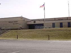
 Indian Creek High School in Trafalgar | |
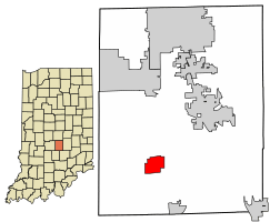
 Location of Trafalgar in Johnson County, Indiana. | |
| Coordinates: 39°24′51″N 86°9′12″W | |
| Country | United States |
| State | Indiana |
| County | Johnson |
| Township | Nineveh, Hensley |
| Area | |
| • Total | 2.56 sq mi (6.63 km2) |
| • Land | 2.56 sq mi (6.63 km2) |
| • Water | 0.00 sq mi (0.00 km2) |
| Elevation | 827 ft (252 m) |
| Population | |
| • Total | 1,101 |
| • Estimate (2019)[3] | 1,345 |
| • Density | 525.39/sq mi (202.87/km2) |
| Time zone | UTC-5 (Eastern (EST)) |
| • Summer (DST) | UTC-4 (EDT) |
| ZIP code | 46181 |
| Area code(s) | 317 |
| FIPS code | 18-76310[4] |
| GNIS feature ID | 0444851[5] |
This town is 20 miles (32 km) south of Indianapolis.
It is the home of the transmitters for WTTV, WTTS, WFCI-FM and WHZN.
History
Col. Avery M. Buckner is credited for platting a town, in the early 1850s, along a short-lived flat bar railroad that ran between Franklin, and Martinsville. First named Liberty, the name was changed to Trafalgar. Soon Ezekiel W. Morgan came to town to open a store. Denied a site near the railroad, he bought land in a nearby village founded by George Bridges.
In 1868, the railroad was rebuilt as the Fairland and Martinsville branch of the Big Four. The post office (and town name) was moved to Morgan's store. By 1870, the “old” and “new” Trafalgars had grown together and were briefly incorporated as one. The current town of Trafalgar was reincorporated in 1946. By the 90s, the town had grown 266%. The name of the town commemorates the Battle of Trafalgar.[6]
Geography
Trafalgar is located at 39°24′51″N 86°9′12″W (39.414126, -86.153291).[7]
According to the 2010 census, Trafalgar has a total area of 2.64 square miles (6.84 km2), all land.[8]
Education
It is within the Nineveh-Hensley-Jackson United School Corporation.[9] Trafalgar is home to Indian Creek Senior High School, one of seven high schools located in Johnson County. It is also home to Indian Creek Middle School and Indian Creek Elementary School.
Trafalgar has a public library, a branch of the Johnson County Public Library.[10]
Demographics
| Historical population | |||
|---|---|---|---|
| Census | Pop. | %± | |
| 1880 | 462 | — | |
| 1950 | 439 | — | |
| 1960 | 459 | 4.6% | |
| 1970 | 457 | −0.4% | |
| 1980 | 466 | 2.0% | |
| 1990 | 531 | 13.9% | |
| 2000 | 798 | 50.3% | |
| 2010 | 1,101 | 38.0% | |
| Est. 2019 | 1,345 | [3] | 22.2% |
| U.S. Decennial Census[11] | |||
2010 census
As of the 2010 census, the town had 1,101 people that comprised 385 households and 292 families. The population density was 417.0 inhabitants per square mile (161.0/km2).[2] There were 419 housing units at an average density of 158.7 per square mile (61.3/km2). The racial makup of the town was 96.3% White, 0.9% African American, 0.9% Native American, 0.5% Asian, 0.3% from other races, and 1.1% from two or more races. Hispanic or Latino of any race were 1.0% of the population.
Of the 385 households 46.8% had children under the age of 18 living with them, 54.3% were married couples living together, 14.8% had a female householder with no husband present, 6.8% had a male householder with no wife present, and 24.2% were non-families. 20.0% of households were one person and 6.5% were one person aged 65 or older. The average household size was 2.83 and the average family size was 3.24.
The median age in the town was 34.2 years. 30.2% of residents were under the age of 18; 9.2% were between the ages of 18 and 24; 28.8% were from 25 to 44; 23.5% were from 45 to 64; and 8.2% were 65 or older. The gender makeup of the town was 49.3% male and 50.7% female.
2000 census
At the 2000 census there were 798 people, 263 households, and 208 families in the town. The population density was 619.2 people per square mile (238.8/km2). There were 286 housing units at an average density of 221.9 per square mile (85.6/km2). The racial makup of the town was 98.75% White, 0.63% Native American, 0.50% Asian, and 0.13% from two or more races. Hispanic or Latino of any race were 0.88%.[4]
Of the 263 households 52.1% had children under the age of 18 living with them, 63.9% were married couples living together, 11.8% had a female householder with no husband present, and 20.9% were non-families. 18.3% of households were one person and 5.7% were one person aged 65 or older. The average household size was 2.99 and the average family size was 3.39.
The age distribution was 35.2% under the age of 18, 7.1% from 18 to 24, 36.3% from 25 to 44, 12.9% from 45 to 64, and 8.4% 65 or older. The median age was 30 years. For every 100 females, there were 95.1 males. For every 100 females age 18 and over, there were 98.1 males.
The median household income was $50,357 and the median family income was $54,531. Males had a median income of $38,438 versus $22,083 for females. The per capita income for the town was $17,079. About 3.5% of families and 8.4% of the population were below the poverty line, including 10.3% of those under age 18 and 9.7% of those age 65 or over.
Notable person
- Elmer S. Riggs, paleontologist
References
- "2019 U.S. Gazetteer Files". United States Census Bureau. Retrieved July 16, 2020.
- "U.S. Census website". United States Census Bureau. Retrieved 2012-12-11.
- "Population and Housing Unit Estimates". United States Census Bureau. May 24, 2020. Retrieved May 27, 2020.
- "U.S. Census website". United States Census Bureau. Retrieved 2008-01-31.
- "US Board on Geographic Names". United States Geological Survey. 2007-10-25. Retrieved 2008-01-31.
- Baker, Ronald L. (October 1995). From Needmore to Prosperity: Hoosier Place Names in Folklore and History. Indiana University Press. p. 326. ISBN 978-0-253-32866-3.
The present name comes from the British naval victory...
- "US Gazetteer files: 2010, 2000, and 1990". United States Census Bureau. 2011-02-12. Retrieved 2011-04-23.
- "G001 - Geographic Identifiers - 2010 Census Summary File 1". United States Census Bureau. Archived from the original on 2020-02-13. Retrieved 2015-07-25.
- "SCHOOL DISTRICT REFERENCE MAP (2010 CENSUS): Johnson County, IN." U.S. Census Bureau. Retrieved on December 5, 2016.
- "Locations and hours". Johnson County Public Library. Retrieved 8 March 2018.
- "Census of Population and Housing". Census.gov. Retrieved June 4, 2015.
.jpg)