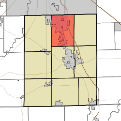
Pleasant Township, Johnson County, Indiana
Pleasant Township is one of nine townships in Johnson County, Indiana. As of the 2010 census, its population was 52,957 and it contained 22,355 housing units.[3]
Pleasant Township | |
|---|---|
 | |
| Coordinates: 39°35′04″N 86°05′13″W | |
| Country | United States |
| State | Indiana |
| County | Johnson |
| Government | |
| • Type | Indiana township |
| Area | |
| • Total | 35.29 sq mi (91.4 km2) |
| • Land | 35.27 sq mi (91.3 km2) |
| • Water | 0.02 sq mi (0.05 km2) |
| Elevation | 820 ft (250 m) |
| Population (2010) | |
| • Total | 52,957 |
| • Density | 1,501.4/sq mi (579.7/km2) |
| FIPS code | 18-60390[2] |
| GNIS feature ID | 453746 |
Pleasant Township was organized in 1829.[4]
Geography
According to the 2010 census, the township has a total area of 35.29 square miles (91.4 km2), of which 35.27 square miles (91.3 km2) (or 99.94%) is land and 0.02 square miles (0.052 km2) (or 0.06%) is water.[3]
gollark: - also the cubes, I guess
gollark: Well, various possibilities exist:- add "exist again" after "exit the zzcxz" - this could take you to a new area with more doors or something- somehow add a mysterious button on the wall of one of the halls which switches the door to osmarks.net mode (somehow²)- "go in an anomalous direction" (or somehow "go up"/"go down") in the initial room- in the bee room, one series of choices could allow access to it- the "sandy ground" area after going backward
gollark: Yes, that is what I was wondering.
gollark: Hmm, where would it actually go? I guess I could repurpose one of the doors.
gollark: Other osmarks.net server room™ possibilities: loud VRRRRRRRRR noises (unless it's liquid-cooled); blinky lights; maintenance robots; tunnels running to other places (with network cables).
References
- "US Board on Geographic Names". United States Geological Survey. 2007-10-25. Retrieved 2008-01-31.
- "U.S. Census website". United States Census Bureau. Retrieved 2008-01-31.
- "Population, Housing Units, Area, and Density: 2010 - County -- County Subdivision and Place -- 2010 Census Summary File 1". United States Census. Archived from the original on 2020-02-12. Retrieved 2013-05-10.
- Banta, David Demaree (1881). A Historical Sketch of Johnson County, Indiana. J.H. Beers & Company. p. 73.
This article is issued from Wikipedia. The text is licensed under Creative Commons - Attribution - Sharealike. Additional terms may apply for the media files.