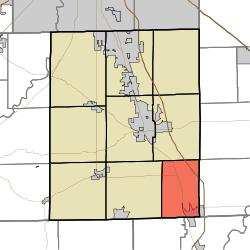
Blue River Township, Johnson County, Indiana
Blue River Township is one of nine townships in Johnson County, Indiana. As of the 2010 census, its population was 4,936 and it contained 2,096 housing units.[3]
Blue River Township | |
|---|---|
 | |
| Coordinates: 39°23′26″N 85°59′30″W | |
| Country | United States |
| State | Indiana |
| County | Johnson |
| Government | |
| • Type | Indiana township |
| Area | |
| • Total | 24.44 sq mi (63.3 km2) |
| • Land | 24.28 sq mi (62.9 km2) |
| • Water | 0.16 sq mi (0.4 km2) |
| Elevation | 709 ft (216 m) |
| Population (2010) | |
| • Total | 4,936 |
| • Density | 203.3/sq mi (78.5/km2) |
| FIPS code | 18-06094[2] |
| GNIS feature ID | 453120 |
History
The Furnas Mill Bridge was listed on the National Register of Historic Places in 2001.[4]
Geography
According to the 2010 census, the township has a total area of 24.44 square miles (63.3 km2), of which 24.28 square miles (62.9 km2) (or 99.35%) is land and 0.16 square miles (0.41 km2) (or 0.65%) is water.[3]
gollark: But only the specific prophets they authorize?
gollark: By its author, I mean.
gollark: I did a project on its early origins one time, I think it was created or at least manipulated for political gain a **lot**.
gollark: Ummm... a monotheistic religion with prophets.
gollark: You didn't answer whether I was apparently now a prophet. Honestly...
References
- "US Board on Geographic Names". United States Geological Survey. 2007-10-25. Retrieved 2008-01-31.
- "U.S. Census website". United States Census Bureau. Retrieved 2008-01-31.
- "Population, Housing Units, Area, and Density: 2010 - County -- County Subdivision and Place -- 2010 Census Summary File 1". United States Census. Archived from the original on 2020-02-12. Retrieved 2013-05-10.
- "National Register Information System". National Register of Historic Places. National Park Service. July 9, 2010.
This article is issued from Wikipedia. The text is licensed under Creative Commons - Attribution - Sharealike. Additional terms may apply for the media files.