Tollet
Tollet is a municipality in the district of Grieskirchen in the Austrian state of Upper Austria.
Tollet | |
|---|---|
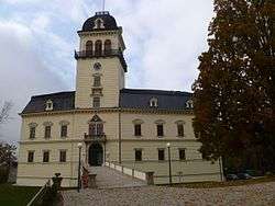 Castle | |
 Coat of arms | |
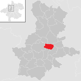 Location in the district | |
 Tollet Location within Austria | |
| Coordinates: 48°14′44″N 13°48′02″E | |
| Country | Austria |
| State | Upper Austria |
| District | Grieskirchen |
| Government | |
| • Burgermeisterin | Dagmar Holter (ÖVP) |
| Area | |
| • Total | 9.55 km2 (3.69 sq mi) |
| Elevation | 381 m (1,250 ft) |
| Population (2018-01-01)[2] | |
| • Total | 920 |
| • Density | 96/km2 (250/sq mi) |
| Time zone | UTC+1 (CET) |
| • Summer (DST) | UTC+2 (CEST) |
| Postal code | 4710 |
| Area code | 07248 |
| Vehicle registration | GR |
| Website | www.tollet.at |
Geography
Tollet lies in the Hausruckviertel. About 18 percent of the municipality is forest, and 72 percent is farmland.
gollark: !pingwhen online <@!258639553357676545> Rust.
gollark: ratemylife.com2018 Copyright. All Rights Reserved.The Sponsored Listings displayed above are served automatically by a third party. Neither the service provider nor the domain owner maintain any relationship with the advertisers. In case of trademark issues please contact the domain owner directly (contact information can be found in whois).Privacy Policy
gollark: See, this is the main thing making Rust great - the ability to easily come up with pun-ish names.
gollark: The shell is called `ion`, is it not?
gollark: Can it run a RuST compiler yet?
References
- "Dauersiedlungsraum der Gemeinden Politischen Bezirke und Bundesländer - Gebietsstand 1.1.2018". Statistics Austria. Retrieved 10 March 2019.
- "Einwohnerzahl 1.1.2018 nach Gemeinden mit Status, Gebietsstand 1.1.2018". Statistics Austria. Retrieved 9 March 2019.
| Wikimedia Commons has media related to Tollet. |
This article is issued from Wikipedia. The text is licensed under Creative Commons - Attribution - Sharealike. Additional terms may apply for the media files.