Tocsin, Indiana
Tocsin is an unincorporated community in Lancaster Township, Wells County, in the U.S. state of Indiana.[3] It is on the border with Jefferson Township.
Tocsin, Indiana | |
|---|---|
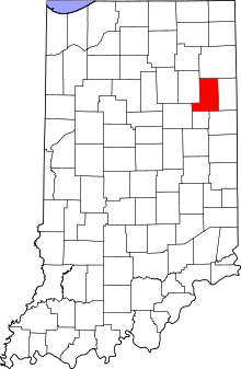 Wells County's location in Indiana | |
 Tocsin Location of Tocsin in Wells County | |
| Coordinates: 40°49′49″N 85°06′33″W | |
| Country | United States |
| State | Indiana |
| County | Wells |
| Township | Lancaster |
| Elevation | 833 ft (254 m) |
| Time zone | UTC-5 (Eastern (EST)) |
| • Summer (DST) | UTC-4 (EDT) |
| ZIP code | 46777 |
| Area code(s) | 260 |
| FIPS code | 18-76076[2] |
| GNIS feature ID | 444793 |
History
Tocsin was platted in 1884.[4] A post office was established at Tocsin in 1882, and remained in operation until it was discontinued in 1966.[5]
Geography
Tocsin is located at 40°49′49″N 85°06′33″W.
gollark: It would have been nice if we ended up with P2P 802.11whatever (WiFi) instead of Bluetooth, since at least then there would be fewer protocols to deal with.
gollark: Mostly I do actually have to think before typing things, so typing speed isn't a *terrible* concern.
gollark: I can type 100WPM or so on my laptop's keyboard, and really slowly on my phone even with the autospellcorrection.
gollark: I really just want a cuboid with a 5"-diagonal display with a sensibly low-resolution rectangular LCD screen (or a smaller one with a keyboard or something, like BlackBerry's keyone stuff), enough thickness to fit in a few days of battery life, swappable batteries (maybe even two), GNU/Linux support, headphone jacks and other important IO (maybe a USB-C and USB-A port), and µSD card support.
gollark: And notches, weird curvey screens you can't put in cases easily, overlarge screens, sort of thing.
References
- "US Board on Geographic Names". United States Geological Survey. 2007-10-25. Retrieved 2008-01-31.
- "U.S. Census website". United States Census Bureau. Retrieved 2008-01-31.
- "Tocsin, Indiana". Geographic Names Information System. United States Geological Survey. Retrieved July 24, 2017.
- Baker, Ronald L. (October 1995). From Needmore to Prosperity: Hoosier Place Names in Folklore and History. Indiana University Press. p. 233. ISBN 978-0-253-32866-3.
The village was platted on August 19, 1884...
- "Wells County". Jim Forte Postal History. Retrieved July 7, 2016.
Municipalities and communities of Wells County, Indiana, United States | ||
|---|---|---|
| City | Map of Indiana highlighting Wells County | |
| Towns | ||
| Townships | ||
| Unincorporated communities | ||
| Footnotes | ‡This populated place also has portions in an adjacent county or counties | |
This article is issued from Wikipedia. The text is licensed under Creative Commons - Attribution - Sharealike. Additional terms may apply for the media files.