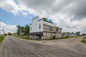
Mount Zion, Indiana
Mount Zion is an unincorporated community in Jackson Township, Wells County, in the U.S. state of Indiana.[3]
Mount Zion, Indiana | |
|---|---|
 | |
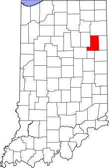 Wells County's location in Indiana | |
 Mount Zion Location of Mount Zion in Wells County | |
| Coordinates: 40°39′01″N 85°20′05″W | |
| Country | United States |
| State | Indiana |
| County | Wells |
| Township | Jackson |
| Elevation | 863 ft (263 m) |
| Time zone | UTC-5 (Eastern (EST)) |
| • Summer (DST) | UTC-4 (EDT) |
| ZIP code | 46792 |
| FIPS code | 18-51786[2] |
| GNIS feature ID | 439724 |
History
A post office was established at Mount Zion in 1873, and remained in operation until it was discontinued in 1917.[4] The community took its name from the nearby Mount Zion Church.[5]
Geography
Mount Zion is located at 40°39′01″N 85°20′05″W.
gollark: There are alternate userspace OOM killers around now.
gollark: In my experience, the OOM killer won't activate unless it's absolutely impossible to keep things working (e.g. by swapping ridiculous amounts) without it doing so.
gollark: Some kernel thing imploded and a process which periodically uses `nvidia-smi` to get GPU usage statistics kept creating new `nvidia-smi` processes.
gollark: Ah, it was, as it turns out, somehow Nvidia drivers.
gollark: Especially since CPU usage is fine.
References
- "US Board on Geographic Names". United States Geological Survey. October 25, 2007. Retrieved 2016-07-07.
- "U.S. Census website". United States Census Bureau. Retrieved 2008-01-31.
- "Mount Zion, Indiana". Geographic Names Information System. United States Geological Survey. Retrieved July 24, 2017.
- "Wells County". Jim Forte Postal History. Retrieved July 7, 2016.
- Baker, Ronald L. (October 1995). From Needmore to Prosperity: Hoosier Place Names in Folklore and History. Indiana University Press. p. 231. ISBN 978-0-253-32866-3.
The name is for a church around which the village was built.
Municipalities and communities of Wells County, Indiana, United States | ||
|---|---|---|
| City | Map of Indiana highlighting Wells County | |
| Towns | ||
| Townships | ||
| Unincorporated communities | ||
| Footnotes | ‡This populated place also has portions in an adjacent county or counties | |
This article is issued from Wikipedia. The text is licensed under Creative Commons - Attribution - Sharealike. Additional terms may apply for the media files.