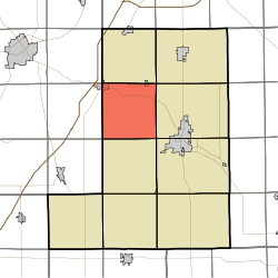
Rockcreek Township, Wells County, Indiana
Rockcreek Township is one of nine townships in Wells County, Indiana, United States. As of the 2010 census, its population was 1,579 and it contained 645 housing units.[2]
Rockcreek Township | |
|---|---|
 Location in Wells County | |
| Coordinates: 40°46′48″N 85°16′43″W | |
| Country | United States |
| State | Indiana |
| County | Wells |
| Government | |
| • Type | Indiana township |
| Area | |
| • Total | 35.91 sq mi (93.0 km2) |
| • Land | 35.57 sq mi (92.1 km2) |
| • Water | 0.34 sq mi (0.9 km2) 0.95% |
| Elevation | 820 ft (250 m) |
| Population (2010) | |
| • Total | 1,579 |
| • Density | 44.4/sq mi (17.1/km2) |
| Time zone | UTC-5 (Eastern (EST)) |
| • Summer (DST) | UTC-4 (EDT) |
| ZIP codes | 46714, 46750, 46770, 46791 |
| Area code(s) | 260 |
| GNIS feature ID | 453811 |
Geography
According to the 2010 census, the township has a total area of 35.91 square miles (93.0 km2), of which 35.57 square miles (92.1 km2) (or 99.05%) is land and 0.34 square miles (0.88 km2) (or 0.95%) is water.[2]
Unincorporated towns
(This list is based on USGS data and may include former settlements.)
Adjacent townships
- Union Township (north)
- Jefferson Township (northeast)
- Lancaster Township (east)
- Harrison Township (southeast)
- Liberty Township (south)
- Salamonie Township, Huntington County (southwest)
- Rock Creek Township, Huntington County (west)
- Union Township, Huntington County (northwest)
Cemeteries
The township contains these three cemeteries: Horeb, Sparks and Spider Hill.
Rivers
School districts
- Northern Wells Community Schools
Political districts
- Indiana's 6th congressional district
- State House District 82
- State Senate District 19
gollark: I assumed you were talking about religion there initially given the phrasing, which I do consider to involve horrible punishment for dubious ethical reasons. But in general it seems to basically just mean "punishment", with connotations of "in accordance with some allegedly fair procedure(s)".
gollark: Secularly, people generally mean "punish people" when they talk about justice as far as I can tell.
gollark: Well, religiously, "justice" seems to mostly be "eternally torturing people".
gollark: I mean, I suppose you can define it that way, but then it becomes a less useful concept and OH BEE HE HAS COME HERE
gollark: "Justice" in that context always seems to involve "horribly punishing people", for dubiously ethical reasons.
References
- United States Census Bureau 2007 TIGER/Line Shapefiles
- United States Board on Geographic Names (GNIS)
- IndianaMap
- History of Rockcreek High School, Rockcreek Township
- "US Board on Geographic Names". United States Geological Survey. October 25, 2007. Retrieved 2017-05-09.
- "Population, Housing Units, Area, and Density: 2010 - County -- County Subdivision and Place -- 2010 Census Summary File 1". United States Census. Archived from the original on 2020-02-12. Retrieved 2013-05-10.
This article is issued from Wikipedia. The text is licensed under Creative Commons - Attribution - Sharealike. Additional terms may apply for the media files.