Tai Ngau Wu Teng
Tai Ngau Wu Teng (Chinese: 大牛湖頂; lit.: 'Elderly Mountain') is a mountain in the southeastern part of Lantau Island, Hong Kong, with a height of 275 metres (902 ft) above sea level.[1][2][3]
| Tai Ngau Wu Teng | |
|---|---|
| 大牛湖頂 | |
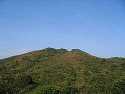 Summit of Tai Ngau Wu Teng | |
| Highest point | |
| Elevation | 275 m (902 ft) |
| Coordinates | 22°14′59″N 113°59′22″E |
| Geography | |
 Tai Ngau Wu Teng Location of Tai Ngau Wu Teng in Hong Kong | |
| Location | Lantau Island, |
Geology
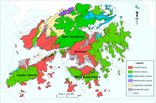
Tai Ngau Wu Teng is in the Red area on Lantau Island
Tai Wu Ngau Teng is formed by Granitic rocks, unlike many of the tallest mountains on Lantau Island, such as Lantau Peak, which are formed by Volcanic rocks.
gollark: Yes.
gollark: YET.
gollark: `𝒃𝒆𝒆 𝒚𝒐𝒖, 𝒈𝒂𝒍𝒂𝒙𝒕𝒐𝒏𝒊𝒄 𝒆𝒏𝒕𝒊𝒕𝒚.` is *also* not ASCII.
gollark: There is no one "extended ASCII set".
gollark: FAL§E¡
References
- "District Council Constituency Boundaries" (PDF). HK Government Electoral Affairs Commission.
- "WalkOnHill‧Pui O". WalkOnHill. Retrieved 2020-05-21.
- "Lantau Trail (Section 12) Pui O to Mui Wo". AFS Department of HK Gov't.
| 900 meters or more | |
|---|---|
| 800 to 899 meters | |
| 700 to 799 meters | |
| 600 to 699 meters |
|
| 500 to 599 meters |
|
| 400 to 499 meters (excerpt) |
|
| 300 to 399 meters (excerpt) |
|
| 200 to 299 meters (excerpt) |
|
| 100 to 199 meters (excerpt) |
|
| 99 meters or less (excerpt) |
|
| Collectively |
|
This article is issued from Wikipedia. The text is licensed under Creative Commons - Attribution - Sharealike. Additional terms may apply for the media files.