Chiu Keng Wan Shan
Chiu Keng Wan Shan (Chinese: 照鏡環山) is a hill that lies between the communities of Yau Tong and Tiu Keng Leng, Hong Kong.
| Chiu Keng Wan Shan | |
|---|---|
| 照鏡環山 | |
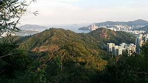 Chiu Keng Wan Shan (left) and Devil's Peak viewed from Black Hill, Hong Kong | |
| Highest point | |
| Elevation | 247 m (810 ft) |
| Coordinates | 22°18′0.17″N 114°14′45.56″E |
| Geography | |
 Chiu Keng Wan Shan Location of Chiu Keng Wan Shan in Hong Kong | |
| Location | |
Geography
Chiu Keng Wan Shan is 247m in height.[1] To the south lies another hill called Devil's Peak.[2] Junk Bay Chinese Permanent Cemetery is built on the east side of Chiu Keng Wan Shan.
Right of middle lies Chiu Keng Wan Shan. Left of middle are the three main peaks of Black Hill. On the far right, Devil's Peak can be seen
Access
Parts of Wilson Trail Section 3 is built along the foot of Chiu Keng Wan Shan on the west side. It is possible to access the summit of Chiu Keng Wan Shan after walking up from O King Road,[3] which is a road that runs between Chiu Keng Wan Shan and nearby Black Hill.
gollark: Nope, most can't, trilateration would need 1285712894 modems.
gollark: I mean, your spammer probably produces predictable packets so you could just discard them.
gollark: It won't "die" but get spammed, beeoid.
gollark: True, true.
gollark: As it is, it'll just do basically nothing.
See also
References
- "Ch5 Analysis of The Hong Kong Landscape". www.pland.gov.hk. Retrieved 7 September 2019.
- "Fun in Kwun Tong - Wilson Trail (Stage 3)". www.kwuntong.org.hk. Retrieved 7 September 2019.
- "Mau Wu Shan‧Oasistrek". www.oasistrek.com. Retrieved 7 September 2019.
External links
| Wikimedia Commons has media related to Chiu Keng Wan Shan. |
| 900 meters or more | |
|---|---|
| 800 to 899 meters | |
| 700 to 799 meters | |
| 600 to 699 meters |
|
| 500 to 599 meters |
|
| 400 to 499 meters (excerpt) |
|
| 300 to 399 meters (excerpt) |
|
| 200 to 299 meters (excerpt) |
|
| 100 to 199 meters (excerpt) |
|
| 99 meters or less (excerpt) |
|
| Collectively |
|
This article is issued from Wikipedia. The text is licensed under Creative Commons - Attribution - Sharealike. Additional terms may apply for the media files.