Keung Shan
Keung Shan (Chinese: 羗山, literally "Ginger Mountain") is a peak in Hong Kong, on southwestern Lantau Island, with a height of 459 metres (1,506 ft) above sea level.[1]
| Keung Shan | |
|---|---|
| 羗山 | |
Summit of Keung Shan | |
| Highest point | |
| Elevation | 459 m (1,506 ft) |
| Coordinates | 22°13′55″N 113°52′53″E |
| Geography | |
 Keung Shan Location of Keung Shan in Hong Kong | |
| Location | Lantau Island, |
Geology

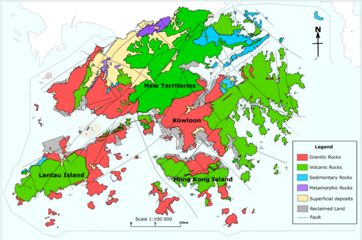
Geological map of Hong Kong showing the distribution of faults and different rock types in Hong Kong. Keung Shan is in the Green area (Volcanic Rock) on Lantau Island
Keung Shan is formed by Volcanic rocks, including porphyritic rhyolites,[2] similar to nearby Lantau Peak and Sunset Peak.
Access
The Lantau Trail traverses the summit of this hill.[3]
gollark: This is really very awful control flow and I do not like it.
gollark: This seems like very bees design.
gollark: Well, where OD I TUP them?!?!?
gollark: Perhaps it is rewrite-in-JS time.
gollark: Oh, I kind of get it, for some bizarre reason the system is invoking the checks on the command...while generating the help.
References
- "Node: Keung Shan (1107726531)". OpenStreetMap. Retrieved 2020-06-24.
- "Lantau Volcanic Group (undifferentiated) - Jlu". www.cedd.gov.hk. Retrieved 2020-04-26.
- "Lantau South". www.afcd.gov.hk. Retrieved 2020-06-24.
This article is issued from Wikipedia. The text is licensed under Creative Commons - Attribution - Sharealike. Additional terms may apply for the media files.