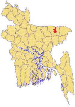
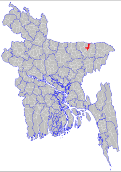
Sunamganj Sadar Upazila
Sunamganj Sadar (Bengali: সুনামগঞ্জ সদর) is an Upazila of Sunamganj District in the Division of Sylhet, Bangladesh.[2]
Sunamganj Sadar সুনামগঞ্জ সদর | |
|---|---|
 | |
 | |
| Coordinates: 25°04′N 91°24′E | |
| Division | Sylhet Division |
| District | Sunamganj District |
| Government | |
| • MPs (Sunamganj-3, Sunamganj-4) | Alhaj Motiur Rahman (4-AL), MA Mannan (3-AL) |
| Area | |
| • Total | 268.61 km2 (103.71 sq mi) |
| Population (2011) | |
| • Total | 279,019[1] |
| Demonym(s) | Sunamganji, Shunamgonji, Shunamgoinji, Sunamgonji |
| Time zone | UTC+6 (BST) |
| Postal code | 3000 |
| Website | www |
Geography
Sunamganj Sadar is located at 25°04′N 91°24′E. Geographically, it is situated on the northeastern part of Bangladesh. It has 50664 households and total area 268.61 km².[2] It is the meeting place of three different upazilas. People are comparatively rich here and love fashion. Also It is placed near the bank of the Surma which is the longest river of Bangladesh. This area has mineral resources like natural gas, mineral oil, raw material for industries, crops, fish and so on. "Tanguar haor" has been included the world heritage site which has thousand species of bird, fish, reptiles and so on are living together. Every year many Bangladeshi and foreign tourists, researchers, nature-lovers, etc. visit.
Union Parishads
The upazila has nine Union Parishads or UPs. They are as follow:
- Kathoir
- Gourarang
- Lakkansree
- Mohonpur
- Mollah Para
- Rangar Char
- Kurban Nagar / Aptabnagar
- Surma
- Jahangirnagar
Demographics
As of 1991 Bangladesh census, Sunamganj Sadar has a population of 303,153. Males constitute 51.27% of the population, and females 48.73%. This Upazila's eighteen up population is 153046. Sunamganj Sadar has an average literacy rate of 23.9% (7+ years), and the national average of 32.4% literate.[3] Religions: Muslim 65%, Hindu 35%, Christian 2%, Buddhist 0.72%, and others 0.28%
Based on 2001 census, the population of the upazila is approximately 367,230, with males constituting 51.32% of the population and, females 48.68% of the population (a drop of 0.5% since 1991). There are 401 villages present, with total households of 8,341, there are 236 mauzas, 14 unions, 44 mahallahs, and 9 wards. The total literacy rate for both females and males is 35.3%, an increase of 2.9% since 2001.[4]
Sunamganj Sadar
- Mollapara UP is a model union in Sunamganj Sadar
Technology
The city of Sunamganj is now being developed in different areas like technology, education, improvement of living system though it was far away from the modern technology. For instance, except few people, nobody knows how can use an internet or just making a phone call. However, nowadays, many residents use modern technology instead without formal education. There are five first class international standard mobile phone company like Grameen phone and Banglalink. and national mobile phone company Teletalk has been installing communication tower, BTS, and related to its even every place from city to rural areas. This area is becoming the most probable business sector for mobile companies to make a business. Now everyone has at least a mobile phone even he or she is worker. In addition, these communication companies are offering competitive call rates and data bonus. On the other hand, every school, college or madrasa are offering computer education. Besides, most of the coaching centers are also bestowing the basic introduction to English with computers in the city.
Notable people
- Hason Raja, musician, mystic poet, philosopher
- Dewan Mohammad Azraf, teacher, author, politician, journalist, philosopher
See also
- Sunamganj
- Upazilas of Bangladesh
- Districts of Bangladesh
- Divisions of Bangladesh
References
- http://www.citypopulation.de/php/bangladesh-admin.php?adm2id=9089
- Alok Ghosh Chowdhury (2012). "Sunamganj Sadar Upazila". In Islam, Sirajul; Miah, Sajahan; Khanam, Mahfuza; Ahmed, Sabbir (eds.). Banglapedia: the National Encyclopedia of Bangladesh (Online ed.). Dhaka, Bangladesh: Banglapedia Trust, Asiatic Society of Bangladesh. ISBN 984-32-0576-6. OCLC 52727562. Retrieved 15 August 2020.
- "Population Census Wing, BBS". Archived from the original on 2005-03-27. Retrieved November 10, 2006.
- Area, Population and Literacy Rate by Upazila/Thana-2001 Archived 2007-07-04 at the Wayback Machine Bangladesh Bureau of Statistics
Capital: Sunamganj | ||
| Upazilas | ||
| Constituencies | ||
| Attractions and sites | ||
| Rivers | ||
| Inhabited areas | ||
| Educational institutions | ||
| Transport | ||
| History | ||
Capital: Sylhet | ||
| Habiganj District |  | |
| Moulvibazar District | ||
| Sunamganj District | ||
| Sylhet District | ||