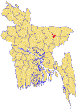
Sullah Upazila
Sullah (Bengali: শাল্লা) or Sulla[1] is an Upazila of Sunamganj District in the Division of Sylhet, Bangladesh.
Sullah শাল্লা | |
|---|---|
 | |
| Division | Sylhet Division |
| District | Sunamganj District |
| Government | |
| • MP (Sunamganj-2) | Joya Sengupta (Awami League) |
| • Ex-MP (Sunamganj-2) | Suranjit Sengupta |
| Area | |
| • Total | 260.74 km2 (100.67 sq mi) |
| Population | |
| • Total | 89,941 |
| • Density | 340/km2 (890/sq mi) |
| Demonym(s) | Sullawi, Shallawi |
| Time zone | UTC+6 (BST) |
| Postal code | 3000 |
Etymology
Sullah is variant of Shah Ullah, which was named after its founder, Shah Ullah. Locally, it is pronounced and written as Shal'lah.
Geography
Sullah is located at 24.6264°N 91.2500°E . It has 13881 households and total area 260.74 km².
Demographics
As of the 1991 Bangladesh census, Sullah has a population of 89941. Males constitute 51.08% of the population, and females 48.92%. This Upazila's eighteen up population is 43247. Sullah has an average literacy rate of 21.8% (7+ years), and the national average of 32.4% literate.[2] It has a large Hindu population with over 50% of the upazila.
Administration
Sullah has 4 Unions/Wards, 67 Mauzas/Mahallas, and 113 villages.
gollark: It's an attempt to wrest prizes from those who aren't stupidly rich.
gollark: ```Hoop Snake can fly and crawl fine, but he would much rather move by grasping his tail in his jaws and rolling around like a wheel. He looks extremely silly but can also move terrifyingly fast, but that is only because he manipulates time so viewers think he's wheeling faster and more gracefully than he really is. He's really a strange dragon with a head full of tall tales. His greatest adversaries are trees, which he tends to clumsily impale while rolling around the forest.```
gollark: https://dragcave.net/view/75cUc
gollark: Ah, yes, I have a child from that.
gollark: *goes to Bad Ideas, where TJ09 gets all suggestions from*
See also
- Upazilas of Bangladesh
- Districts of Bangladesh
- Divisions of Bangladesh
References
- Jiban Kumar Chanda (2012). "Sulla Upazila". In Sirajul Islam and Ahmed A. Jamal (ed.). Banglapedia: National Encyclopedia of Bangladesh (Second ed.). Asiatic Society of Bangladesh.
- "Population Census Wing, BBS". Archived from the original on 2005-03-27. Retrieved November 10, 2006.
Capital: Sunamganj | ||
| Upazilas | ||
| Constituencies | ||
| Attractions and sites | ||
| Rivers | ||
| Inhabited areas | ||
| Educational institutions | ||
| Transport | ||
| History | ||
Capital: Sylhet | ||
| Habiganj District | 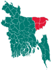 | |
| Moulvibazar District | ||
| Sunamganj District | ||
| Sylhet District | ||
This article is issued from Wikipedia. The text is licensed under Creative Commons - Attribution - Sharealike. Additional terms may apply for the media files.