St. Joseph River (Maumee River tributary)
The St. Joseph River is an 86.1-mile-long (138.6 km)[1] tributary of the Maumee River in northwestern Ohio and northeastern Indiana in the United States, with headwater tributaries rising in southern Michigan. It drains a primarily rural farming region in the watershed of Lake Erie.
| St. Joseph River | |
|---|---|
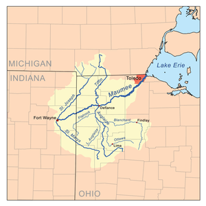 Map of the Maumee River watershed showing the St. Joseph River. | |
| Location | |
| Country | United States |
| Physical characteristics | |
| Source | |
| • location | Hillsdale County, Michigan |
| • coordinates | 41°38′53″N 84°33′56″W |
| • elevation | 856 ft (261 m) |
| Mouth | |
• location | Maumee River, Ft. Wayne, Indiana |
• coordinates | 41°05′00″N 85°07′56″W |
• elevation | 751 ft (229 m) |
| Length | 100 mi (160 km) |
| Basin features | |
| Tributaries | |
| • left | West Branch St. Joseph River |
| • right | East Branch St. Joseph River |
| GNIS ID | 2678706 |
The St. Joseph River of Lake Michigan is an entirely separate river that rises in western Michigan, dips into Indiana, and flows west into Lake Michigan.
Origin
At the end of the Wisconsin glaciation, the glacier's Erie Lobe retreated toward the northeast, leaving large debris deposits called moraines. The St. Joseph formed as a meltwater channel between the north limbs of two of these moraines, the Wabash Moraine on the west and the Fort Wayne Moraine on the east. At that time it joined the St. Marys River to drain into the Wabash River. Later, the shrinkage of Glacial Lake Maumee, the ancestor of modern Lake Erie, brought about the opening of the modern Maumee River, which captured the flow of the St. Joseph and the St. Marys, causing the St. Marys to reverse its course to meet the flow of the St. Joseph almost head-on.
The St. Joseph today
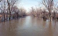
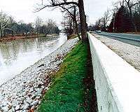
The St. Joseph River forms in northern Williams County, Ohio, at the confluence of the East and West branches at 41°38′54″N 84°33′55″W.[2][3][4] Both branches rise in southern Hillsdale County, Michigan. The headwaters of the East Branch are within 3 miles (4.8 km) of those of the St. Joseph River of Lake Michigan. Both branches initially flow southeast, then turn to the southwest to flow across the northwestern corner of Ohio past Montpelier. The St. Joseph enters De Kalb County in northeastern Indiana, flowing southwest past Saint Joe and into the city of Fort Wayne, where it meets the St. Marys River to form the Maumee River at 41°04′58″N 85°07′56″W.[5] The US Army Corps of Engineers built a flood control project in Fort Wayne that includes a floodwall and upper roadway along the St. Joseph River. (See photo)
Tributaries
From the mouth:
- (left) Becketts Run[6]
- (right) Tiernan Ditch
- (left) Ely Run[7]
- (left) Cedar Creek[8]
- Cedarville Reservoir[9]
- (left) Swartz-Carnahan Ditch[13]
- Dunton Lake[14]
- (right) Boger Ditch[15]
- (left) Metcalf Ditch[16]
- (right) Walker Ditch[17]
- (left) Dilley Ditch[18]
- (left) Wade Ditch[19]
- (left) Bear Creek[20]
- (right) Nancy Davis Ditch
- (left) Sol Shank Ditch[25]
- (right) Melissa Ditch[30]
- (left) Buck Creek[31]
- (left) Christoffel Ditch[36]
- (right) Willow Run[37]
- (right) Amaden Ditch[38]
- (right) Greens Ditch[39]
- (right) Foulks Ditch[40]
- (left) Peter Grube Ditch[41]
- (left) Big Run[42]
- (left) Russell Run[53]
- (left) Fish Creek[54]
- (left) Bluff Run[68]
- (left) Bear Creek[69]
- (left) Tamarack Ditch[70]
- (left) Eagle Creek[71]
- (right) North Branch Eagle Creek[72]
- (left) Nettle Creek[73]
- (right) East Branch St. Joseph River (rises in southwest Adams Township, Hillsdale County, Michigan at 41°54′17″N 84°33′52″W[3])
- (left) West Branch St. Joseph River (rises just south of the intersection of Carpenter Rd. and W. Territorial Rd. in southern Cambria Township, Hillsdale County, Michigan at 41°38′53″N 84°41′24″W[4])
- Lake Seneca[93]
- (left) outflow from Lake La Su An[94]
- (right) East Fork West Branch St. Joseph River (rises in northwest Cambria Township, Hillsdale County, Michigan at 41°51′53″N 84°40′34″W[95])
- (left) West Fork West Branch St. Joseph River (rises from the outflow of Rebeck Lake in northwest Camden Township, Hillsdale County, Michigan at 41°48′22″N 84°48′22″W[107])
- Lake Seneca[93]
Drainage basin
The St. Joseph River and tributaries drain all or portions of the following:
- Allen County, Indiana
- DeKalb County, Indiana
- Auburn
- Butler Township
- Butler
- Concord Township
- Franklin Township
- Garrett
- Jackson Township
- Keyser Township
- Newville Township
- Richland Township
- Grant Township
- Fairfield Township
- Saint Joe
- Smithfield Township
- Spencer Township
- Spencerville
- Stafford Township
- Troy Township
- Union Township
- Waterloo
- Wilmington Township
- Noble County, Indiana
- Steuben County, Indiana
- Defiance County, Ohio
See also
- List of Indiana rivers
- List of Michigan rivers
- List of rivers of Ohio
- USS St. Joseph's River, a World War II era US Navy vessel named after this river.
References
- U.S. Geological Survey. National Hydrography Dataset high-resolution flowline data. The National Map, accessed May 19, 2011
- U.S. Geological Survey Geographic Names Information System: Saint Joseph River
- U.S. Geological Survey Geographic Names Information System: East Branch Saint Joseph River
- U.S. Geological Survey Geographic Names Information System: West Branch Saint Joseph River
- U.S. Geological Survey Geographic Names Information System: Maumee River
- U.S. Geological Survey Geographic Names Information System: Becketts Run
- U.S. Geological Survey Geographic Names Information System: Ely Run
- U.S. Geological Survey Geographic Names Information System: Cedar Creek
- U.S. Geological Survey Geographic Names Information System: Cedarville Reservoir
- U.S. Geological Survey Geographic Names Information System: Nettlehorst Ditch
- U.S. Geological Survey Geographic Names Information System: Wittmer Ditch
- U.S. Geological Survey Geographic Names Information System: Haifley Ditch
- U.S. Geological Survey Geographic Names Information System: Swartz-Carnahan Ditch
- U.S. Geological Survey Geographic Names Information System: Dunton Lake
- U.S. Geological Survey Geographic Names Information System: Boger Ditch
- U.S. Geological Survey Geographic Names Information System: Metcalf Ditch (Allen County)
- U.S. Geological Survey Geographic Names Information System: Walker Ditch
- U.S. Geological Survey Geographic Names Information System: Dilley Ditch
- U.S. Geological Survey Geographic Names Information System: Wade Ditch
- U.S. Geological Survey Geographic Names Information System: Bear Creek
- U.S. Geological Survey Geographic Names Information System: North Branch Hursey Ditch
- U.S. Geological Survey Geographic Names Information System: Carper Ditch
- U.S. Geological Survey Geographic Names Information System: South Branch Hursey Ditch
- U.S. Geological Survey Geographic Names Information System: Swander Ditch
- U.S. Geological Survey Geographic Names Information System: Sol Shank Ditch
- U.S. Geological Survey Geographic Names Information System: Weicht Ditch
- U.S. Geological Survey Geographic Names Information System: Sebert Ditch
- U.S. Geological Survey Geographic Names Information System: Varner Ditch
- U.S. Geological Survey Geographic Names Information System: Hoodelmier Ditch
- U.S. Geological Survey Geographic Names Information System: Melissa Ditch
- U.S. Geological Survey Geographic Names Information System: Buck Creek
- U.S. Geological Survey Geographic Names Information System: Smith Ditch
- U.S. Geological Survey Geographic Names Information System: Mason Ditch
- U.S. Geological Survey Geographic Names Information System: Metcalf Ditch (DeKalb County)
- U.S. Geological Survey Geographic Names Information System: Harwood Ditch
- U.S. Geological Survey Geographic Names Information System: Christoffel Ditch
- U.S. Geological Survey Geographic Names Information System: Willow Run
- U.S. Geological Survey Geographic Names Information System: Amaden Ditch
- U.S. Geological Survey Geographic Names Information System: Greens Ditch
- U.S. Geological Survey Geographic Names Information System: Foulks Ditch
- U.S. Geological Survey Geographic Names Information System: Peter Grube Ditch
- U.S. Geological Survey Geographic Names Information System: Big Run
- U.S. Geological Survey Geographic Names Information System: Ayford Ditch
- U.S. Geological Survey Geographic Names Information System: Walters Ditch
- U.S. Geological Survey Geographic Names Information System: Streeter Ditch
- U.S. Geological Survey Geographic Names Information System: Praul Ditch
- U.S. Geological Survey Geographic Names Information System: Mary Metcalf Ditch
- U.S. Geological Survey Geographic Names Information System: Teutsch Ditch
- U.S. Geological Survey Geographic Names Information System: Donnell Ditch
- U.S. Geological Survey Geographic Names Information System: King Ditch
- U.S. Geological Survey Geographic Names Information System: John Smith Ditch
- U.S. Geological Survey Geographic Names Information System: Haverstolk Ditch
- U.S. Geological Survey Geographic Names Information System: Russell Run
- U.S. Geological Survey Geographic Names Information System: Fish Creek
- U.S. Geological Survey Geographic Names Information System: Cornell Ditch
- U.S. Geological Survey Geographic Names Information System: Hiram Sweet Ditch
- U.S. Geological Survey Geographic Names Information System: Baker Ditch
- U.S. Geological Survey Geographic Names Information System: Hamilton Lake
- U.S. Geological Survey Geographic Names Information System: Black Creek
- U.S. Geological Survey Geographic Names Information System: Haughey Ditch
- U.S. Geological Survey Geographic Names Information System: Lillian Metz Ditch
- U.S. Geological Survey Geographic Names Information System: Burch Ditch
- U.S. Geological Survey Geographic Names Information System: Ball Lake
- U.S. Geological Survey Geographic Names Information System: Myers Ditch
- U.S. Geological Survey Geographic Names Information System: Perfect Lake
- U.S. Geological Survey Geographic Names Information System: West Branch Fish Creek
- U.S. Geological Survey Geographic Names Information System: Donald Nunkle Ditch
- U.S. Geological Survey Geographic Names Information System: Bluff Rub
- U.S. Geological Survey Geographic Names Information System: Bear Creek (Ohio)
- U.S. Geological Survey Geographic Names Information System: Tamarack Ditch
- U.S. Geological Survey Geographic Names Information System: Eagle Creek
- U.S. Geological Survey Geographic Names Information System: North Branch Eagle Creek
- U.S. Geological Survey Geographic Names Information System: Nettle Creek
- U.S. Geological Survey Geographic Names Information System: Nettle Lake
- U.S. Geological Survey Geographic Names Information System: Mill Stream Drain
- U.S. Geological Survey Geographic Names Information System: Clear Fork
- U.S. Geological Survey Geographic Names Information System: Silver Creek
- U.S. Geological Survey Geographic Names Information System: Laird Creek
- U.S. Geological Survey Geographic Names Information System: Nile Ditch
- U.S. Geological Survey Geographic Names Information System: Ransom Ditch
- U.S. Geological Survey Geographic Names Information System: Bird Creek
- U.S. Geological Survey Geographic Names Information System: Bird Lake
- U.S. Geological Survey Geographic Names Information System: Newton Drain
- U.S. Geological Survey Geographic Names Information System: Dillon Drain
- U.S. Geological Survey Geographic Names Information System: Anderson Drain
- U.S. Geological Survey Geographic Names Information System: Goose Creek
- U.S. Geological Survey Geographic Names Information System: Lake Number One
- U.S. Geological Survey Geographic Names Information System: Lake Number Two
- U.S. Geological Survey Geographic Names Information System: Pittsford Millpond
- U.S. Geological Survey Geographic Names Information System: Otto Drain
- U.S. Geological Survey Geographic Names Information System: Deer Lake
- U.S. Geological Survey Geographic Names Information System: Twin Lake
- U.S. Geological Survey Geographic Names Information System: Lake Seneca
- U.S. Geological Survey Geographic Names Information System: Lake La Su An
- U.S. Geological Survey Geographic Names Information System: East Fork West Branch Saint Joseph River
- U.S. Geological Survey Geographic Names Information System: Jonas Brown Drain
- U.S. Geological Survey Geographic Names Information System: Carruthers Drain
- U.S. Geological Survey Geographic Names Information System: Cub Lake
- U.S. Geological Survey Geographic Names Information System: Cambria Millpond
- U.S. Geological Survey Geographic Names Information System: Cambria Drain
- U.S. Geological Survey Geographic Names Information System: Meade Drain
- U.S. Geological Survey Geographic Names Information System: Bear Lake
- U.S. Geological Survey Geographic Names Information System: Pike Lake
- U.S. Geological Survey Geographic Names Information System: Broom Lake
- U.S. Geological Survey Geographic Names Information System: Lake Wilson
- U.S. Geological Survey Geographic Names Information System: Bankers Lake
- U.S. Geological Survey Geographic Names Information System: West Fork West Branch Saint Joseph River
- U.S. Geological Survey Geographic Names Information System: Joe Drain
- U.S. Geological Survey Geographic Names Information System: Prouty Drain
- U.S. Geological Survey Geographic Names Information System: Rebeck Lake
- U.S. Geological Survey Geographic Names Information System: Mead Lake
- U.S. Geological Survey Geographic Names Information System: Turner Lake
Further reading
External links
- EPA St. Joseph Watershed Profile
- St. Joseph River Watershed Initiative
- Maumee River Basin Commission
- Maume Valley Heritage Corridor
| Authority control |
|
|---|