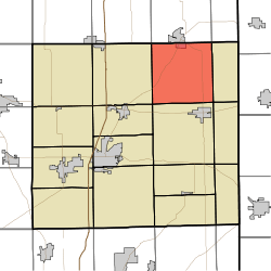
Franklin Township, DeKalb County, Indiana
Franklin Township is one of fifteen townships in DeKalb County, Indiana. As of the 2010 census, its population was 1,182 and it contained 502 housing units.[3]
Franklin Township | |
|---|---|
 Location of Franklin Township in DeKalb County | |
| Coordinates: 41°28′54″N 84°54′22″W | |
| Country | United States |
| State | Indiana |
| County | DeKalb |
| Government | |
| • Type | Indiana township |
| Area | |
| • Total | 35.18 sq mi (91.1 km2) |
| • Land | 35.11 sq mi (90.9 km2) |
| • Water | 0.07 sq mi (0.2 km2) |
| Elevation | 922 ft (281 m) |
| Population (2010) | |
| • Total | 1,182 |
| • Density | 33.7/sq mi (13.0/km2) |
| FIPS code | 18-25342[2] |
| GNIS feature ID | 453300 |
History
Franklin Township was organized in 1837, making it the oldest township in DeKalb County.[4]
Geography
According to the 2010 census, the township has a total area of 35.18 square miles (91.1 km2), of which 35.11 square miles (90.9 km2) (or 99.80%) is land and 0.07 square miles (0.18 km2) (or 0.20%) is water.[3] Terry Lake is in this township.
Cities and towns
- Hamilton (south quarter)
Unincorporated towns
(This list is based on USGS data and may include former settlements.)
Adjacent townships
- Otsego Township, Steuben County (north)
- Richland Township, Steuben County (northeast)
- Troy Township (east)
- Stafford Township (southeast)
- Wilmington Township (south)
- Grant Township (southwest)
- Smithfield Township (west)
- Steuben Township, Steuben County (northwest)
Major highways
Cemeteries
The township contains one cemetery, Rude.
gollark: So the way to defeat SunFish is to push them to the cave, where they will be taken apart by cavegoers and cause a rare drought for years.
gollark: *xenowyrm xenowyrms*
gollark: *works on porting time of death checker to work as a firefox extension*
gollark: I got the weird thing!https://dragcave.net/lineage/MpmwI
gollark: Er... hypothetical AP walls...
References
- "Franklin Township, DeKalb County, Indiana". Geographic Names Information System. United States Geological Survey. Retrieved 2009-09-24.
- United States Census Bureau cartographic boundary files
- "US Board on Geographic Names". United States Geological Survey. 2007-10-25. Retrieved 2008-01-31.
- "U.S. Census website". United States Census Bureau. Retrieved 2008-01-31.
- "Population, Housing Units, Area, and Density: 2010 - County -- County Subdivision and Place -- 2010 Census Summary File 1". United States Census. Archived from the original on 2020-02-12. Retrieved 2013-05-10.
- History of DeKalb County, Indiana: Together with Sketches of Its Cities, Villages and Towns. Inter-State Publishing Company. 1885. pp. 600.
This article is issued from Wikipedia. The text is licensed under Creative Commons - Attribution - Sharealike. Additional terms may apply for the media files.