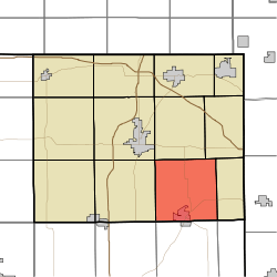
Otsego Township, Steuben County, Indiana
Otsego Township is one of twelve townships in Steuben County, Indiana, United States. As of the 2010 census, its population was 2,575 and it contained 1,839 housing units.[2]
Otsego Township | |
|---|---|
 Location in Steuben County | |
| Coordinates: 41°34′13″N 84°54′40″W | |
| Country | United States |
| State | Indiana |
| County | Steuben |
| Government | |
| • Type | Indiana township |
| Area | |
| • Total | 34.78 sq mi (90.1 km2) |
| • Land | 33.54 sq mi (86.9 km2) |
| • Water | 1.24 sq mi (3.2 km2) 3.57% |
| Elevation | 958 ft (292 m) |
| Population (2010) | |
| • Total | 2,575 |
| • Density | 76.8/sq mi (29.7/km2) |
| Time zone | UTC-5 (Eastern (EST)) |
| • Summer (DST) | UTC-4 (EDT) |
| Area code(s) | 260 |
| GNIS feature ID | 453697 |
Geography
According to the 2010 census, the township has a total area of 34.78 square miles (90.1 km2), of which 33.54 square miles (86.9 km2) (or 96.43%) is land and 1.24 square miles (3.2 km2) (or 3.57%) is water.[2] Lakes in this township include Ball Lake, Fee Lake, Hamilton Lake, Jackson Lake, Johnson Lake and Round Lake. The stream of Black Creek runs through this township.
Cities and towns
- Hamilton (north three-quarters)
Unincorporated towns
- Circle Park at 41.5497727°N 84.9099617°W
- Clarks Landing at 41.5597727°N 84.9116284°W
- Cold Springs at 41.5558838°N 84.9088505°W
- Forest Park at 41.5506061°N 84.9252400°W
- Fountain Park at 41.5631060°N 84.9141285°W
- Island Park at 41.5408838°N 84.9210732°W
- Oakwood at 41.5497727°N 84.9135729°W
- Otsego Center at 41.5725504°N 84.9088504°W
- Penn Park at 41.5442172°N 84.9238511°W
- Ravinia Oaks at 41.5650504°N 84.9010724°W
- Russels Point at 41.5539394°N 84.9241289°W
(This list is based on USGS data and may include former settlements.)
Adjacent townships
- Scott Township (north)
- York Township (northeast)
- Richland Township (east)
- Troy Township, DeKalb County (southeast)
- Franklin Township, DeKalb County (south)
- Smithfield Township, DeKalb County (southwest)
- Steuben Township (west)
- Pleasant Township (northwest)
Cemeteries
The township contains five cemeteries: Carter, Hamilton, North Otsego, Otsego Center and Teegardin.
Major highways
gollark: I have no idea about *that*, but it's not valid to say "12 protests in your area → guaranteed (i.e. 100% or nearly) chance of one or more being violent".
gollark: > 10 percent of BLM protests are violent. that means if you have 12 protests in your area you are guaranteed to be hurt, or have property damageRandom nitpicking, but that is *not* how probabilities work.
gollark: Although, I'm not sure how a "no capital system" is meant to work, given that you need capital to produce basically anything.
gollark: Lots of the things fitting into each category are completely different from each other in other ways.
gollark: But that's not necessarily a *good* dichotomy.
References
- "US Board on Geographic Names". United States Geological Survey. October 25, 2007. Retrieved 2017-05-09.
- "Population, Housing Units, Area, and Density: 2010 - County -- County Subdivision and Place -- 2010 Census Summary File 1". United States Census. Archived from the original on 2020-02-12. Retrieved 2013-05-10.
This article is issued from Wikipedia. The text is licensed under Creative Commons - Attribution - Sharealike. Additional terms may apply for the media files.