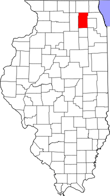
St. Charles Township, Kane County, Illinois
St. Charles Township is one of sixteen townships in Kane County, Illinois, USA. As of the 2010 census, its population was 50,854 and it contained 19,043 housing units.[2]
St. Charles Township | |
|---|---|
 Location in Kane County | |
 Kane County's location in Illinois | |
| Coordinates: 41°56′34″N 88°19′12″W | |
| Country | |
| State | |
| County | Kane |
| Established | November 6, 1849 |
| Area | |
| • Total | 35.55 sq mi (92.1 km2) |
| • Land | 34.82 sq mi (90.2 km2) |
| • Water | 0.74 sq mi (1.9 km2) 2.08% |
| Elevation | 728 ft (222 m) |
| Population (2010) | |
| • Estimate (2016)[1] | 51,672 |
| • Density | 1,460.6/sq mi (563.9/km2) |
| Time zone | UTC-6 (CST) |
| • Summer (DST) | UTC-5 (CDT) |
| ZIP codes | 60119, 60120, 60134, 60174, 60175, 60177, 60184 |
| FIPS code | 17-089-66716 |
Geography
According to the 2010 census, the township has a total area of 35.55 square miles (92.1 km2), of which 34.82 square miles (90.2 km2) (or 97.95%) is land and 0.74 square miles (1.9 km2) (or 2.08%) is water.[2] It is divided by the Fox River.
Cities, towns, villages
- Bartlett (west edge)
- Campton Hills (partial)
- South Elgin (partial)
- St. Charles (vast majority)
- Wayne (west half)
School districts
- Geneva Community Unit School District 304
- School District U-46
- St. Charles Community Unit School District 303
Political districts
- Illinois's 14th congressional district
- State House District 49
- State House District 50
- State House District 55
- State Senate District 25
- State Senate District 28
Notable people
- Lester Frank Ward (1841-1913), sociologist
gollark: Terra did that. I think it's technically lime.
gollark: &kSECRET ENCRYPTED DATA
gollark: MultiMC crashinated.
gollark: PotatOS is really great, I have to say.&7[&aTerraInc&7] &4Terrariola &7: &fI totally agree, I don't know why people dislike it.
gollark: FROGCAT™ by GTech.
References
- "Saint Charles Township, Kane County, Illinois". Geographic Names Information System. United States Geological Survey. Retrieved 2010-06-26.
- United States Census Bureau 2009 TIGER/Line Shapefiles
- United States National Atlas
- "Population and Housing Unit Estimates". Retrieved June 9, 2017.
- "Population, Housing Units, Area, and Density: 2010 - County -- County Subdivision and Place -- 2010 Census Summary File 1". United States Census. Archived from the original on 2020-02-12. Retrieved 2013-05-28.
- "Census of Population and Housing". Census.gov. Retrieved June 4, 2016.
External links
This article is issued from Wikipedia. The text is licensed under Creative Commons - Attribution - Sharealike. Additional terms may apply for the media files.