Hampshire, Illinois
Hampshire is a village in Kane County, Illinois, United States. As of the 2010 census it had a population of 5,563,[4] and as of 2018 the estimated population was 6,324.[5]
Hampshire, Illinois | |
|---|---|
Village | |
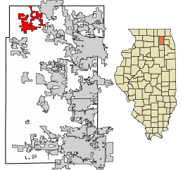
 Location of Hampshire in Kane County, Illinois | |
.svg.png) Location of Illinois in the United States | |
| Coordinates: 42°5′56″N 88°31′33″W | |
| Country | United States |
| State | Illinois |
| County | Kane |
| Townships | Hampshire, Rutland |
| Government | |
| • Village President | Jeff Magnussen[1] |
| Area | |
| • Total | 9.28 sq mi (24.02 km2) |
| • Land | 9.28 sq mi (24.02 km2) |
| • Water | 0.00 sq mi (0.00 km2) |
| Population (2010) | |
| • Total | 5,563 |
| • Estimate (2019)[3] | 6,251 |
| • Density | 673.96/sq mi (260.21/km2) |
| Time zone | UTC-6 (CST) |
| • Summer (DST) | UTC-5 (CDT) |
| ZIP Code(s) | 60140 |
| Area code(s) | 847 |
| FIPS code | 17-32525 |
| Wikimedia Commons | Hampshire, Illinois |
| Website | www |
Geography
Hampshire is located in northwestern Kane County at 42°05′56″N 88°31′33″W.[6] Most of the village is in Hampshire Township, and a small portion extends east into Rutland Township. The village is bordered to the northeast by Huntley and to the southeast by Pingree Grove.
Illinois Route 72 passes through the southern part of the village, leading east 4 miles (6 km) to Starks and west 8 miles (13 km) to Genoa. U.S. Route 20 passes through the northeastern outskirts of the village, leading northwest 13 miles (21 km) to Marengo and southeast 12 miles (19 km) to Elgin. Hampshire is 52 miles (84 km) northwest of the center of Chicago.
According to the 2010 census, Hampshire has a total area of 8.95 square miles (23.18 km2), all land.[7]
Demographics
| Historical population | |||
|---|---|---|---|
| Census | Pop. | %± | |
| 1880 | 483 | — | |
| 1890 | 696 | 44.1% | |
| 1900 | 760 | 9.2% | |
| 1910 | 697 | −8.3% | |
| 1920 | 618 | −11.3% | |
| 1930 | 656 | 6.1% | |
| 1940 | 757 | 15.4% | |
| 1950 | 970 | 28.1% | |
| 1960 | 1,309 | 34.9% | |
| 1970 | 1,611 | 23.1% | |
| 1980 | 1,735 | 7.7% | |
| 1990 | 1,843 | 6.2% | |
| 2000 | 2,900 | 57.4% | |
| 2010 | 5,563 | 91.8% | |
| Est. 2019 | 6,251 | [3] | 12.4% |
| U.S. Decennial Census[8] | |||
As of the 2010 census, there were 5,563 people and 2,031 housing units in Hampshire, a population spike of 91.8% from the 2000 census.
As of the census[9] of 2000, there were 2,490 people, 1,015 households, and 792 families residing in the village. There were 1,051 housing units at an average density of 215.5 per square mile (83.2/km2). The racial makeup of the village was 98.21% White, 0.10% African American, 0.38% Native American, 0.14% Asian, and 0.62% from other races. Hispanic or Latino of any race were 2.41% of the population.
There were 1,015 households, out of which 42.0% had children under the age of 18 living with them, 66.6% were married couples living together, 7.9% had a female householder with no husband present, and 21.9% were non-families. 17.5% of all households were made up of individuals, and 7.6% had someone living alone who was 65 years of age or older. The average household size was 2.86 and the average family size was 3.28.
In the village, the population was spread out, with 29.7% under the age of 18, 6.8% from 18 to 24, 32.1% from 25 to 44, 20.2% from 45 to 64, and 11.3% who were 65 years of age or older. The median age was 35 years. For every 100 females, there were 92.8 males. For every 100 females age 18 and over, there were 89.8 males.
The median income for a household in the village was $58,519, and the median income for a family was $65,069. Males had a median income of $42,217 versus $29,934 for females. The per capita income for the village was $22,143. About 2.3% of families and 2.9% of the population were below the poverty line, including 2.5% of those under age 18 and 9.2% of those age 65 or over.
Education
The Hampshire school system consists of Hampshire High School, Hampshire Middle School, Hampshire Elementary School, and Gary D. Wright Elementary. The high school's mascot is the "Whip-Pur", a cat-like creature whose name derives from the school colors, white and purple.
Notable people
- Charles H. Backus, Illinois state representative and businessman[10]
- Jake Goebbert, former San Diego Padres player, graduate of Hampshire High School
References
- "Elected Officials". Village of Hampshire. Retrieved 2015-08-24.
- "2019 U.S. Gazetteer Files". United States Census Bureau. Retrieved July 14, 2020.
- "Population and Housing Unit Estimates". United States Census Bureau. May 24, 2020. Retrieved May 27, 2020.
- "Geographic Identifiers: 2010 Demographic Profile Data (G001): Hampshire village, Illinois". American Factfinder. U.S. Census Bureau. Retrieved February 8, 2019.
- "Population and Housing Unit Estimates". Retrieved September 14, 2019.
- "US Gazetteer files: 2010, 2000, and 1990". United States Census Bureau. 2011-02-12. Retrieved 2011-04-23.
- "G001 - Geographic Identifiers - 2010 Census Summary File 1". United States Census Bureau. Archived from the original on 2020-02-13. Retrieved 2015-08-03.
- "Census of Population and Housing". Census.gov. Retrieved June 4, 2015.
- "U.S. Census website". United States Census Bureau. Retrieved 2008-01-31.
- 'Illinois Blue Book 1905-1906,' Biographical Sketch of Charles H. Backus, pg. 266-267