Spring Township, Boone County, Illinois
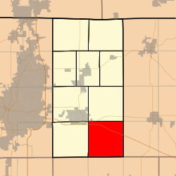
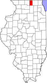
Spring Township is one of nine townships in Boone County, Illinois, USA. As of the 2010 census, its population was 894 and it contained 371 housing units.[2] Spring was founded as "Concord" on November 6, 1849, then was renamed "Ohio" in April, 1851, and finally "Spring" in October, 1851.
Spring Township | |
|---|---|
 Location in Boone County | |
 Boone County's location in Illinois | |
| Coordinates: 42°11′49″N 88°45′25″W | |
| Country | United States |
| State | Illinois |
| County | Boone |
| Settlement | November 6, 1849 |
| Area | |
| • Total | 36.15 sq mi (93.6 km2) |
| • Land | 36.1 sq mi (93 km2) |
| • Water | 0.05 sq mi (0.1 km2) 0.14% |
| Elevation | 860 ft (262 m) |
| Population (2010) | |
| • Estimate (2016)[1] | 877 |
| • Density | 24.8/sq mi (9.6/km2) |
| Time zone | UTC-6 (CST) |
| • Summer (DST) | UTC-5 (CDT) |
| ZIP codes | 60135, 60145, 61008, 61038 |
| FIPS code | 17-007-71578 |
Geography
According to the 2010 census, the township has a total area of 36.15 square miles (93.6 km2), of which 36.1 square miles (93 km2) (or 99.86%) is land and 0.05 square miles (0.13 km2) (or 0.14%) is water.[2]
Cities
- Belvidere (east edge)
Unincorporated towns
Extinct towns
Cemeteries
The township contains Shattucks Grove Cemetery.
Major highways
Airports and landing strips
- Henderson Airport
School districts
- Belvidere Consolidated Unit School District 100
Political districts
- Illinois' 16th congressional district
- State House District 69
- State Senate District 35
gollark: You do, it's in the JS EULA.
gollark: Inδeeδ.
gollark: Not that I agree with use of OOP oriented programming, of course.
gollark: Lua can do that too in a more general way via `__index`.
gollark: No.
References
- "Spring Township, Boone County, Illinois". Geographic Names Information System. United States Geological Survey. Retrieved 2010-01-04.
- United States Census Bureau 2007 TIGER/Line Shapefiles
- United States National Atlas
- "Population and Housing Unit Estimates". Retrieved June 9, 2017.
- "Population, Housing Units, Area, and Density: 2010 - County -- County Subdivision and Place -- 2010 Census Summary File 1". United States Census. Archived from the original on 2020-02-12. Retrieved 2013-05-28.
- "Census of Population and Housing". Census.gov. Retrieved June 4, 2016.
External links
This article is issued from Wikipedia. The text is licensed under Creative Commons - Attribution - Sharealike. Additional terms may apply for the media files.