Caledonia, Illinois
Caledonia is a village in Caledonia Township, Boone County, Illinois, United States. It is part of the Rockford, Illinois Metropolitan Statistical Area. The population was 197 at the 2010 census, down from 199 in 2000.
Caledonia Caledonia Junction | |
|---|---|
Village | |
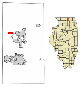
 Location of Caledonia in Boone County, Illinois. | |
.svg.png) Location of Illinois in the United States | |
| Coordinates: 42°22′04″N 88°53′33″W | |
| Country | United States |
| State | Illinois |
| County | Boone |
| Area | |
| • Total | 1.03 sq mi (2.68 km2) |
| • Land | 1.03 sq mi (2.68 km2) |
| • Water | 0.00 sq mi (0.00 km2) 0% |
| Population (2010) | |
| • Total | 197 |
| • Estimate (2019)[2] | 193 |
| • Density | 186.47/sq mi (72.01/km2) |
| Time zone | UTC-6 (CST) |
| • Summer (DST) | UTC-5 (CDT) |
| Area code(s) | 815 |
| FIPS code | 17-10422 |
| Wikimedia Commons | Caledonia, Illinois |
| Website | www |
History
A post office was established as Caledonia Station in 1853, and renamed Caledonia in 1883.[3] Caledonia is a literary name of Scotland.[4]
Caledonia was struck by an EF-2 tornado on November 22, 2010, around 3:04 pm; several homes were destroyed, a grain bin collapsed, the local Elementary school was set on lockdown, and six minor injuries were reported when a bus was blown over near Argyle and Harlem Roads.[5]
Geography
Caledonia is located at 42°22′04″N 88°53′33″W (42.367850, -88.892538).[6]
According to the 2010 census, Caledonia has a total area of 1.01 square miles (2.62 km2), all land.[7]
Demographics
| Historical population | |||
|---|---|---|---|
| Census | Pop. | %± | |
| 1880 | 134 | — | |
| 1890 | 184 | 37.3% | |
| 2000 | 199 | — | |
| 2010 | 197 | −1.0% | |
| Est. 2019 | 193 | [2] | −2.0% |
| U.S. Decennial Census[8] | |||
As of the census[9] of 2000, there were 199 people, 71 households, and 54 families residing in the village. The population density was 373.0 people per square mile (145.0/km2). There were 75 housing units at an average density of 140.6 per square mile (54.6/km2). The racial makeup of the village was 99.8% White. However, population statistics only represent the village, not the surrounding neighborhoods, which include Aberdeen, Aberdeen Knoll, and Inverness.
There were 71 households, out of which 45.1% had children under the age of 18 living with them, 67.6% were married couples living together, 8.5% had a female householder with no husband present, and 23.9% were non-families. 18.3% of all households were made up of individuals, and 11.3% had someone living alone who was 65 years of age or older. The average household size was 2.80 and the average family size was 3.20.
In the village, the population was spread out, with 30.2% under the age of 18, 9.0% from 18 to 24, 32.7% from 25 to 44, 17.1% from 45 to 64, and 11.1% who were 65 years of age or older. The median age was 34 years. For every 100 females, there were 103.1 males. For every 100 females age 18 and over, there were 98.6 males.
Estimated median household income in 2012: $62,172 (it was $51,250 in 2000)

Future development
Caledonia lags behind Poplar Grove in the size of its tax base. Caledonia is approximately three miles east of the new State Highway 173 interchange on Interstate 90, which will position Caledonia to grow its tax base and benefit from increased revenue.
Notable people
- Glenn W. Birkett, Wisconsin State Assemblyman and farmer, was born in Caledonia.[10]
- John Peterson, farmer, performance artist, entrepreneur, owner of Angelic Organics
References
- "2019 U.S. Gazetteer Files". United States Census Bureau. Retrieved July 14, 2020.
- "Population and Housing Unit Estimates". United States Census Bureau. May 24, 2020. Retrieved May 27, 2020.
- "Boone County". Jim Forte Postal History. Retrieved 28 February 2015.
- Chicago and North Western Railway Company (1908). A History of the Origin of the Place Names Connected with the Chicago & North Western and Chicago, St. Paul, Minneapolis & Omaha Railways. p. 50.
- US Department of Commerce, NOAA. "EF-2 Tornado confirmed at Caledonia, IL in Winnebago County". www.weather.gov. Retrieved 2018-12-04.
- "US Gazetteer files: 2010, 2000, and 1990". United States Census Bureau. 2011-02-12. Retrieved 2011-04-23.
- "G001 - Geographic Identifiers - 2010 Census Summary File 1". United States Census Bureau. Archived from the original on 2020-02-13. Retrieved 2015-08-02.
- "Census of Population and Housing". Census.gov. Retrieved June 4, 2015.
- "U.S. Census website". United States Census Bureau. Retrieved 2008-01-31.
- 'Wisconsin Blue Book 1950,' Biographical Sketch of Glenn W. Birkett, pg. 65