Simonds Parish, Saint John County, New Brunswick
Simonds is a civil parish[lower-alpha 1] in Saint John County, New Brunswick, Canada.[2]
Simonds | |
|---|---|
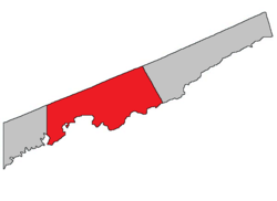 Location within Saint John County; erroneously includes City of Saint John within parish. | |
| Coordinates: 45.33°N 65.78°W | |
| Country | |
| Province | |
| County | Saint John County |
| Established | 1839 |
| Population (2016)[1] | |
| • Total | 3,843 |
| • Change 2011-16 | |
| • Dwellings | 1,483 |
| Time zone | UTC-4 (AST) |
| • Summer (DST) | UTC-3 (ADT) |
| Median Income* | $51,323 CDN |
| |
For governance purposes it is divided between the local service districts of Fairfield and the parish of Simonds.[3]
History
Simonds Parish established in 1839 from Portland Parish: named for James Simonds (1735-1831), the first English settler at Saint John in 1761, and for his son Charles Simonds (1783-1859), the speaker of the New Brunswick house of assembly.
Delineation
Simonds Parish is defined in the Territorial Division Act[2] as being bounded:
- All that part of the County bounded south by the Bay of Fundy, west by The City of Saint John, north by the Kings County line, and east by the eastern line of lot number one, granted to Samuel Hugh, at Tynemouth Creek, and the northern prolongation thereof.
Communities
Parish population total does not include incorporated municipalities (in bold):
|
|
|
Geography
The following water bodies are located within or adjacent to this parish.
- Balls Lake
- Black River
- Browns Lake
- Bay of Fundy (adjacent)
- Grassy Lake
- Haynes Lake
- Loch Lomond
- Mackins Lake
- McBrien Lake
- Millican Lake
- Otter Lake
- Taylor Lake
Demographics
Access Routes
Highways and numbered routes that run through the parish, including external routes that start or finish at the parish limits:[5]
|
|
|
|
See also
Notes
- Civil parishes served a variety of government functions until 1966, when the new Municipalities Act stripped them of their responsibilities; they continue to provide convenient boundaries for government uses, especially electoral districts and local service districts. Statistics Canada uses civil parishes as census subdivisions for all parts of the province that are not within municipalities and similar entities.
References
- "Chapter T-3 Territorial Division Act". Government of New Brunswick. Retrieved 22 July 2020.
- "New Brunswick Regulation 84-168 under the Municipalities Act (O.C. 84-582)". Government of New Brunswick. Retrieved 22 July 2020.
- Statistics Canada: 1986, 1991, 1996, 2001, 2006, 2011, 2016 census
- Atlantic Canada Back Road Atlas ISBN 978-1-55368-618-7
External links
Places adjacent to Simonds Parish, Saint John County, New Brunswick | |
|---|---|
| Subdivisions |
|
|---|---|
| Cities | |
| Counties | |
| |