Saint Martins Parish, New Brunswick
Saint Martins is a civil parish[lower-alpha 1] in Saint John County, New Brunswick, Canada.[2]
Saint Martins St. Martins | |
|---|---|
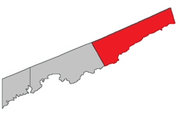 Location within Saint John County. | |
| Coordinates: 45.36°N 65.54°W | |
| Country | |
| Province | |
| County | Saint John County |
| Established | 1786 |
| Area | |
| • Land | 629.20 km2 (242.94 sq mi) |
| Population (2016)[1] | |
| • Total | 1,132 |
| • Density | 1.8/km2 (5/sq mi) |
| • Change 2011-16 | |
| • Dwellings | 609 |
| Time zone | UTC-4 (AST) |
| • Summer (DST) | UTC-3 (ADT) |
| Median Income* | $53,675 CDN |
| |
For governance purposes it is divided between the village of St. Martins and the local service district of the parish of Saint Martins.[3]
History
Saint Martins Parish was established in 1786, and possibly was named for St. Martins in the state of Maryland. It also included part of Alma Parish, Albert County until 1837.
Delineation
Saint Martins Parish is defined in the Territorial Division Act[2] as being bounded:
- All that part of the County lying to the eastward of Simonds Parish.
Communities
Parish population total does not include incorporated municipalities (in bold).
|
|
|
Bodies of water & Islands
This is a list of rivers, lakes, streams, creeks, marshes and Islands that are at least partially in this parish
- Salmon River
- Tynemouth Creek
Demographics
Population
|
LanguageMother tongue (2016)[1]
|
Access Routes
Highways and numbered routes that run through the parish, including external routes that start or finish at the parish limits:[5]
|
|
|
|
See also
Notes
- Civil parishes served a variety of government functions until 1966, when the new Municipalities Act stripped them of their responsibilities; they continue to provide convenient boundaries for government uses, especially electoral districts and local service districts. Statistics Canada uses civil parishes as census subdivisions for all parts of the province that are not within municipalities and similar entities.
References
- "Census Profile, 2016 Census Saint Martins, Parish [Census subdivision], New Brunswick". Statistics Canada. Retrieved September 29, 2019.
- "Chapter T-3 Territorial Division Act". Government of New Brunswick. Retrieved 22 July 2020.
- "New Brunswick Regulation 84-168 under the Municipalities Act (O.C. 84-582)". Government of New Brunswick. Retrieved 22 July 2020.
- Statistics Canada: 1986, 1991, 1996, 2001, 2006, 2011, 2016 census
- Atlantic Canada Back Road Atlas ISBN 978-1-55368-618-7
Places adjacent to Saint Martins Parish, New Brunswick | ||||||||||
|---|---|---|---|---|---|---|---|---|---|---|
| ||||||||||
| Subdivisions |
|
|---|---|
| Cities | |
| Counties | |
| |