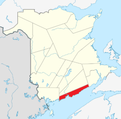
Saint John County, New Brunswick
Saint John County (2016 population: 74,020[1]) is located in southern New Brunswick, Canada. The city of Saint John dominates the county. Elsewhere in the county, tourism is focused around the Bay of Fundy.

Fairfield, New Brunswick
Saint John | |
|---|---|
 Location within New Brunswick. | |
| Coordinates: 45°18′N 66°00′W | |
| Country | |
| Province | |
| Established | 1785 |
| Area | |
| • Land | 1,463.70 km2 (565.14 sq mi) |
| Population (2016)[1] | |
| • Total | 74,020 |
| • Density | 50.6/km2 (131/sq mi) |
| • Change 2011-2016 | |
| • Dwellings | 36,825 |
| Time zone | UTC-4 (AST) |
| • Summer (DST) | UTC-3 (ADT) |
| Area code(s) | 506 |
Census subdivisions
Communities
There are two municipalities within Saint John County (listed by 2016 population):[2]
| Official Name | Designation | Area km2 | Population | Parish |
|---|---|---|---|---|
| Saint John | City | 315.96 | 67,575 | Simonds |
| St. Martins | Village | 2.35 | 276 | Saint Martins |
Parishes
The county is subdivided by the Territorial Division Act (Section 27) into one city and three parishes (listed by 2016 population):[2]
| Official Name | Area km2 | Population | Municipalities | Unincorporated communities |
|---|---|---|---|---|
| Saint John (city) | 315.96 | 67,575 | Saint John (city) | |
| Simonds | 280.86 | 3,843 | Baxters Corner / Black River / Cape Spencer / Coleraine / Fairfield / Gardner Creek / Garnett Settlement / Grove Hill / Lake View Estates / Mispec / Otter Lake / Primrose / Quaco Road / Simonds / Upper Golden Grove / Upper Loch Lomond / West Beach / Willow Grove | |
| Musquash | 235.33 | 1,194 | Chance Harbour / Dam Road / Dipper Harbour East / Dipper Harbour West / Five Fathom Hole / Gilmore Subdivision / Gooseberry Cove / Little Lepreau / Musquash / Point Lepreau / Prince of Wales / Sherwood Road / South Musquash | |
| Saint Martins | 629.20 | 1,132 | St. Martins (village) | Bains Corner / Bay View / Burchills Flats / Chapel Flats / Chester / Drawlin Hill / Fair View / Hardingville / Little Beach / Mosher Hill / Orange Hill / Porter Road / Salmon River / Shanklin / Tynemouth Creek / West Quaco |
Demographics
Population
| Canada census – Saint John County, New Brunswick community profile | |||
|---|---|---|---|
| 2016 | 2011 | 2006 | |
| Population: | 74,020 (-3.3% from 2011) | 76,550 (+2.6% from 2006) | 74,621 (-2.3% from 2001) |
| Land area: | 1,463.70 km2 (565.14 sq mi) | 1,464.53 km2 (565.46 sq mi) | 1,462.03 km2 (564.49 sq mi) |
| Population density: | 50.6/km2 (131/sq mi) | 52.3/km2 (135/sq mi) | 51.0/km2 (132/sq mi) |
| Median age: | 44.1 (M: 42.6, F: 45.5) | 42.3 (M: 40.7, F: 43.8) | 41.1 (M: 39.6, F: 42.4) |
| Total private dwellings: | 36,825 | 36,426 | 34,914 |
| Median household income: | $53,887 | $48,963 | $42,216 |
| References: 2016[2] 2011[3] 2006[4] earlier[5] | |||
|
|
| |||||||||||||||||||||||||||
| [6][1] | |||||||||||||||||||||||||||||
Language
| Canada Census Mother Tongue - Saint John County, New Brunswick[6][1] | ||||||||||||||||||
|---|---|---|---|---|---|---|---|---|---|---|---|---|---|---|---|---|---|---|
| Census | Total | English |
French |
English & French |
Other | |||||||||||||
| Year | Responses | Count | Trend | Pop % | Count | Trend | Pop % | Count | Trend | Pop % | Count | Trend | Pop % | |||||
2016 |
72,645 |
65,645 | 90.1% | 3,075 | 4.2% | 410 | 0.6% | 3,695 | 5.1% | |||||||||
2011 |
75,085 |
68,540 | 91.28% | 3,495 | 4.65% | 320 | 0.43% | 2,730 | 3.64% | |||||||||
2006 |
73,255 |
66,545 | 90.84% | 3,610 | 4.93% | 340 | 0.46% | 2,760 | 3.77% | |||||||||
2001 |
75,195 |
69,575 | 92.53% | 3,765 | 5.01% | 225 | 0.30% | 1,630 | 2.17% | |||||||||
1996 |
77,925 |
72,615 | n/a | 93.19% | 3,650 | n/a | 4.68% | 360 | n/a | 0.46% | 1,300 | n/a | 1.67% | |||||
Access Routes
Highways and numbered routes that run through the county, including external routes that start or finish at the county limits:[7]
Protected areas and attractions
Notable people
gollark: > what do you meaan you don't know?I mean I don't know.
gollark: Oh, yes, that. I don't know how it works.
gollark: You can't upload more.
gollark: All you can do is pick music from my library, which you don't like.
gollark: Why would you want to control OIR, anyway?
See also
References
- "Census Profile, 2016 Census: Saint John, County [Census division], New Brunswick". Statistics Canada. Retrieved September 29, 2019.
- "2016 Community Profiles". 2016 Canadian Census. Statistics Canada. February 21, 2017. Retrieved 2019-09-29.
- "2011 Community Profiles". 2011 Canadian Census. Statistics Canada. July 5, 2013. Retrieved 2014-03-31.
- "2006 Community Profiles". 2006 Canadian Census. Statistics Canada. March 30, 2011. Retrieved 2014-03-31.
- "2001 Community Profiles". 2001 Canadian Census. Statistics Canada. February 17, 2012.
- Statistics Canada: 1996, 2001, 2006, 2011 census
- Atlantic Canada Back Road Atlas ISBN 978-1-55368-618-7
External links
| Wikimedia Commons has media related to Saint John County, New Brunswick. |
This article is issued from Wikipedia. The text is licensed under Creative Commons - Attribution - Sharealike. Additional terms may apply for the media files.