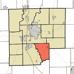
Sand Creek Township, Bartholomew County, Indiana
Sand Creek Township is one of twelve townships in Bartholomew County, Indiana, United States. As of the 2010 census, its population was 2,390 and it contained 919 housing units.[1]
Sand Creek Township | |
|---|---|
 The William R. Gant Farmhouse, a historic site in the township | |
 Location in Bartholomew County | |
| Coordinates: 39°07′17″N 85°50′28″W | |
| Country | United States |
| State | Indiana |
| County | Bartholomew |
| Government | |
| • Type | Indiana township |
| Area | |
| • Total | 26.49 sq mi (68.6 km2) |
| • Land | 26.21 sq mi (67.9 km2) |
| • Water | 0.27 sq mi (0.7 km2) 1.02% |
| Elevation | 630 ft (192 m) |
| Population (2010) | |
| • Total | 2,390 |
| • Density | 91.2/sq mi (35.2/km2) |
| ZIP codes | 47201, 47203, 47232 |
| GNIS feature ID | 0453831 |
History
The Elnora Daugherty Farm, William R. Gant Farm, and Newsom-Marr Farm are listed on the National Register of Historic Places.[2]
Geography
According to the 2010 census, the township has a total area of 26.49 square miles (68.6 km2), of which 26.21 square miles (67.9 km2) (or 98.94%) is land and 0.27 square miles (0.70 km2) (or 1.02%) is water.[1]
Cities, towns, villages
- Elizabethtown
Unincorporated towns
Adjacent townships
- Rock Creek Township (northeast)
- Geneva Township, Jennings County (east)
- Redding Township, Jackson County (south)
- Wayne Township (west)
- Columbus Township (northwest)
Cemeteries
The township contains these three cemeteries: New Harmony, Sandcreek and Springer.
Major highways


School districts
- Bartholomew County School Corporation
Political districts
- Indiana's 9th congressional district
- State House District 57
- State House District 65
- State Senate District 41
gollark: I... may have some pictures stored in a backup somewhere?
gollark: It was quite fun and popular, but broke because of poor performance.
gollark: An old server with a kitchen sink pack.
gollark: Also on Switchcraft.
gollark: It totally exists. On Project Beta 2, which no longer exists.
References
- United States Census Bureau 2007 TIGER/Line Shapefiles
- United States Board on Geographic Names (GNIS)
- United States National Atlas
- "Population, Housing Units, Area, and Density: 2010 - County -- County Subdivision and Place -- 2010 Census Summary File 1". United States Census. Archived from the original on 2020-02-12. Retrieved 2013-05-10.
- "National Register Information System". National Register of Historic Places. National Park Service. July 9, 2010.
This article is issued from Wikipedia. The text is licensed under Creative Commons - Attribution - Sharealike. Additional terms may apply for the media files.