Saint-Pierre, Jura
Saint-Pierre is a commune in the Jura department in the Bourgogne-Franche-Comté region in eastern France.
Saint-Pierre | |
|---|---|
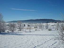 A general view of Saint-Pierre in winter | |
Location of Saint-Pierre 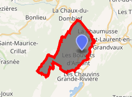
| |
 Saint-Pierre  Saint-Pierre | |
| Coordinates: 46°34′08″N 5°55′11″E | |
| Country | France |
| Region | Bourgogne-Franche-Comté |
| Department | Jura |
| Arrondissement | Saint-Claude |
| Canton | Saint-Laurent-en-Grandvaux |
| Government | |
| • Mayor (2014–2020) | Liliane Faivre |
| Area 1 | 16.37 km2 (6.32 sq mi) |
| Population (2017-01-01)[1] | 342 |
| • Density | 21/km2 (54/sq mi) |
| Time zone | UTC+01:00 (CET) |
| • Summer (DST) | UTC+02:00 (CEST) |
| INSEE/Postal code | 39494 /39150 |
| Elevation | 846–1,135 m (2,776–3,724 ft) |
| 1 French Land Register data, which excludes lakes, ponds, glaciers > 1 km2 (0.386 sq mi or 247 acres) and river estuaries. | |
Population
| Year | Pop. | ±% |
|---|---|---|
| 1793 | 790 | — |
| 1806 | 613 | −22.4% |
| 1821 | 831 | +35.6% |
| 1831 | 808 | −2.8% |
| 1841 | 644 | −20.3% |
| 1851 | 578 | −10.2% |
| 1861 | 502 | −13.1% |
| 1872 | 447 | −11.0% |
| 881 | 405 | −9.4% |
| 1891 | 316 | −22.0% |
| 1901 | 308 | −2.5% |
| 1911 | 226 | −26.6% |
| 1921 | 225 | −0.4% |
| 1931 | 282 | +25.3% |
| 1946 | 212 | −24.8% |
| 1954 | 182 | −14.2% |
| 1962 | 185 | +1.6% |
| 1968 | 163 | −11.9% |
| 1975 | 185 | +13.5% |
| 1982 | 204 | +10.3% |
| 1990 | 239 | +17.2% |
| 1999 | 316 | +32.2% |
| 2008 | 320 | +1.3% |
| 2013 | 326 | +1.9% |
gollark: No.
gollark: Consider this, however.
gollark: Interesting.
gollark: What kind of coordinate system are you using?
gollark: My true political views can only be represented by a 97-dimensional hypercube.
See also
References
- "Populations légales 2017". INSEE. Retrieved 6 January 2020.
| Wikimedia Commons has media related to Saint-Pierre (Jura). |
| Authority control |
|
|---|
This article is issued from Wikipedia. The text is licensed under Creative Commons - Attribution - Sharealike. Additional terms may apply for the media files.