Mignovillard
Mignovillard is a commune in the Jura department in Bourgogne-Franche-Comté in eastern France. On 1 January 2016, the former commune of Communailles-en-Montagne was merged into Mignovillard.[2]
Mignovillard | |
|---|---|
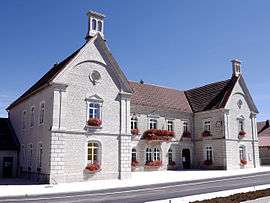 The town hall in Mignovillard | |
 Coat of arms | |
Location of Mignovillard 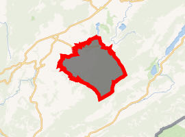
| |
 Mignovillard  Mignovillard | |
| Coordinates: 46°47′29″N 6°07′36″E | |
| Country | France |
| Region | Bourgogne-Franche-Comté |
| Department | Jura |
| Arrondissement | Lons-le-Saunier |
| Canton | Saint-Laurent-en-Grandvaux |
| Government | |
| • Mayor (2014–2020) | Florent Serrette |
| Area 1 | 53.82 km2 (20.78 sq mi) |
| Population (2016-01-01)[1] | 828 |
| • Density | 15/km2 (40/sq mi) |
| Time zone | UTC+01:00 (CET) |
| • Summer (DST) | UTC+02:00 (CEST) |
| INSEE/Postal code | 39331 /39250 |
| Elevation | 799–1,189 m (2,621–3,901 ft) |
| 1 French Land Register data, which excludes lakes, ponds, glaciers > 1 km2 (0.386 sq mi or 247 acres) and river estuaries. | |
Population
| Year | Pop. | ±% |
|---|---|---|
| 1793 | 636 | — |
| 1806 | 656 | +3.1% |
| 1821 | 756 | +15.2% |
| 1831 | 721 | −4.6% |
| 1841 | 770 | +6.8% |
| 1851 | 734 | −4.7% |
| 1861 | 726 | −1.1% |
| 1872 | 699 | −3.7% |
| 1881 | 734 | +5.0% |
| 1891 | 725 | −1.2% |
| 1901 | 680 | −6.2% |
| 1911 | 543 | −20.1% |
| 1921 | 476 | −12.3% |
| 1931 | 497 | +4.4% |
| 1946 | 480 | −3.4% |
| 1954 | 504 | +5.0% |
| 1962 | 511 | +1.4% |
| 1968 | 529 | +3.5% |
| 1975 | 715 | +35.2% |
| 1982 | 662 | −7.4% |
| 1990 | 654 | −1.2% |
| 1999 | 649 | −0.8% |
| 2006 | 640 | −1.4% |
| 2012 | 731 | +14.2% |
gollark: Well, you can't, because it's off.
gollark: You could make it track closer to the terrain and possibly use less processing power by making it only check the stuff roughly under its path.
gollark: So just "go X above highest block in the local area"? That seems simple and relatively sensible.
gollark: So possibly some rolling-average-type thing with an exception, or heavier weighting, for really steep walls?
gollark: Did someone already suggest a rolling average sort of thing?
See also
References
- "Populations légales 2016". INSEE. Retrieved 25 April 2019.
- Arrêté préfectoral 30 November 2015
| Wikimedia Commons has media related to Mignovillard (commune déléguée). |
This article is issued from Wikipedia. The text is licensed under Creative Commons - Attribution - Sharealike. Additional terms may apply for the media files.