Random Formation
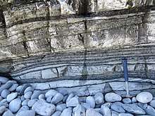
The Random Formation is a rock unit in Newfoundland dating to the early Cambrian period, dominated by tidal quartz arenites deposited in a near-shore environment, but also incorporating intertidal and open-shelf deposits, including glauconitic and mud-cracked mudstones (now shales), and red channel sandstones.[4][7] It was deposited quickly and is approximately 175 m thick.[8] The Blue Pinion Formation was originally recognized as a separate formation, but is now interpreted as an expression of the Random Formation.[9][10]
| Random Formation Stratigraphic range: Early Cambrian | |
|---|---|
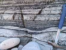
 Some facies of the Random Formation: Synaresis cracks in mudstones, with overlying white cross-bedded tidal sandstones | |
| Type | Formation |
| Unit of | Young's Cove Group,[1] Musgravetown Group,[2] or none,[3] depending on authority (and location) |
| Underlies | (Unconformably) Bonavista Fm and others[4] |
| Overlies |
|
| Thickness | From a few metres to 250 m[6] |
| Lithology | |
| Primary | Herringbone-crossstratified white arenites |
| Other | Grey-green silts and shales |
| Location | |
| Region | |
| Country | |
| Type section | |
| Named for | Random Island |
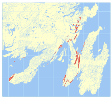
 Bedrock distribution of the Random Formation | |
Sedimentology
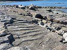
Its white arenitic sandstones are very distinctive, recognizable from their herringbone cross-stratification that denotes the influence of storm systems. Interbedded green-grey sands and silts represent an intertidal setting.[5]
Spatial distribution
It is widespread throughout Newfoundland unlike its underlying units. It was deposited in intertidal mud flats to subtidal setting, then (later) near the bottom of an open marine shelf.[11]
The top of the unit intergrades with the overlying strata.[10]
Stratigraphy

Some studies[1] assign the Random Formation as the lowest unit of the Adeyton Group, but strictly it is below that group.[5]
It overlies the Chapel Island formation, which contains the Precambrian/Cambrian boundary.[12]
The unit is often strongly folded.[5]
Age

The formation is difficult to date, but is considered Precambrian, as it lies unconformably under the Bonavista Formation and conformably above Ediacaran strata.[2] It does sit above the Chapel Island Formation on the Burin peninsula meaning that, at that location, the lower boundary is in the Lower Cambrian. Inarticulate brachiopods have been found in its upper strata, dating these to the late early or even early mid Cambrian.[10]
However, it is likely that the unit is diachronous and may date into the Ediacaran further to the east.[10]
The Cambrian stage 2 - stage 3 boundary (Tommotian/Atdabanian) has been reported as being within the Random Formation, or possibly in the overlying Bonavista Formation. The overlying Smith Point Formation hosts the first trilobites.[13]
Palaeontology
The trilobite-like trace fossils Rusophycus and Cruziana occur in the Random Formation, alongside a range of other ichnofossils including Diplocraterion, Paleodictyon, Scolicia, and Squamodictyon.[13] Body fossils include the small shelly fauna Aldanella attleborensis assemblage.[14]
References
- "BEDROCK GEOLOGY OF THE CAPE ST. MARY'S PENINSULA, SOUTHWEST AVALON PENINSULA, NEWFOUNDLAND" (PDF). Retrieved 8 June 2017. Cite journal requires
|journal=(help) - "LATE NEOPROTEROZOIC (EDIACARAN) STRATIGRAPHY OF AVALON ZONE SEDIMENTARY ROCKS, BONAVISTA PENINSULA, NEWFOUNDLAND" (PDF). Retrieved 8 June 2017. Cite journal requires
|journal=(help) - Normore (2012). "Current Research". Report 12-1. Cite journal requires
|journal=(help) - Smith, S. A.; Hiscott, R. N. (1987). Can. J. Earth Sci. 21: 1379–1392. Missing or empty
|title=(help) - Normore, L. S. (2012). "GEOLOGY OF THE RANDOM ISLAND MAP AREA (Nts 2C/04), Newfoundland". Newfoundland and Labrador Department of Natural Resources Geological Survey Report. 12: 121–145.
- Hiscott, R. N. (1982). "Tidal deposits of the Lower Cambrian Random Formation, eastern Newfoundland; facies and paleoenvironments". Canadian Journal of Earth Sciences. 19: 2028–2042. Bibcode:1982CaJES..19.2028H. doi:10.1139/e82-180.
- Hiscott, Richard N. (1982). "Tidal deposits of the Lower Cambrian Random Formation, eastern Newfoundland: Facies and Paleoenvironments". Canadian Journal of Earth Sciences. 19 (10): 2028. Bibcode:1982CaJES..19.2028H. doi:10.1139/e82-180.
- Crimes, Thomas Peter (1992). "The Record of Trace Fossils across the Proterozoic—Cambrian Boundary". Origin and Early Evolution of the Metazoa. Topics in Geobiology. 10. p. 177. doi:10.1007/978-1-4899-2427-8_6. ISBN 978-1-4899-2429-2.
- Anderson, M. M. (1981). "The Random Formation of southeastern Newfoundland; a discussion aimed at establishing its age and relationship to bounding formations". American Journal of Science. 281 (6): 807. doi:10.2475/ajs.281.6.807.
- Greene, Bryan; Williams, Harold (1974). "New Fossil Localities and the Base of the Cambrian in Southeastern Newfoundland". Canadian Journal of Earth Sciences. 11 (2): 319. doi:10.1139/e74-027.
- Smith, S. A.; Hiscott, R. N. (1987). "Latest precambrian to Early Cambrian basin evolution, Fortune Bay, Newfoundland fault–bounded basin to platform". Canadian Journal of Earth Sciences. 21: 1379–1392. doi:10.1139/e84-143.
- Gehling, James G.; Jensen, Sören; Droser, Mary L.; Myrow, Paul M.; Narbonne, GUY M. (2001). "Burrowing below the basal Cambrian GSSP, Fortune Head, Newfoundland". Geological Magazine. 138 (2). Bibcode:2001GeoM..138..213G. doi:10.1017/S001675680100509X.
- Peter Crimes, T. (1987). "Trace fossils and correlation of late Precambrian and early Cambrian strata". Geological Magazine. 124 (2): 97–119. doi:10.1017/S0016756800015922.
- Bengtson, Stefan; Fletcher, Terence P. (1983). "The oldest sequence of skeletal fossils in the Lower Cambrian of southeastern Newfoundland". Canadian Journal of Earth Sciences. 20 (4): 525. Bibcode:1983CaJES..20..525B. doi:10.1139/e83-050.