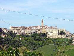
Petritoli
Petritoli is a comune (municipality) in the Province of Fermo in the Italian region Marche, located about 90 kilometres (56 mi) south of Ancona and about 50 kilometres (31 mi) north of Ascoli Piceno.
Petritoli | |
|---|---|
| Comune di Petritoli | |
 | |
 Coat of arms | |
Location of Petritoli 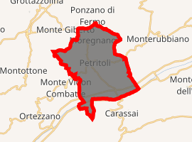
| |
 Petritoli Location of Petritoli in Italy 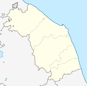 Petritoli Petritoli (Marche) | |
| Coordinates: 43°4′N 13°39′E | |
| Country | Italy |
| Region | Marche |
| Province | Fermo (FM) |
| Frazioni | Moregnano, Valmir |
| Government | |
| • Mayor | Luca Pezzani |
| Area | |
| • Total | 23.8 km2 (9.2 sq mi) |
| Elevation | 358 m (1,175 ft) |
| Population | |
| • Total | 2,494 |
| • Density | 100/km2 (270/sq mi) |
| Demonym(s) | Petritolesi |
| Time zone | UTC+1 (CET) |
| • Summer (DST) | UTC+2 (CEST) |
| Postal code | 63027 |
| Dialing code | 0734 |
| Patron saint | St. John the Baptist |
| Saint day | 24 June |
Petritoli borders the following municipalities: Carassai, Monte Giberto, Monte Vidon Combatte, Montefiore dell'Aso, Monterubbiano, Ponzano di Fermo.
Twin towns

gollark: Some of the time it's actually just an AI designed to occasionally post memes, answer/complain about very simple questions and talk about potatOS.
gollark: Bold of you to assume I actually have a job, let alone one in which I interact with the horrors of Windows.
gollark: Download them in advance, I mean, if I actually needed to use Windows.
gollark: If I particularly wanted to I could just download multiple ISOs and select which one to use when necessary.
gollark: I can just use my phone for that, there are a bunch of apps to allow your (rooted, Android) phone to act as a USB mass storage device.
References
- "Superficie di Comuni Province e Regioni italiane al 9 ottobre 2011". Istat. Retrieved 16 March 2019.
- All demographics and other statistics: Italian statistical institute Istat.
- "Popolazione Residente al 1° Gennaio 2018". Istat. Retrieved 16 March 2019.
This article is issued from Wikipedia. The text is licensed under Creative Commons - Attribution - Sharealike. Additional terms may apply for the media files.