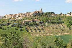
Monte Giberto
Monte Giberto is a comune (municipality) in the Province of Fermo in the Italian region Marche, located about 60 kilometres (37 mi) south of Ancona and about 30 kilometres (19 mi) north of Ascoli Piceno. As of 31 December 2004, it had a population of 865 and an area of 12.7 square kilometres (4.9 sq mi).[3]
Monte Giberto | |
|---|---|
| Comune di Monte Giberto | |
 | |
Location of Monte Giberto 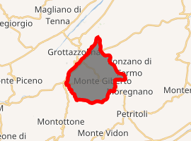
| |
 Monte Giberto Location of Monte Giberto in Italy 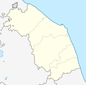 Monte Giberto Monte Giberto (Marche) | |
| Coordinates: 43°6′N 13°38′E | |
| Country | Italy |
| Region | Marche |
| Province | Province of Fermo |
| Area | |
| • Total | 12.7 km2 (4.9 sq mi) |
| Elevation | 323 m (1,060 ft) |
| Population (Dec. 2004)[2] | |
| • Total | 865 |
| • Density | 68/km2 (180/sq mi) |
| Demonym(s) | Montegibertesi |
| Time zone | UTC+1 (CET) |
| • Summer (DST) | UTC+2 (CEST) |
| Postal code | 63020 |
| Dialing code | 0734 |
| Website | Official website |
Monte Giberto borders the following municipalities: Grottazzolina, Monte Vidon Combatte, Montottone, Petritoli, Ponzano di Fermo.
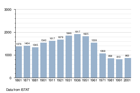
Demographic evolution
gollark: Interesting! Maybe I should do bees with this at some point.
gollark: If only SOMEONE had FIXED ESOBOT so I could participate and it would alert me to these things.
gollark: After I went to all that effort to generate MD5 collisions to appear more betterer at guessing, I really should have made sure to not fill in things twice.
gollark: I should pay more attention to this. This is not part of a gollarious conspiracy.
gollark: I did? Oops.
References
- "Superficie di Comuni Province e Regioni italiane al 9 ottobre 2011". Istat. Retrieved 16 March 2019.
- "Popolazione Residente al 1° Gennaio 2018". Istat. Retrieved 16 March 2019.
- All demographics and other statistics: Italian statistical institute Istat.
This article is issued from Wikipedia. The text is licensed under Creative Commons - Attribution - Sharealike. Additional terms may apply for the media files.