Patillas, Puerto Rico
Patillas (Spanish pronunciation: [paˈtiʎas]) is a municipality of Puerto Rico located in the southeastern coast, south of San Lorenzo; west of Yabucoa and Maunabo; and east of Guayama and Arroyo. It is spread over 15 wards and Patillas Pueblo (the downtown area and the administrative center of the city). It is part of the Guayama Metropolitan Statistical Area.
Patillas Municipio de Patillas | |
|---|---|
Town and Municipality | |
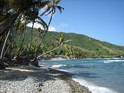
 Beach in Patillas | |
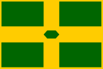
 Flag | |
| Nicknames: "La Esmeralda del Sur", "Los Leones" | |
| Anthem: "Patillenses" | |
 Location in the commonwealth of Puerto Rico | |
| Coordinates: 18°00′23″N 66°00′57″W | |
| Commonwealth | |
| Founded | 1760 |
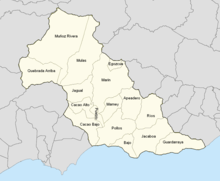
| Wards | |
| Government | |
| • Mayor | Norberto Soto Figueroa (PPD) |
| • Senatorial dist. | 7 - Humacao |
| • Representative dist. | 34 |
| Area | |
| • Total | 59.3 sq mi (153.62 km2) |
| • Land | 48.3 sq mi (125 km2) |
| • Water | 11.1 sq mi (28.62 km2) |
| Population (2010) | |
| • Total | 19,277 |
| • Density | 330/sq mi (130/km2) |
| Demonym(s) | Patillenses |
| Time zone | UTC−4 (AST) |
| ZIP Code | 00723 |
| Area code(s) | 787/939 |
| Major routes | |
History
As early as 1760 there were people already settled in Patillas. It was not, however, a permanent settlement until it was officially founded in 1811. In 1841 a fire in Patillas killed a great many people.[1]
Patillas is located along the southeastern coast of the island of Puerto Rico. There was an establishment of a sugar cane mill which took advantage of the agricultural potential the valley provided. As this establishment provided a good source of income for the neighbors it also was the main reason for the town's foundation in 1811. Doña Adelina Cintrón, owner of "La Finca Patillas", donated almost 8 acres (32,000 m2) of land for the foundation. Most of the neighbors then relocated towards the west side of the proposed site called Cacao Bajo.
Hurricane Maria
Hurricane Maria on September 20, 2017 triggered numerous landslides in Patillas with the significant amount of rainfall.[2][3]
Geography
Patillas is located on the southeastern coast. Despite being located in the region known as the Coast Valley of the South, a part of the town is mountainous. The Sierra de Cayey borders the town's territory through the northern region, and the Sierra de Guardarraya through the east.[4]
Map References
Coordinates: 18.0064° N, 66.0158° W Zip Code: 00723 Driving Distance from San Juan: 59.6 miles Driving Time: 1 hour, 31 minutes
Transportation
Puerto Rico Highway 53 and Road #3 provide access to Patillas from the nearby city of Ponce. Patillas lies at about 1.25 hours from San Juan.
There is an airport, Patillas Airport, but it does not have any commercial air service. The nearest commercial airport with international air service (to the United States mainland) is Mercedita Airport in Ponce. The nearest commercial airport with major commercial air service is Luis Muñoz Marín International Airport in Carolina.
There are 32 bridges in Patillas.[5]
Barrios

Like all municipalities of Puerto Rico, Patillas is subdivided into barrios. The municipal buildings, central square and large Catholic church are located in a barrio referred to as "el pueblo".[6][7][8]
Sectors
Barrios (which are like minor civil divisions)[9] in turn are further subdivided into smaller local populated place areas/units called sectores (sectors in English). The types of sectores may vary, from normally sector to urbanización to reparto to barriada to residencial, among others.[10][11][12]
Special Communities
Of the 742 places on the list of Comunidades Especiales de Puerto Rico, the following barrios, communities, sectors, or neighborhoods were in Patillas: Sector Barro Blanco in Bajos, Sector Higüero in Jacaboa, Sector Recio in Guardarraya, and Quebrada Arriba.[13]
Tourism
Landmarks and places of interest
There are 28 beaches in Patillas.[14][15]
Some places of interest in Patillas include:[16]
- Charco Azul (river)
- Los Tres Chorros (river)
- Carite-Guavate Forest
- Escondida Beach
- Guardarraya Beach
- Charco de la Vuelta
- Villa Pesquera Beach
- Lago de Patillas
- Guavate Forest and places to eat
Festivals and events
Patillas celebrates its patron saint festival in August. The Fiestas Patronales de San Benito Abad is a religious and cultural celebration that generally features parades, games, artisans, amusement rides, regional food, and live entertainment.[4][17]
Other festivals and events celebrated in Patillas include:
- Emerald of the South Carnival – May
- Southeast Marathon – November
- Wheat Flour Festival – December
- Christmas Parade – December
Bodies of water

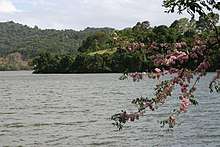
Río de Apeadero, Río Chico, Río Grande de Patillas, Río Jacaboa, and Río Marín (rivers) and a number of creeks flow through Patillas. There is also the Patillas Reservoir called Lago Patillas which was built in 1914. The Patillas and Marín Rivers flow into the reservoir which is also used for fishing.
Economy
Demographics
| Historical population | |||
|---|---|---|---|
| Census | Pop. | %± | |
| 1900 | 11,163 | — | |
| 1910 | 14,448 | 29.4% | |
| 1920 | 14,284 | −1.1% | |
| 1930 | 14,178 | −0.7% | |
| 1940 | 17,319 | 22.2% | |
| 1950 | 18,851 | 8.8% | |
| 1960 | 17,106 | −9.3% | |
| 1970 | 17,828 | 4.2% | |
| 1980 | 17,774 | −0.3% | |
| 1990 | 19,633 | 10.5% | |
| 2000 | 20,152 | 2.6% | |
| 2010 | 19,277 | −4.3% | |
| U.S. Decennial Census[18] 1899 (shown as 1900)[19] 1910-1930[20] 1930-1950[21] 1960-2000[22] 2010[23] | |||
The United States took control of Puerto Rico from Spain in the aftermath of the Spanish-American War under the terms of the Treaty of Paris of 1898 and conducted its first census of Puerto Rico, finding that the population of Patillas was 11,163.
According to the 2000 census, Patillas has a population of 20,152 with a population density is 426.0 people per square mile (163.9/km2). Although there was a decline in the population during the 1960s and the 1990s, it has steadily increased during the last decade.
Puerto Rico is primarily made up of a mix of ancestors from Indigenous, European or African descent. Statistics from the 2000 census shows that 67.7% of Patillenses self-identify as Spanish as in European or white origin which could include White-American since the United States has had a strong presence on the island since 1899; only 12.3% self-identify as Afro Puerto Rican and 0.5% self-identify as Amerindian.
| Race - Patillas, Puerto Rico - 2000 Census[24] | ||
|---|---|---|
| Race | Population | % of Total |
| White | 13,633 | 67.7% |
| Black/African American | 2,482 | 12.3% |
| American Indian and Alaska Native | 95 | 0.5% |
| Asian | 23 | 0.1% |
| Native Hawaiian/Pacific Islander | 7 | 0.0% |
| Some other race | 1,452 | 7.2% |
| Two or more races | 2,460 | 12.2% |
Government
Like all municipalities in Puerto Rico, Patillas is administered by a mayor. The current mayor is Norberto Soto Figueroa, from the Popular Democratic Party (PPD). Soto was elected at the 2012 general election.
The city belongs to the Puerto Rico Senatorial district VII, which is represented by two Senators. In 2012, Jorge Suárez and José Luis Dalmau were elected as District Senators.[25]
Education
Patillas has several public and private schools distributed through several regions. Public education is handled by the Puerto Rico Department of Education.
Symbols
Flag
The flag of Patillas has four green rectangles on the corners that symbolize the valleys and mountains of the town. These rectangles are separated by a golden cross symbolizing the fidelity towards the town's religious patron "El Santo Cristo de la Salud". Superimposed in the middle of the golden cross is an emerald, thus the nickname "La Esmeralda del Sur".
The art design of the flag was a creation of Pedro de Pedro in 1977. Each symbol on the flag was defined by Pedro J. Rivera Arbolay. The legal assessor was the attorney Roberto Beascochea Lota.
Coat of arms
The coat of arms features a crow with a piece of bread in its beak, which represents the bird that saved the life to San Benito Abad, patron of the town, from being poisoned with a piece of bread. The castle with three windows symbolizes the captivity of Santa Barbara, matron of Patillas in the first years of the foundation and the devotion to the Holy Trinity. The cross represents Santo Cristo de la Salud. The two crossed machetes underneath the cross represent the peasants' struggle in the sugar cane plantations and the origins of economic development. The three towers in the superior part mean that Patillas is categorized as a town. The watermelon leaf, fruit that abounded in the west of Patillas, is the reason for the name of the town. The motto "Ora et Labora", means "Pray and Work"; motto of the religious order of San Benito Abad.
Names
The name Patillas is originally an indigenous name for a native type of watermelon. The large abundance of this fruit in the area, along with the land donation from the original owner, lead to the town's name.
The Emerald of the South
Although it is both a mountain town and a beach town, Patillas is known as the "Emerald of the South" for its majestic green color that stands out from the mountains with the reflection of the sun. This town has natural resources that invite the disconnection of the bustle of the city, such as beaches, forests, and the Patillas Lake. The coastal waters and the lake are used by many for recreational fishing.
Anthem: "Patillenses"
By Andrés Plaud Soto
Patillenses, ¡Veis la luz, de la antorcha y su esplendor, que ilumina en noble gesta de amor... la ruta que recorrió, el que por ti ayer luchó, en las lides de los campos del honor!
No olvidéis otras proezas en las Artes del Saber, producto de otros hermanos, que este pueblo vio nacer. Sus conquistas celebramos con solemne admiración: ¡Hosana mis compueblanos... Les brindo mi corazón!
Distinguished Citizens, best known as "Patillenses"
Sigfredo Badillo-Rivero – poet and reciter
David "Quique" Bernier - Dentist, accomplished athlete and politician who served in various roles in public service in Puerto Rico. Bernier first served as executive director of the Office of Youth Affairs of Puerto Rico and was later confirmed as the youngest Secretary of Sports and Recreation of Puerto Rico in history. Four years later, he was unanimously confirmed as Secretary of State of Puerto Rico for the administration of Alejandro García Padilla. He was the 2016 candidate for Governor of Puerto Rico of the Popular Democratic Party. As a member of the National Fencing Selection of Puerto Rico, Bernier was the Panamerican Youth Champion for three consecutive years. He also won the bronze medal in the 1998 Central American and Caribbean Games, celebrated in Maracaibo, Venezuela.
Francisco Cervoni-Gely – poet, playwright, journalist, and political figure. He was a delegate to the House for Guayama (1911 – 1912). His plays include Los suegros (1897) and La cruz roja (1928). His poetry was published in newspapers and magazines.
Gaspar Cochran – Recreational leader of Patillas in 1952 and the first to register a baseball team class "A" called the Lions of Patillas. For 20 years he was director of the annual Patron Saint Festivals.
José Dávila Ricci – political figure and journalist. Dávila was a member of the governing board of the Liberal Party (1932 – 1940). He also founded and presided the Puerto Rico Journalism Association (1938). He collaborated with newspapers such as El Mundo and El Universal, and headed La Democracia (1928 – 1932), Puerto Rico Ilustrado (1937 – 1938) and El Imparcial.
Edmundo Disdier – musician and composer. His compositions include Amor soñado, Lo imposible and Reflejo.
Olga D. González-Sanabria - Scientist and inventor. She is the highest ranking Hispanic at NASA Glenn Research Center, and a member of the Ohio Women's Hall of Fame. González-Sanabria, Director of the Engineering and Technical Services, is responsible for planning and directing a full range of integrated services including engineering, fabrication, testing, facility management and aircraft services for the Glenn Research Center. She played an instrumental role in the development of the "Long Cycle-Life Nickel-Hydrogen Batteries" which helps enable the International Space Station power system. González-Sanabria's governmental service is 30 years with NASA, where she still works today.
Luisa Lebrón Burgos - Judge, politician, and former member of the Senate of Puerto Rico from 1993 to 2000. She currently serves as a judge in the Carolina region.
Ramón Lebrón-Rodríguez – writer. His works include Esbozo histórico del Derecho Penal (1916) and La vida de un prócer (1954), among others.
Angelita Lind – Outstanding athlete. Named the Angel of Puerto Rico by the people of the Island. Winner of three gold medals, 3 silver medals and 1 bronze medal, she participated in 3 Central American and Caribbean Games, 3 Pan American Games and the Olympics in Los Angeles, California.
Alondra Maldonado-Rosario - Outstanding athlete. Member of the Women's Sub-18 National Volleyball Team, an outside opposite and middle blocker, who participated in the 2019 World Cup in Egypt.
Emilio "Millito" Navarro (born September 26, 1905 in the city of Patillas, Puerto Rico) - First Puerto Rican to play baseball in the Negro Leagues.
Andrés Plaud-Soto – teacher, and author of Patillas' anthem.
Paulino Rodríguez – His literary work includes: Gotas de Estío (children's reading), The Son of Regret (novel), My Lonely Garden (poetry), and the History of the Town of Patillas.
Luis Manuel Santana-Gastón – lawyer and professor. Patillas Cultural Center is named after him.
Jalil Sued-Badillo – historian and teacher.
Cirilo Tirado-Rivera - Politician and member of the Senate of Puerto Rico since 2000.
See also
- List of Puerto Ricans
- History of Puerto Rico
- Did you know-Puerto Rico?
References
- Manuel Ubeda y Delgado (1878). Isla de Puerto Rico: estudio histórico, geográfico y estadístico de la misma (in Spanish). Academia Puertorriqueńa de la Historia. pp. 271–.
- "Preliminary Locations of Landslide Impacts from Hurricane Maria, Puerto Rico". USGS Landslide Hazards Program. USGS. Archived from the original on 2019-03-03. Retrieved 2019-03-03.
- "Preliminary Locations of Landslide Impacts from Hurricane Maria, Puerto Rico" (PDF). USGS Landslide Hazards Program. USGS. Archived (PDF) from the original on 2019-03-03. Retrieved 2019-03-03.
- "Patillas Municipality". enciclopediapr.org. Fundación Puertorriqueña de las Humanidades (FPH).
- "Patillas Bridges". National Bridge Inventory Data. US Dept. of Transportation. Archived from the original on 20 February 2019. Retrieved 19 February 2019.
- Picó, Rafael; Buitrago de Santiago, Zayda; Berrios, Hector H. Nueva geografía de Puerto Rico: física, económica, y social, por Rafael Picó. Con la colaboración de Zayda Buitrago de Santiago y Héctor H. Berrios. San Juan Editorial Universitaria, Universidad de Puerto Rico,1969. Archived from the original on 2018-12-26. Retrieved 2018-12-31.
- Gwillim Law (20 May 2015). Administrative Subdivisions of Countries: A Comprehensive World Reference, 1900 through 1998. McFarland. p. 300. ISBN 978-1-4766-0447-3. Retrieved 25 December 2018.
- "Map of Patillas at the Wayback Machine" (PDF). Archived from the original (PDF) on 2018-03-24. Retrieved 2018-12-29.
- "US Census Barrio-Pueblo definition". factfinder.com. US Census. Archived from the original on 13 May 2017. Retrieved 5 January 2019.
- "Agencia: Oficina del Coordinador General para el Financiamiento Socioeconómico y la Autogestión (Proposed 2016 Budget)". Puerto Rico Budgets (in Spanish). Archived from the original on 28 June 2019. Retrieved 28 June 2019.
- Rivera Quintero, Marcia (2014), El vuelo de la esperanza: Proyecto de las Comunidades Especiales Puerto Rico, 1997-2004 (first ed.), San Juan, Puerto Rico Fundación Sila M. Calderón, ISBN 978-0-9820806-1-0
- "Leyes del 2001". Lex Juris Puerto Rico (in Spanish). Archived from the original on 14 September 2018. Retrieved 24 June 2020.
- Rivera Quintero, Marcia (2014), El vuelo de la esperanza:Proyecto de las Comunidades Especiales Puerto Rico, 1997-2004 (Primera edición ed.), San Juan, Puerto Rico Fundación Sila M. Calderón, p. 273, ISBN 978-0-9820806-1-0
- "Las 1,200 playas de Puerto Rico [The 1200 beaches of Puerto Rico]". Primera Hora (in Spanish). April 14, 2017. Archived from the original on December 12, 2019. Retrieved December 12, 2019.
- "Beach Monitoring and Public Notification Program" (PDF). drna.pr.gov. Puerto Rico Department of Natural and Environmental Resources. 6 March 2020. Retrieved 25 June 2020.
- "Patillas". Discover Puerto Rico. Archived from the original on 2019-11-04. Retrieved 2019-11-04.
- "Puerto Rico Festivales, Eventos y Actividades en Puerto Rico". Puerto Rico Hoteles y Paradores (in Spanish). Archived from the original on 2020-02-26. Retrieved 2020-07-17.
- "U.S. Decennial Census". United States Census Bureau. Archived from the original on February 13, 2020. Retrieved September 21, 2017.
- "Report of the Census of Porto Rico 1899". War Department, Office Director Census of Porto Rico. Archived from the original on July 16, 2017. Retrieved September 21, 2017.
- "Table 3-Population of Municipalities: 1930, 1920, and 1910" (PDF). United States Census Bureau. Archived (PDF) from the original on August 17, 2017. Retrieved September 21, 2017.
- "Table 4-Area and Population of Municipalities, Urban and Rural: 1930 to 1950" (PDF). United States Census Bureau. Archived (PDF) from the original on August 30, 2015. Retrieved September 21, 2014.
- "Table 2 Population and Housing Units: 1960 to 2000" (PDF). United States Census Bureau. Archived (PDF) from the original on July 24, 2017. Retrieved September 21, 2017.
- Puerto Rico:2010:population and housing unit counts.pdf (PDF). U.S. Dept. of Commerce, Economics and Statistics Administration, U.S. Census Bureau. 2010. Archived (PDF) from the original on 2017-02-20. Retrieved 2018-12-26.
- "Ethnicity 2000 census" (PDF). Archived (PDF) from the original on 2008-02-16. Retrieved 2009-04-06.
- Elecciones Generales 2012: Escrutinio General Archived January 23, 2013, at the Wayback Machine on CEEPUR