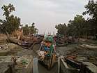
Patharghata Upazila
Patharghata (Bengali: পাথরঘাটা উপজেলা) is an Upazila of Barguna District[1] in the Division of Barisal, Bangladesh.
| ||||||||||||||||||||||||||||||||||||||||||||||||||||||||||||||||||||||||||||||||||||||||||||||||||||||||||||||||||||||||||||
Patharghata Upazila পাথরঘাটা উপজেলা | |
|---|---|
Upazila | |
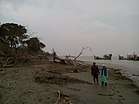    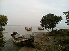 Skyline of Patharghata, Bangladesh | |
 Patharghata Upazila Location in Bangladesh | |
| Coordinates: 22°2.7′N 89°58.1′E | |
| Country | |
| Division | Barisal Division |
| District | Barguna District |
| Area | |
| • Total | 387.36 km2 (149.56 sq mi) |
| Population (1991) | |
| • Total | 134,635 |
| • Density | 350/km2 (900/sq mi) |
| Time zone | UTC+6 (BST) |
| Website | Official Map of the Patharghata Upazila |
Geography
Patharghata is located at 22.0458°N 89.9689°E. It has 25,610 households and a total area of 387.36 km².
Demographics
As of the 1991 Bangladesh census, Patharghata has a population of 134635. Males constitute 50.56% of the population, and females 49.44%. This Upazila's eighteen up population is 68751. Patharghata has an average literacy rate of 66.4% (7+ years), and the national average of 32.4% literate.[4]
Administration
Patharghata has 7 unions/wards, 43 Mauzas/Mahallas, and 67 villages. It is near Bay Of Bengal.
gollark: Oh no, edgyish question warning.
gollark: https://osmarks.net/
gollark: ↑ torus
gollark: https://upload.wikimedia.org/wikipedia/commons/6/67/Standard_torus-spindle.png
gollark: ↑ geometry
See also
- Upazilas of Bangladesh
- Districts of Bangladesh
- Divisions of Bangladesh
References
- Safiuddin Ahmed (2012). "Patharghata Upazila". In Sirajul Islam and Ahmed A. Jamal (ed.). Banglapedia: National Encyclopedia of Bangladesh (Second ed.). Asiatic Society of Bangladesh.
- "NASA Earth Observations: Rainfall (1 month - TRMM)". NASA/Tropical Rainfall Monitoring Mission. Retrieved 30 January 2016.
- "NASA Earth Observations Data Set Index". NASA. Retrieved 30 January 2016.
- "Population Census Wing, BBS". Archived from the original on 2005-03-27. Retrieved November 10, 2006.
| Upazila/Thana: | ||
|---|---|---|
Capital: Barisal | ||
| Barguna District | 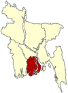 | |
| Barisal District | ||
| Bhola District |
| |
| Jhalokati District | ||
| Patuakhali District | ||
| Pirojpur District | ||
This article is issued from Wikipedia. The text is licensed under Creative Commons - Attribution - Sharealike. Additional terms may apply for the media files.