Pirojpur District
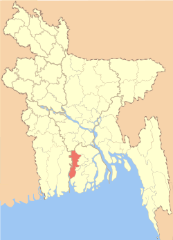
Pirojpur (Bengali: পিরোজপুর) is a district (zilla) in southern-western Bangladesh. It is a part of Barisal Division.[2]
Pirojpur পিরোজপুর | |
|---|---|
 Location of Pirojpur in Bangladesh | |

Expandable map of Pirojpur District | |
| Coordinates: 22.58°N 89.97°E | |
| Country | |
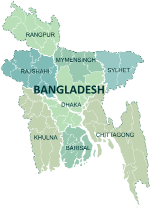
| Division | Barisal Division |
| Area | |
| • Total | 1,277.80 km2 (493.36 sq mi) |
| Population (2011 census) | |
| • Total | 1,131,758 |
| • Density | 890/km2 (2,300/sq mi) |
| Demonym(s) | Pirojpuri, Firozpuri |
| Time zone | UTC+06:00 (BST) |
| Postal code | 8500 |
| HDI (2018) | 0.672[1] medium · 2nd of 21 |
Name
According to myth, the second son of Subedar Shah Shuja, Firoz Shah, died in this area, and the area became known subsequently as 'Firozpur'. In time, the pronunciation 'Firozpur' slowly muted to 'Pirozpur' and later 'Pirojpur'.[3]
Demographics
Pirojpur District had a population of 1,131,758 according to 2011 Census of Population.
Geography
Most of the land is low-lying and the soil is fertile. There are small forests.
Nesarabad is known for its business centre and also for the Sundori tree (a kind of mangrove) that grows there.
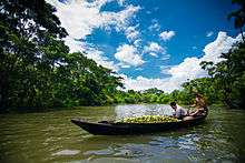
Launches, steamers and boats are used for travelling on the rivers. The local port is called Hoolarhaat Launch Station (ghaat). Buses, autorickshaws and rickshaws are also used for transport. Old Bus Station(Puraton Bus Station) is one of the most popular place of this district.
Borders
Pirojpur District is bordered by Barisal and Gopalganj districts to the north, Barguna district to the south, Jhalokati and Barguna districts to the east, Bagerhat district and The Sundarbans, the largest mangrove forest to the west.
Administration
The subdivision (then a mohokooma, now a zilla) of Pirojpur was created in 28 October 1859 Pirojpur district was formed in 1 March in 1984 and the municipality was formed in 1885. The area of Pirojpur is 1277.80 km2. It is under Barisal Division. There are three municipalities in Pirojpur named Pirojpur, Bhandaria, Mathbaria. There are seven upazilas (sub districts) in Pirojpur district: Pirojpur Sadar, Bhandaria, Mathbaria, Indurkani, Nazirpur, Nesarabad and Kawkhali. Of these, Mathbaria is the largest (353.25 km2; it occupies 27.01% of the total area of the district). Kawkhali is the smallest (79.65 km2). Pirojpur District also contains 52 unions, 390 mauzas and 648 villages.[4]
Sub Districts (Upazillas)
There are seven Sub Districts in Pirojpur and their population are given below:[7]
| Upazillas | Population |
|---|---|
| Bhandaria | 164,618 |
| Kawkhali | 70,515 |
| Mathbaria | 262,841 |
| Nazirpur | 180,408 |
| Nesarabad | 212,232 |
| Pirojpur Sadar | 163,470 |
| Indurkani | 77,674 |
Rivers
Gabkhan, Baleshwar, Damodar, Kocha, Pona, Kochakhali, Kaliganga, Sandha, Doratana etc. are big and known rivers.
The Baleshwar, the river that is situated to the east of Sunder Bans splits into two parts, but this is getting smaller and smaller day by day. One is known as Doratana which flows through Bagerhat and the other and mightier one is known as Kacha which flows through Bhandaria. Then it has an offshoot Baleshwar which later meets with Doratana and falls into Kaliganga near Mativanga, Najirpur. And Kocha splits into two river Kaliganga and Sandha. Kaliganga flows to the north meets with Baleshwar and flow to further north. and Sandha flows to the east. Later Sandha coalesce with Arial Khan and falls into the Meghna.
Transportation
Buses
There are two bus terminals in Pirojpur, Pirojpur Bus terminal and Pirojpur Old Bus Terminal. Many Bus company connect Pirojpur to other districts like Dhaka and many more.
River port
Hularhat is the river port of Pirojpur. It is situated some 5 km east to the Pirojpur town and the river port stands on Kaliganga. Beside it is the steamer wharf. Launches destined to Dhaka and other parts of the country regularly start from here.
Main sources of income
Agriculture, being the main source of income for rural people here, there are also other sources of income which are mainly city based. They are given below :
•Agriculture 50.82%
•Commerce 18.71%
•Service 7.69%
•Non-Agricultural Labour 5.75%
•Transport and Communication 2.16%,
•Religious Service 1.61%
•Construction 1.36%
•Rent and Remittance 0.95%
•Industry 0.78%
•Others 10.17%
Religion
Muslims, Hindus, a few Christians and a very few Buddhists live here peacefully.
For different religions, there are 3,087 mosques, 1,051 temples.[8]
Agricultural products
Paddy, Jute, Sugar Cane, Wheat, Guava, Banana, Coconut, Hog-plum, Betel Leaf, Betel Nuts are the chief Agricultural Products produced here.[9]
Tourist attractions
- Tasmima Villa, Bhandaria
- Bhandaria Thana Eko Park, Bhandaria
- Aman Ullah Collage, (Baridara Complex), Khatalia Road, Bhandaria.
- Minister Bari Mosque, Bhandaria.
- Kuriana Floating Market
- Kuriana Guava Garden
- Momin Mosque
- Chanmari Shooting Spot
- Pirojpur River View Eco Park (locally known as DC Park)
- Rayerkathi Raaj Bari
- Horinpala River View Eco Park, Telikhali Union, Mathbaria
Media
Print media:
- Prothom Alo (national)
- Kaler Kantho (national)
- Samakal (national)
- Dainik Janakantha (national)
- Jugantor (national)
- Pirojpurer Kotha (local)
Sports and Games
Cricket and Football are the two most popular sports in Pirojpur. However, Kabaddi is also popular.
Among Indoor games, Carrom, Ludo and Chess are played by a lot of people.
Notable people
- Ahsan Habib
- Anwar Hossain Manju
- Delwar Hossain Sayeedi
- Jewel Aich
- Jannatul Ferdous Oishee
- Khalid Hassan Milu
- Tofazzal Hossain Manik Miah
- SM Rezaul Karim
- Km Arif
See also
- Pirojpur
- Districts of Barisal Division
- Districts of Bangladesh
References
| Wikimedia Commons has media related to Pirojpur District. |
- "Sub-national HDI - Area Database - Global Data Lab". hdi.globaldatalab.org. Retrieved 18 March 2020.
- Nupu, Ranjan Baksi (2012). "Pirojpur District". In Islam, Sirajul; Jamal, Ahmed A. (eds.). Banglapedia: National Encyclopedia of Bangladesh (Second ed.). Asiatic Society of Bangladesh.
- "The Daily Ittefaq" (in Bengali).
- "Pirojpur District at a glimpse". 28 August 2019.
- "Zilla Porishod Chairman Information". Pirojpur Zilla. 10 August 2019.
- "Deputy Commissioner Profile". Pirojpur Zilla. 10 August 2019.
- 2011 Census of Population
- "Pirojpur District at a glimpse". 28 August 2019.
- "Natural Assets in Pirojpur". 28 August 2019.
| Upazila/Thana: | ||
|---|---|---|