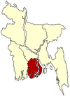
Dumki Upazila
Dumki (Bengali: দুমকি) is an Upazila of Patuakhali District in the Division of Barisal, Bangladesh.[1]
Dumki Upazila দুমকি | |
|---|---|
Upazila | |
 Dumki Upazila Location in Bangladesh | |
| Coordinates: 22°26′N 90°22′E | |
| Country | |
| Division | Barisal Division |
| District | Patuakhali District |
| Area | |
| • Total | 92.46 km2 (35.70 sq mi) |
| Population | |
| • Total | 70,705 |
| • Density | 760/km2 (2,000/sq mi) |
| Time zone | UTC+6 (BST) |
Administration
Patuakhali Sadar has 5 Unions/Wards, 21 Mauzas/Mahallas, and 24 villages. The unions are:[1]
- Angaria
- Lebukhali
- Muradia
- Pangashia
- Sree rampur
gollark: I am the shareholders, of course.
gollark: Idea: put me in charge of dynmap management.
gollark: I probably could if I were to gather data, which I have not done.
gollark: It's probably using virtual filesystem tricks like potatOS.
gollark: Oh no. This could have substantial effects on my IndexedDB-based website achievement system.
See also
- Upazilas of Bangladesh
- Districts of Bangladesh
- Divisions of Bangladesh
References
- Tanvir Ahsan Tariq (2012). "Dumki Upazila". In Sirajul Islam and Ahmed A. Jamal (ed.). Banglapedia: National Encyclopedia of Bangladesh (Second ed.). Asiatic Society of Bangladesh.
This article is issued from Wikipedia. The text is licensed under Creative Commons - Attribution - Sharealike. Additional terms may apply for the media files.
