National Register of Historic Places listings in Quay County, New Mexico
This is a list of the National Register of Historic Places listings in Quay County, New Mexico.
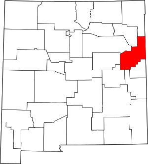
Location of Quay County in New Mexico
This is intended to be a complete list of the properties and districts on the National Register of Historic Places in Quay County, New Mexico, United States. Latitude and longitude coordinates are provided for many National Register properties and districts; these locations may be seen together in a map.[1]
There are 12 properties and districts listed on the National Register in the county. Another property was once listed but has been removed. All of the places within the county on the National Register are also listed on the State Register of Cultural Properties with the single exception of the Arch Hurley Conservancy District Office Building.
- This National Park Service list is complete through NPS recent listings posted August 14, 2020.[2]
| Bernalillo – Catron – Chaves – Cibola – Colfax – Curry – De Baca – Doña Ana – Eddy – Grant – Guadalupe – Harding – Hidalgo – Lea – Lincoln – Los Alamos – Luna – McKinley – Mora – Otero – Quay – Rio Arriba – Roosevelt – San Juan – San Miguel – Sandoval – Santa Fe – Sierra – Socorro – Taos – Torrance – Union – Valencia |
Current listings
| [3] | Name on the Register[4] | Image | Date listed[5] | Location | City or town | Description |
|---|---|---|---|---|---|---|
| 1 | Blue Swallow Motel | 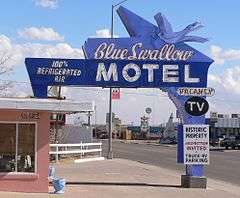 Blue Swallow Motel |
November 22, 1993 (#93001210) |
815 E. Tucumcari Boulevard 35°10′19″N 103°42′58″W |
Tucumcari | |
| 2 | Cactus Motor Lodge | _sign_from_W.JPG) Cactus Motor Lodge |
March 21, 2006 (#06000154) |
1316 E. Tucumcari Boulevard 35°10′16″N 103°42′38″W |
Tucumcari | Now Cactus RV Park.[6] |
| 3 | Glenrio Historic District | 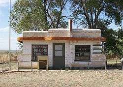 Glenrio Historic District |
January 17, 2007 (#06001258) |
State Road 1578 35°10′43″N 103°02′33″W |
Glenrio | Extends into Deaf Smith County, Texas |
| 4 | Arch Hurley Conservancy District Office Building |  Arch Hurley Conservancy District Office Building |
December 16, 1994 (#94001403) |
101 E. High St. 35°10′34″N 103°43′32″W |
Tucumcari | |
| 5 | Metropolitan Park Bathhouse and Pool Historic District | 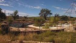 Metropolitan Park Bathhouse and Pool Historic District |
March 15, 1996 (#96000268) |
South frontage road of Interstate 40, 1.5 miles west of the western exit for Tucumcari 35°08′43″N 103°48′01″W |
Tucumcari | |
| 6 | Nara Visa School | 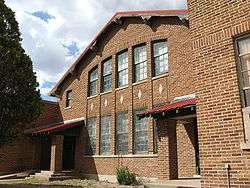 Nara Visa School |
October 31, 1983 (#83004151) |
U.S. Route 54 35°36′51″N 103°05′53″W |
Nara Visa | |
| 7 | Odeon Theater | 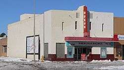 Odeon Theater |
January 17, 2007 (#06001254) |
123 S. 2nd St. 35°10′48″N 103°43′37″W |
Tucumcari | |
| 8 | Richardson Store | Richardson Store |
November 16, 1978 (#78001819) |
Off Interstate 40 35°05′43″N 104°03′55″W |
Montoya | |
| 9 | Route 66, Locally Maintained from Glenrio to San Jon |  Route 66, Locally Maintained from Glenrio to San Jon |
March 24, 1994 (#93001207) |
Texas border west to San Jon 35°08′12″N 103°09′37″W |
San Jon | |
| 10 | Route 66, State maintained from Montoya to Cuervo | 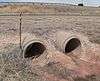 Route 66, State maintained from Montoya to Cuervo |
November 19, 1997 (#97001395) |
Along former U.S. Route 66 from west of Montoya to Cuervo 35°03′41″N 104°16′01″W |
Cuervo | |
| 11 | Route 66, State maintained from Palomas to Montoya | Route 66, State maintained from Palomas to Montoya |
March 24, 1994 (#93001208) |
State frontage road from southeast of Palomas west to Montoya 35°06′43″N 103°58′05″W |
Montoya | |
| 12 | Route 66, State maintained from San Jon to Tucumcari |  Route 66, State maintained from San Jon to Tucumcari |
November 19, 1997 (#97001399) |
Former U.S. Route 66 from east of San Jon to east of the Interstate 40 exit at Tucumcari 35°08′46″N 103°27′09″W |
San Jon |
Former listing
| [3] | Name on the Register | Image | Date listed/removed | Location | City or town | Summary |
|---|---|---|---|---|---|---|
| 1 | Baca-Goodman House | 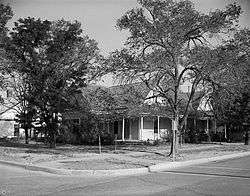 Baca-Goodman House |
Listed 1973, delisted January 1, 1977 (#73002246) |
Aber and 3rd Sts. 35°10′38″N 103°43′40″W |
Tucumcari | Destroyed. |
gollark: It probably should have some sort of "position" counter.
gollark: It couldn't be turn-based AND multiplayer easily.
gollark: Hey, it actually works properly!
gollark: deploy apionodes.
gollark: I don't know. <@332271551481118732> did it.
See also
| Wikimedia Commons has media related to National Register of Historic Places in Quay County, New Mexico. |
References
- The latitude and longitude information provided in this table was derived originally from the National Register Information System, which has been found to be fairly accurate for about 99% of listings. Some locations in this table may have been corrected to current GPS standards.
- "National Register of Historic Places: Weekly List Actions". National Park Service, United States Department of the Interior. Retrieved on August 14, 2020.
- Numbers represent an ordering by significant words. Various colorings, defined here, differentiate National Historic Landmarks and historic districts from other NRHP buildings, structures, sites or objects.
- "National Register Information System". National Register of Historic Places. National Park Service. July 9, 2010.
- The eight-digit number below each date is the number assigned to each location in the National Register Information System database, which can be viewed by clicking the number.
- Cactus RV Park website. Retrieved 2012-02-11.
| Topics | |
|---|---|
| Lists by state |
|
| Lists by insular areas | |
| Lists by associated state | |
| Other areas | |
| Related | |
| |
Municipalities and communities of Quay County, New Mexico, United States | ||
|---|---|---|
| City | Map of New Mexico highlighting Quay County | |
| Villages | ||
| CDP | ||
| Other unincorporated communities | ||
| Footnotes | ‡This populated place also extends into Texas | |
This article is issued from Wikipedia. The text is licensed under Creative Commons - Attribution - Sharealike. Additional terms may apply for the media files.