National Register of Historic Places listings in Curry County, New Mexico
This is a list of the National Register of Historic Places listings in Curry County, New Mexico.
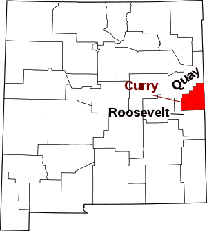
Location of Curry County in New Mexico
This is intended to be a complete list of the properties and districts on the National Register of Historic Places in Curry County, New Mexico, United States. Latitude and longitude coordinates are provided for many National Register properties and districts; these locations may be seen together in a map.[1]
There are 12 properties listed on the National Register in the county. All of the places within the county on the National Register are also listed on the State Register of Cultural Properties.
- This National Park Service list is complete through NPS recent listings posted August 14, 2020.[2]
| Bernalillo – Catron – Chaves – Cibola – Colfax – Curry – De Baca – Doña Ana – Eddy – Grant – Guadalupe – Harding – Hidalgo – Lea – Lincoln – Los Alamos – Luna – McKinley – Mora – Otero – Quay – Rio Arriba – Roosevelt – San Juan – San Miguel – Sandoval – Santa Fe – Sierra – Socorro – Taos – Torrance – Union – Valencia |
Current listings
| [3] | Name on the Register[4] | Image | Date listed[5] | Location | City or town | Description |
|---|---|---|---|---|---|---|
| 1 | 1908 Clovis City Hall and Fire Station | 1908 Clovis City Hall and Fire Station |
July 16, 1987 (#87001110) |
308 Pile St. 34°24′04″N 103°12′02″W |
Clovis | |
| 2 | Clovis Baptist Hospital | Clovis Baptist Hospital |
February 5, 1982 (#82003322) |
515 Prince St. 34°24′12″N 103°11′44″W |
Clovis | |
| 3 | Clovis Central Fire Station | Clovis Central Fire Station |
July 2, 1987 (#87001111) |
320 Mitchell St. 34°24′05″N 103°12′23″W |
Clovis | |
| 4 | Curry County Courthouse | 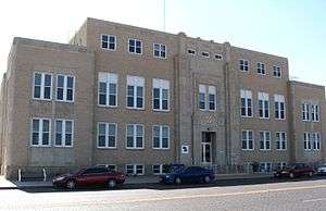 Curry County Courthouse |
June 18, 1987 (#87000881) |
700 block of Main St. 34°24′19″N 103°12′19″W |
Clovis | |
| 5 | First Methodist Church of Clovis |  First Methodist Church of Clovis |
July 2, 1987 (#87001112) |
622 Main St. 34°24′15″N 103°12′19″W |
Clovis | |
| 6 | Hillcrest Park Archway | Hillcrest Park Archway |
July 2, 2008 (#08000573) |
Intersection of East 10th and Sycamore St., approximately 2,757 feet (840 m) east of intersection of 10th and Prince Sts. 34°24′29″N 103°11′15″W |
Clovis | part of the New Deal in New Mexico Multiple Property Submission |
| 7 | Lincoln Jackson School | October 4, 2017 (#100001716) |
206 Alphon St. 34°24′00″N 103°13′31″W |
Clovis | ||
| 8 | Hotel Clovis | 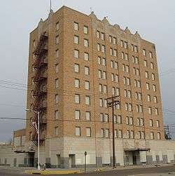 Hotel Clovis |
December 27, 1984 (#84000571) |
210 Main St. 34°24′00″N 103°12′53″W |
Clovis | |
| 9 | Lyceum Theater |  Lyceum Theater |
January 17, 2007 (#06001253) |
409 Main St. 34°24′14″N 103°12′19″W |
Clovis | |
| 10 | Old Clovis Post Office | 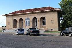 Old Clovis Post Office |
December 27, 1984 (#84000573) |
122 W. 4th St.[6] 34°24′07″N 103°12′23″W |
Clovis | |
| 11 | Santa Fe Passenger Depot-Clovis | Santa Fe Passenger Depot-Clovis |
December 14, 1995 (#95001451) |
221 W. 1st St. 34°23′52″N 103°12′26″W |
Clovis | |
| 12 | State Theater | 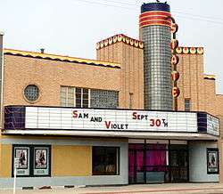 State Theater |
January 17, 2007 (#06001255) |
504 Main St. 34°24′18″N 103°12′20″W |
Clovis |
gollark: There's a test under account settings somewhere.
gollark: Also, an admin called gollark.
gollark: Also, we need a #meta.
gollark: Er, it's a hype squad thing.
gollark: #voice and <#462317162330062869> are mixed up. See?
See also
| Wikimedia Commons has media related to National Register of Historic Places in Curry County, New Mexico. |
References
- The latitude and longitude information provided in this table was derived originally from the National Register Information System, which has been found to be fairly accurate for about 99% of listings. Some locations in this table may have been corrected to current GPS standards.
- "National Register of Historic Places: Weekly List Actions". National Park Service, United States Department of the Interior. Retrieved on August 14, 2020.
- Numbers represent an ordering by significant words. Various colorings, defined here, differentiate National Historic Landmarks and historic districts from other NRHP buildings, structures, sites or objects.
- "National Register Information System". National Register of Historic Places. National Park Service. July 9, 2010.
- The eight-digit number below each date is the number assigned to each location in the National Register Information System database, which can be viewed by clicking the number.
- Address based on signage on front of building when viewed on Google Maps Streetview. Accessed March 28, 2016.
| Topics | |
|---|---|
| Lists by state |
|
| Lists by insular areas | |
| Lists by associated state | |
| Other areas | |
| Related | |
| |
Municipalities and communities of Curry County, New Mexico, United States | ||
|---|---|---|
| Cities | Map of New Mexico highlighting Curry County | |
| Villages | ||
| CDP | ||
| Unincorporated communities | ||
This article is issued from Wikipedia. The text is licensed under Creative Commons - Attribution - Sharealike. Additional terms may apply for the media files.