National Register of Historic Places listings in San Juan County, New Mexico
This is a list of the National Register of Historic Places listings in San Juan County, New Mexico.
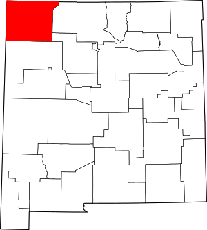
Location of San Juan County in New Mexico
This is intended to be a complete list of the properties and districts on the National Register of Historic Places in San Juan County, New Mexico, United States. Latitude and longitude coordinates are provided for many National Register properties and districts; these locations may be seen together in a map.[1]
There are 38 properties and districts listed on the National Register in the county. All of the listings within the county with the single exception of the Aztec Ruins Administration Building-Museum are also recorded on the State Register of Cultural Properties.
- This National Park Service list is complete through NPS recent listings posted August 14, 2020.[2]
| Bernalillo – Catron – Chaves – Cibola – Colfax – Curry – De Baca – Doña Ana – Eddy – Grant – Guadalupe – Harding – Hidalgo – Lea – Lincoln – Los Alamos – Luna – McKinley – Mora – Otero – Quay – Rio Arriba – Roosevelt – San Juan – San Miguel – Sandoval – Santa Fe – Sierra – Socorro – Taos – Torrance – Union – Valencia |
Current listings
| [3] | Name on the Register[4] | Image | Date listed[5] | Location | City or town | Description |
|---|---|---|---|---|---|---|
| 1 | H.D. Abrams House | February 21, 1985 (#85000322) |
403 N. Church St. 36°49′31″N 107°59′46″W |
Aztec | ||
| 2 | American Hotel |  American Hotel |
February 21, 1985 (#85000323) |
300 S. Main 36°49′07″N 107°59′55″W |
Aztec | |
| 3 | Archeological Site OCA-CGP-56 | February 23, 1978 (#78001822) |
Address Restricted |
Fruitland | ||
| 4 | Austin-McDonald House | February 21, 1985 (#85000324) |
501 Rio Grande 36°49′33″N 107°59′27″W |
Aztec | ||
| 5 | Aztec Main Street Historic District | 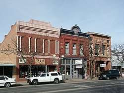 Aztec Main Street Historic District |
February 21, 1985 (#85000321) |
Bounded by Main E., Chuska S., and alley between Park and Main W., and Chaco N. 36°49′19″N 107°59′54″W |
Aztec | |
| 6 | Aztec Motor Company Building | 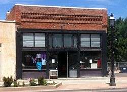 Aztec Motor Company Building |
February 21, 1985 (#85000325) |
301 S. Main 36°49′08″N 107°59′57″W |
Aztec | |
| 7 | Aztec Ruins Administration Building-Museum |  Aztec Ruins Administration Building-Museum |
October 11, 1996 (#96001041) |
Approximately 0.75 miles north of U.S. Route 550, on the outskirts of Aztec in the Aztec Ruins National Monument 36°50′04″N 107°59′58″W |
Aztec | Archeologist Earl Morris lived and worked here; now a visitors center. |
| 8 | Aztec Ruins National Monument | 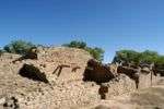 Aztec Ruins National Monument |
October 15, 1966 (#66000484) |
1 mile north of Aztec 36°50′09″N 107°59′51″W |
Aztec | |
| 9 | D.C. Ball House | 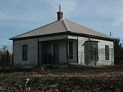 D.C. Ball House |
February 21, 1985 (#85000326) |
300 San Juan 36°49′26″N 107°59′18″W |
Aztec | |
| 10 | Building at 202 Park Avenue | February 21, 1985 (#85000328) |
202 Park Ave. 36°49′17″N 107°59′58″W |
Aztec | ||
| 11 | Building at 500 White Avenue | February 21, 1985 (#85000327) |
500 White Ave. 36°49′34″N 107°59′31″W |
Aztec | ||
| 12 | Christmas Tree Ruin (LA 11097) | January 21, 1987 (#86003646) |
Address Restricted |
Farmington | ||
| 13 | Church Avenue-Lovers Lane Historic District | 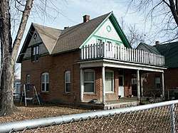 Church Avenue-Lovers Lane Historic District |
February 21, 1985 (#85000329) |
Bounded by Rio Grande E., Zia S., Park W., and State Road 550 36°49′22″N 107°59′41″W |
Aztec | |
| 14 | Cottonwood Divide Site (LA 55829) | January 21, 1987 (#86003644) |
Address Restricted |
Farmington | ||
| 15 | Crow Canyon Archaeological District | 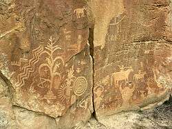 Crow Canyon Archaeological District |
July 15, 1974 (#74001200) |
Address Restricted |
Farmington | Extends into Rio Arriba County |
| 16 | Daws-Keys House | February 21, 1985 (#85000330) |
421 N. Church 36°49′32″N 107°59′44″W |
Aztec | ||
| 17 | Denver and Rio Grande Western Railway Depot |  Denver and Rio Grande Western Railway Depot |
February 21, 1985 (#85000331) |
314 Rio Grande 36°49′26″N 107°59′22″W |
Aztec | |
| 18 | East Side Rincon Site | December 15, 1985 (#85003154) |
3 miles north of Farmington[6] 36°43′41″N 108°13′07″W |
Farmington | ||
| 19 | Engleman-Thomas Building | 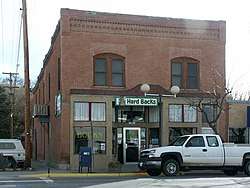 Engleman-Thomas Building |
February 21, 1985 (#85000332) |
200 S. Main 36°49′15″N 108°00′07″W |
Aztec | |
| 20 | Farmington Historic Downtown Commercial District |  Farmington Historic Downtown Commercial District |
December 20, 2002 (#02001551) |
Approximately 8 blocks along Main St. and Broadway, from Auburn Ave. to Miller Ave. 36°43′43″N 108°12′22″W |
Farmington | |
| 21 | Gallegos Wash Archeological District | November 20, 1975 (#75001165) |
Southeast of Farmington[7] |
Farmington | ||
| 22 | Hadlock's Crow Canyon No. 1 (LA 55830) | January 21, 1987 (#86003642) |
On a beach at the confluence of Cuervo Canyon and Canon Largo[8] 36°32′37″N 107°37′55″W |
Farmington | ||
| 23 | Halfway House Archeological Site | October 10, 1980 (#80002565) |
Address Restricted |
Bloomfield | ||
| 24 | Jaquez Site Ruin | December 10, 1984 (#84001281) |
South of the San Juan River[9] 36°45′05″N 108°11′59″W |
Farmington | ||
| 25 | Lower Animas Ditch | March 19, 1987 (#87001116) |
Lower Animas Ditch from Church Ave. to Lovers Lane Historic District 36°50′32″N 107°58′54″W |
Aztec | ||
| 26 | Harvey McCoy House | February 21, 1985 (#85000333) |
725 Pioneer 36°49′45″N 107°59′37″W |
Aztec | ||
| 27 | McCoy-Maddox House | February 21, 1985 (#85000334) |
Northwestern corner of the junction of Maddox and NE. Aztec Boulevard 36°49′45″N 107°59′21″W |
Aztec | ||
| 28 | McGee House | February 21, 1985 (#85000335) |
501 Sabena St. 36°49′52″N 107°59′20″W |
Aztec | ||
| 29 | Morris' No. 41 Archeological District | May 17, 1979 (#79001548) |
Address Restricted |
La Plata | ||
| 30 | Florence and John R. Pond House | September 25, 2013 (#13000773) |
1875 NM 170 36°59′23″N 108°11′13″W |
La Plata | ||
| 31 | Prieta Mesa Site (LA 11251) | January 21, 1987 (#86003647) |
Southeast of Blanco off Road 4450[10] 36°39′39″N 107°37′58″W |
Farmington | ||
| 32 | Salmon Ruin | 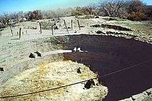 Salmon Ruin |
September 4, 1970 (#70000406) |
Address Restricted |
Farmington | |
| 33 | San Juan River Bridge at Shiprock | July 15, 1997 (#97000740) |
U.S. Route 666 over the San Juan River 36°46′53″N 108°41′31″W |
Shiprock | Six-span Parker through truss bridge. | |
| 34 | Simon Canyon (LA 5047) | 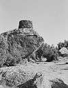 Simon Canyon (LA 5047) |
January 21, 1987 (#86003645) |
North of State Road 511 on the western edge of Navajo Lake State Park[11] 36°49′22″N 107°39′32″W |
Farmington | |
| 35 | Site No. OCA-CGP-54-1 | April 19, 1978 (#78001823) |
Address Restricted |
Fruitland | ||
| 36 | Site OCA-CGP-605 | February 17, 1978 (#78003261) |
Address Restricted |
Fruitland | ||
| 37 | Star Rock Refuge (LA 55838) | January 21, 1987 (#86003643) |
Address Restricted |
Farmington | ||
| 38 | Twin Angels Archeological Site | October 10, 1980 (#80002566) |
On a ridge point overlooking the center fork of Kutz Canyon[12] 36°35′22″N 107°56′33″W |
Bloomfield |
gollark: I believe the implications are obvious.
gollark: Well, you haven't denied being controlled by the cabal of sentient octopi paying Joe Biden.
gollark: Orbital lawsuit lasers *are* charging.
gollark: Who are paid for by entities NOT engaged in the sale or distribution or production of any carbohydrate-based foodstuff.
gollark: I'm blocking you until I can consult with my lawyers.
See also
| Wikimedia Commons has media related to National Register of Historic Places in San Juan County, New Mexico. |
References
- The latitude and longitude information provided in this table was derived originally from the National Register Information System, which has been found to be fairly accurate for about 99% of listings. Some locations in this table may have been corrected to current GPS standards.
- "National Register of Historic Places: Weekly List Actions". National Park Service, United States Department of the Interior. Retrieved on August 14, 2020.
- Numbers represent an ordering by significant words. Various colorings, defined here, differentiate National Historic Landmarks and historic districts from other NRHP buildings, structures, sites or objects.
- "National Register Information System". National Register of Historic Places. National Park Service. July 9, 2010.
- The eight-digit number below each date is the number assigned to each location in the National Register Information System database, which can be viewed by clicking the number.
- Location derived from its GNIS feature record; the NRIS lists it as "Address Restricted"
- Location derived from its GNIS feature record; the NRIS lists it as "Address Restricted"
- Location derived from its GNIS feature record; the NRIS lists it as "Address Restricted"
- Location derived from its GNIS feature record; the GNIS lists it as "Address Restricted"
- Location derived from its GNIS feature record; the GNIS lists it as "Address Restricted"
- Location derived from the canyon's GNIS feature record; the GNIS lists it as "Address Restricted"
- Location derived from the canyon's GNIS feature record; the GNIS lists it as "Address Restricted"
| Topics | |
|---|---|
| Lists by state |
|
| Lists by insular areas | |
| Lists by associated state | |
| Other areas | |
| Related | |
| |
Municipalities and communities of San Juan County, New Mexico, United States | ||
|---|---|---|
| Cities | Map of New Mexico highlighting San Juan County | |
| CDPs |
| |
| Unincorporated communities | ||
| Indian reservations | ||
| Footnotes | ‡This populated place also has portions in an adjacent county or counties | |
This article is issued from Wikipedia. The text is licensed under Creative Commons - Attribution - Sharealike. Additional terms may apply for the media files.