National Register of Historic Places listings in Murray County, Oklahoma
This is a list of the National Register of Historic Places listings in Murray County, Oklahoma.
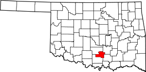
Location of Murray County in Oklahoma
This is intended to be a complete list of the properties and districts on the National Register of Historic Places in Murray County, Oklahoma, United States. The locations of National Register properties and districts for which the latitude and longitude coordinates are included below, may be seen in a map.[1]
There are 8 properties and districts listed on the National Register in the county, including one National Historic Landmark.
- This National Park Service list is complete through NPS recent listings posted August 14, 2020.[2]
Current listings
| [3] | Name on the Register[4] | Image | Date listed[5] | Location | City or town | Description |
|---|---|---|---|---|---|---|
| 1 | Davis Santa Fe Depot | 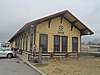 Davis Santa Fe Depot |
December 29, 1994 (#94001507) |
12 Main St. 34°30′12″N 97°07′18″W |
Davis | |
| 2 | Historic Downtown Sulphur Commercial District | Historic Downtown Sulphur Commercial District |
June 14, 2001 (#01000662) |
West Muskogee St. from W. 1st St. to W. 5th St., and W. 5th St. 34°30′27″N 96°58′17″W |
Sulphur | |
| 3 | Initial Point | October 6, 1970 (#70000533) |
About 7.5 miles west of Davis on the Garvin/Murray county line 34°30′24″N 97°14′49″W |
Davis | Extends into Garvin County | |
| 4 | Lowrance Springs Site | March 10, 1975 (#75001567) |
Address Restricted |
Sulphur | ||
| 5 | Murray County Courthouse | Murray County Courthouse |
August 23, 1984 (#84003352) |
Wyandotte Ave. 34°30′17″N 96°58′29″W |
Sulphur | |
| 6 | Platt National Park Historic District | 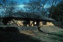 Platt National Park Historic District |
July 7, 2011 (#11000628) |
OK 7 at US 177 34°30′04″N 96°58′28″W |
Sulphur | Historic Park Landscapes in National and State Parks MPS |
| 7 | Sulphur Armory | Sulphur Armory |
May 20, 1994 (#94000487) |
500 W. Wynnewood Ave. 34°30′37″N 96°58′21″W |
Sulphur | |
| 8 | Travertine Nature Center | Travertine Nature Center |
January 25, 2011 (#10001180) |
East of U.S. Route 177 34°30′14″N 96°56′58″W |
Sulphur vicinity |
gollark: ++list_deleted
gollark: You see, I planned for everything except what I didn't plan for.
gollark: What doesn't work? I have no idea what you did.
gollark: Patched what?
gollark: ```May 18 09:08:56 tyr env[1926270]: aiohttp.client_exceptions.ClientConnectorError: Cannot connect to host discordapp.com:443 ssl:default [Connect call failed ('162.159.129.233', 443)]```
See also
| Wikimedia Commons has media related to National Register of Historic Places in Murray County, Oklahoma. |
References
- The latitude and longitude information provided in this table was derived originally from the National Register Information System, which has been found to be fairly accurate for about 99% of listings. Some locations in this table may have been corrected to current GPS standards.
- "National Register of Historic Places: Weekly List Actions". National Park Service, United States Department of the Interior. Retrieved on August 14, 2020.
- Numbers represent an ordering by significant words. Various colorings, defined here, differentiate National Historic Landmarks and historic districts from other NRHP buildings, structures, sites or objects.
- "National Register Information System". National Register of Historic Places. National Park Service. March 13, 2009.
- The eight-digit number below each date is the number assigned to each location in the National Register Information System database, which can be viewed by clicking the number.
| Davis |
| |
|---|---|---|
| Sulphur |
| |
| Topics | |
|---|---|
| Lists by state |
|
| Lists by insular areas | |
| Lists by associated state | |
| Other areas | |
| Related | |
| |
Municipalities and communities of Murray County, Oklahoma, United States | ||
|---|---|---|
| Cities | Murray County map | |
| Towns | ||
| Unincorporated communities | ||
| Indian reservation | ||
| Footnotes | ‡This populated place also has portions in an adjacent county or counties | |
This article is issued from Wikipedia. The text is licensed under Creative Commons - Attribution - Sharealike. Additional terms may apply for the media files.