National Register of Historic Places listings in Craig County, Oklahoma
This is a list of the National Register of Historic Places listings in Craig County, Oklahoma.
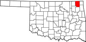
Location of Craig County in Oklahoma
This is intended to be a complete list of the properties on the National Register of Historic Places in Craig County, Oklahoma, United States. The locations of National Register properties for which the latitude and longitude coordinates are included below, may be seen in a map.[1]
There are 10 properties listed on the National Register in the county.
- This National Park Service list is complete through NPS recent listings posted August 14, 2020.[2]
Current listings
| [3] | Name on the Register[4] | Image | Date listed[5] | Location | City or town | Description |
|---|---|---|---|---|---|---|
| 1 | Attucks School | 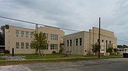 Attucks School |
December 3, 2009 (#09000974) |
346 S. 4th 36°37′55″N 95°09′04″W |
Vinita | |
| 2 | Carselowey House | 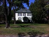 Carselowey House |
December 7, 2011 (#11000894) |
403 N. Gunter St. 36°38′46″N 95°09′29″W |
Vinita | |
| 3 | Craig County Courthouse | 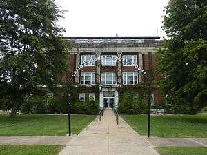 Craig County Courthouse |
August 23, 1984 (#84002994) |
214 W. Canadian Ave. 36°38′14″N 95°09′28″W |
Vinita | |
| 4 | First Methodist-Episcopal Church, South | 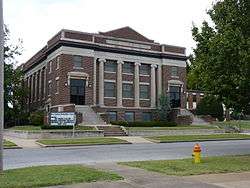 First Methodist-Episcopal Church, South |
June 3, 1999 (#99000673) |
314 W. Canadian Ave. 36°38′17″N 95°09′29″W |
Vinita | |
| 5 | Hotel Vinita | 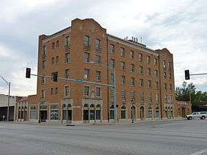 Hotel Vinita |
February 9, 1995 (#94001608) |
Southwestern corner of the junction of Canadian and Wilson Sts. 36°38′12″N 95°09′20″W |
Vinita | |
| 6 | Little Cabin Creek Bridge | 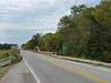 Little Cabin Creek Bridge |
March 4, 2009 (#09000072) |
U.S. Routes 60/69 over Little Cabin Creek, southeast of their junction with Interstate 44 36°37′36″N 95°07′13″W |
Vinita | |
| 7 | McDougal Filling Station | 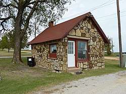 McDougal Filling Station |
May 27, 2004 (#04000521) |
443956 E. Highway 60 36°37′38″N 95°05′22″W |
Vinita | |
| 8 | Randall Tire Company | 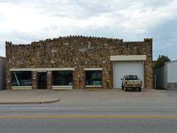 Randall Tire Company |
February 23, 1995 (#95000029) |
237 S. Wilson St. 36°38′30″N 95°09′07″W |
Vinita | |
| 9 | Spraker Service Station | February 23, 1995 (#95000030) |
240 S. Wilson St. 36°38′06″N 95°09′22″W |
Vinita | ||
| 10 | Walker Farmhouse | September 9, 2013 (#13000705) |
Address Restricted |
Welch | Part of the Cherokee Trail of Tears MPS |
gollark: ```RULEFOUR```
gollark: what ifyou utilize the primarily otiose transformative advanced technology or something operation system.
gollark: Yep, I acn seaisejaisjr iti now.
gollark: Very intellect.
gollark: Communism bad.
See also
| Wikimedia Commons has media related to National Register of Historic Places in Craig County, Oklahoma. |
References
- The latitude and longitude information provided in this table was derived originally from the National Register Information System, which has been found to be fairly accurate for about 99% of listings. Some locations in this table may have been corrected to current GPS standards.
- "National Register of Historic Places: Weekly List Actions". National Park Service, United States Department of the Interior. Retrieved on August 14, 2020.
- Numbers represent an ordering by significant words. Various colorings, defined here, differentiate National Historic Landmarks and historic districts from other NRHP buildings, structures, sites or objects.
- "National Register Information System". National Register of Historic Places. National Park Service. March 13, 2009.
- The eight-digit number below each date is the number assigned to each location in the National Register Information System database, which can be viewed by clicking the number.
| Vinita |
| |
|---|---|---|
| Welch |
| |
| Topics | |
|---|---|
| Lists by state |
|
| Lists by insular areas | |
| Lists by associated state | |
| Other areas | |
| Related | |
| |
Municipalities and communities of Craig County, Oklahoma, United States | ||
|---|---|---|
| City | Craig County map | |
| Towns | ||
| CDP | ||
| Unincorporated community | ||
| Indian reservation | ||
| Footnotes | ‡This populated place also has portions in an adjacent county or counties | |
This article is issued from Wikipedia. The text is licensed under Creative Commons - Attribution - Sharealike. Additional terms may apply for the media files.