National Register of Historic Places listings in Cherokee County, Iowa
This is a list of the National Register of Historic Places listings in Cherokee County, Iowa.
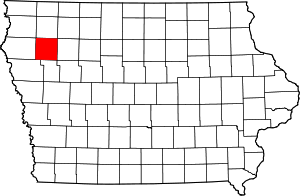
Location of Cherokee County in Iowa
This is intended to be a complete list of the properties on the National Register of Historic Places in Cherokee County, Iowa, United States. Latitude and longitude coordinates are provided for many National Register properties and districts; these locations may be seen together in a map.[1]
There are 12 properties and districts listed on the National Register in the county, including one National Historic Landmark.
- This National Park Service list is complete through NPS recent listings posted August 14, 2020.[2]
Current listings
| [3] | Name on the Register[4] | Image | Date listed[5] | Location | City or town | Description |
|---|---|---|---|---|---|---|
| 1 | Bastian Site | 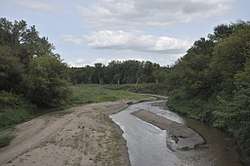 Bastian Site |
July 19, 1976 (#76000742) |
Address Restricted |
Cherokee | |
| 2 | Lemuel C. and Mary (Vaughn) Boughton House | September 27, 2019 (#100004428) |
736 W. Cedar St. 42°45′07″N 95°33′36″W |
Cherokee | ||
| 3 | Brewster Site | March 21, 1979 (#79000887) |
Address Restricted |
Cherokee | ||
| 4 | Cherokee Commercial Historic District |  Cherokee Commercial Historic District |
August 24, 2005 (#05000903) |
Parts of Main, Maple, and Willow between 1st and 6th Sts. 42°45′05″N 95°33′10″W |
Cherokee | |
| 5 | Cherokee Public Library | 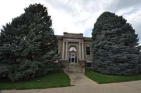 Cherokee Public Library |
April 9, 1985 (#85000773) |
215 S. 2nd St. 42°44′55″N 95°33′04″W |
Cherokee | |
| 6 | Cherokee Sewer Site | December 24, 1974 (#74000777) |
River Rd. south of the Cherokee sewage treatment plant[6] 42°43′22″N 95°34′25″W |
Cherokee | ||
| 7 | Guy M. and Rose (Freeman) Gillette House | September 27, 2019 (#100004427) |
111 N. 11th St. 42°45′02″N 95°33′53″W |
Cherokee | ||
| 8 | Illinois Central Railroad Yard-Cherokee | 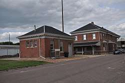 Illinois Central Railroad Yard-Cherokee |
September 6, 1990 (#90001308) |
Roughly bounded by S. 4th, 5th, W. Maple, and W. Beech Sts. 42°44′45″N 95°33′21″W |
Cherokee | |
| 9 | Lewis Hotel |  Lewis Hotel |
September 15, 1997 (#97000963) |
231 W. Main St. 42°44′58″N 95°33′09″W |
Cherokee | |
| 10 | Mill Creek Bridge | 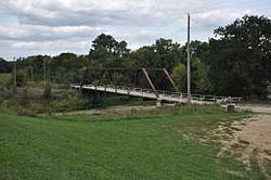 Mill Creek Bridge |
June 25, 1998 (#98000811) |
Old Iowa Highway 21 over Mill Creek 42°46′38″N 95°31′47″W |
Cherokee | |
| 11 | Phipps Site | October 15, 1966 (#66000335) |
Address Restricted |
Cherokee | ||
| 12 | Roy C. and Lena (Johnson) Seaman House | September 27, 2019 (#100004429) |
400 Magnetic Ave. 42°45′12″N 95°32′40″W |
Cherokee |
gollark: It has some very nice things for the cloud-thing/CLI tool/server usecase; the runtime is pretty good and for all garbage collection's flaws manual memory management is annoying, and the standard library is pretty extensive.
gollark: I'm not entirely sure what the aim is - maybe they originally wanted to go for highly concurrent systems or something, but nowadays it seems to mostly be used in trendy cloudy things, servers, command line utilities, that sort of thing.
gollark: I think my use cases are nice usecases, and I think it has flaws even in the domains it seems to be targeted at.
gollark: I think it should at least not, essentially, deliberately cripple itself at some classes of thing.
gollark: I'm not sure exactly what they're targeting - maybe trendy cloud™-type tools, simple webservers, etc - but even *in* that domain it just seems bad to me.
See also
| Wikimedia Commons has media related to National Register of Historic Places in Cherokee County, Iowa. |
References
- The latitude and longitude information provided in this table was derived originally from the National Register Information System, which has been found to be fairly accurate for about 99% of listings. Some locations in this table may have been corrected to current GPS standards.
- "National Register of Historic Places: Weekly List Actions". National Park Service, United States Department of the Interior. Retrieved on August 14, 2020.
- Numbers represent an ordering by significant words. Various colorings, defined here, differentiate National Historic Landmarks and historic districts from other NRHP buildings, structures, sites or objects.
- "National Register Information System". National Register of Historic Places. National Park Service. April 24, 2008.
- The eight-digit number below each date is the number assigned to each location in the National Register Information System database, which can be viewed by clicking the number.
- Anderson, Duane C., and Richard Shutler, Jr. "The Cherokee Sewer Site (13CK405): A Summary and Assessment". Plains Anthropologist 23.82 (1978): 132-139: 134.
| Topics | |
|---|---|
| Lists by state |
|
| Lists by insular areas | |
| Lists by associated state | |
| Other areas | |
| Related | |
| |

Municipalities and communities of Cherokee County, Iowa, United States | ||
|---|---|---|
| Cities | Map of Iowa highlighting Cherokee County | |
| Townships | ||
| Unincorporated communities | ||
This article is issued from Wikipedia. The text is licensed under Creative Commons - Attribution - Sharealike. Additional terms may apply for the media files.