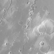
Nanedi Valles
The Nanedi Valles are a set of channels in a large valley in the Lunae Palus quadrangle of Mars, located at 4.9° N and 49.0° W. They are 508 km long and were named for the word for "planet" in Sesotho, the national language of Lesotho, Africa.[1]
 The Nanedi Valles, as seen by THEMIS (click on image to see more detail) | |
| Coordinates | 4.9°N 49.0°W |
|---|---|
The Nanedi Valles are located between Shalbatana Vallis and the upper Maja Valles. They are 4 km wide at their northern end. Their valley's shape is similar to that of Nirgal Vallis, being very sinuous and having only a few short branches.[2]
Unusually for Martian valleys, the individual channel structures within the wider valley floors can occasionally be seen in this system.[3]
Gallery
 Wide view of the Nanedi Valles, as seen by Viking 1 Orbiter
 Close view of the Nanedi Valles, as seen by Mars Global Surveyor (enlargement of the previous image). Arrow points to a small channel that formed after the main valley.
- Close-up of the Nanedi Valles, as seen by THEMIS (click on image to see more detail)
 Section of the Nanedi Valles, as seen by HiRISE under the HiWish program
gollark: ++roll 3d6
gollark: MIPS is obsolete anyway, RISC-V has apinated it.
gollark: Most? Please enumerate at least 23 forms you are not vulnerable to.
gollark: The initial plan was for them to, but due to bureaucratic errors the machines were accidentally inverted and control the weather as well as governmental knowledge of it.
gollark: There's some interesting history there actually.
References
- "Nanedi Valles". Gazetteer of Planetary Nomenclature. USGS Astrogeology Research Program.
- Baker, V. 1982. The Channels of Mars. University of Texas Press. Austin
- Malin, M.C., and Carr, M.H. (1999), Groundwater formation of martian valleys, Nature, 397, 589-592
This article is issued from Wikipedia. The text is licensed under Creative Commons - Attribution - Sharealike. Additional terms may apply for the media files.