N305 highway (Philippines)
The National Route 305 (N305) forms a part of the Philippine highway network. It acts as a four-lane spur road that spans 1.7 kilometers (1.1 mi) and consists two major streets in Olongapo, serving as the main road of Olongapo city proper.
| ||||
|---|---|---|---|---|
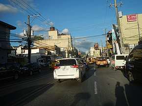 The Rizal Avenue segment of N305 (northbound) in Olongapo. The Ulo ng Apo roundabout intersection can be seen in the background as its northern terminus. | ||||
| Route information | ||||
| Maintained by the Department of Public Works and Highways | ||||
| Length | 1.7 km (1.1 mi) | |||
| Major junctions | ||||
| North end | ||||
| South end | Magsaysay Bridge (pedestrian walkway) | |||
| Location | ||||
| Provinces | Zambales | |||
| Major cities | Olongapo | |||
| Highway system | ||||
| ||||
.svg.png)
Route description
Magsaysay Drive
N305 starts at the Magsaysay Bridge as its southern terminus, a pedestrian walkway where it used to be a roadway for vehicles that provides access to the Subic Bay Freeport Zone until 2011 when SM City Olongapo was built. Magsaysay Drive ends at the Friendship Rotunda, a roundabout intersection that was built in the 1970s.
Rizal Avenue
Going further north, N305 continues the route after the Friendship Rotunda, as Rizal Avenue. the Bajac-Bajac Bridge also crosses the route. N305 terminates at the Ulo ng Apo roundabout as its northern terminus – intersecting with other major roads of Jose Abad Santos Avenue (N3) and Olongapo–Bugallon Road (N306).
Intersections
References
| National primary roads |
| |||||||
|---|---|---|---|---|---|---|---|---|
| National secondary roads |
| |||||||
See also: Philippine expressway network | ||||||||